Forrest Gump may have been filmed over 26 years ago (in and around Beaufort), but the movie has not diminished in popularity. We often get visitors into the welcome center at Frampton Plantation House that are eager to see the local movie locations. The movie was set in Greenbow, Alabama, but was actually filmed, for the most part, in the SC Lowcountry and Savannah. Several locations are not too far from our visitors center at I-95, Exit 33 and Hwy 17. MAP TO LOCATIONS.
During the movie, Forrest is compelled to go to the Four Square Gospel Church to pray for shrimp. These scenes were filmed in the tiny area of McPhersonville, at Stoney Creek Independent Presbyterian Chapel (155 McPhersonville Rd.) This church was built in 1833 and is listed on the National Register of Historic Places.
Comparison image from Houses Then and Now website.Stoney Creek close-up image by Carmen Pinckney.Comparison image from Houses Now and Again website.Image by Carmen Pinckney.
From Frampton Plantation, turn right onto Hwy. 17 and proceed north for 1.4 miles. Turn left onto Hwy 21/ 17-A towards Walterboro. Travel 5 miles, then slow down when you see the Harold’s Country Club sign. Turn left just before this locally famous restaurant onto Pocotaligo Rd. Continue 4.2 miles until you see Sheldon Chapel on the right. (This isn’t the church from the movie, but it is also historically significant.) Turn just before it and proceed slightly farther. The road ends at the church.
Both Varnville comparison images by Houses Then and Now website.
To visit the town where Forrest grew up, head to Varnville, SC. Return to Pocotaligo Rd. and turn left. Travel 11.2 miles miles, then turn right onto Main St. When the road ends, turn right onto Hwy. 278/Gray’s Hwy. Continue for 4.1 miles. The road merges with SC 68. Continue to the left. Once you enter Varnville, turn right onto Main St.
Bluff Plantation comparison images by Houses Now and Then website.
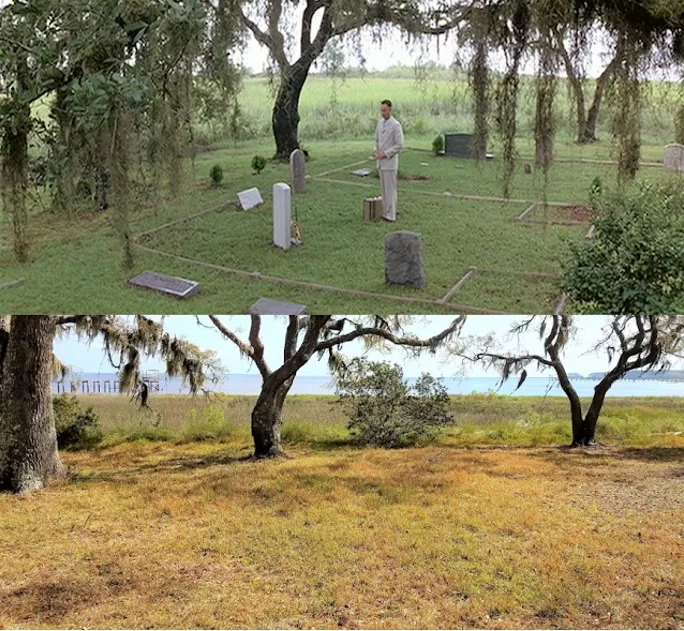
The Gump House is no longer standing. It was built specifically for the movie. Since it was hastily built (not to code) it was dismantled after production. The entrance is still visible. It is on the 8,000-acre Bluff Plantation property. It only took two months to build the house, and only a handful of rooms were finished for filming. Turn left from Main St. and travel down SC Hwy. 68 for 15.1 miles. Take a slight right onto Connely St. in Yemassee for .2 miles. Turn left onto Hwy 17-A and follow it for 3.6 miles. Next turn right onto Combahee Rd. The entrance will be 5.3 miles further at 3547 Combahee Rd. This property is privately owned, so please be respectful. Jenny’s house was also built on this property but was destroyed for the film.
Photograph by Keelie Robinson
The setting for Greenbow’s elementary school is the former Walterboro Academy. It now serves as the Colleton Civic Center. (506 East Washington Street, Walterboro.) This was the setting for the principal’s explanation of Forrest’s intelligence testing scores. From Bluff Plantation, return 5.3 miles to Hwy 17-A and turn right. Travel toward Walterboro for 11.5 miles. Take a slight right onto S. Jeffries Blvd. In 1.8 miles turn right onto Hampton St. The destination will be .4 miles away on the right.
Image from Houses Then and Now website.Image by Glenn Hanna.
After you leave this scene, head to Beaufort via Hwy 21/Carteret St. The Woods Memorial Bridge connects Beaufort to Lady’s Island. This is the scene for the running bridge interview. This is not the mighty Mississippi, but the Beaufort River. This historic swing bridge connects Beaufort to the sea islands. It is one of a handful of swing bridges that still exist in the state. It’s also the home of the annual “Run, Forrest Run 5K”.
Image by Houses Then and Now.Image by Corey Gibson.
The house where Bubba lived is next on the tour. Continue across the bridge and just over a mile. Turn left at the light onto Sam’s Point Rd. Keep going through the traffic circle (take the second exit). Stay on Sam’s Point Rd. for six miles. Turn left onto Alston Rd. 145 Alston Rd. will be on the right. This 1,240 square foot house was built in 1940. Bubba’s grave site was constructed in the back yard. This is a private residence. Please be respectful. The water adjacent to the house is the Lucy Point Creek. That’s where the majority of the shrimp boat scenes.
Comparison image by Now and Again website.Comparison image by Now and Again website.
Bubba’s momma was played by Dr. Marlena Smalls. This classically trained soprano founded Beaufort’s Gullah Festival and the Hallelujah Singers. Her singers were also featured in the movie. She is well-known for using music and stories to educate others about Lowcountry Gullah customs and beliefs.
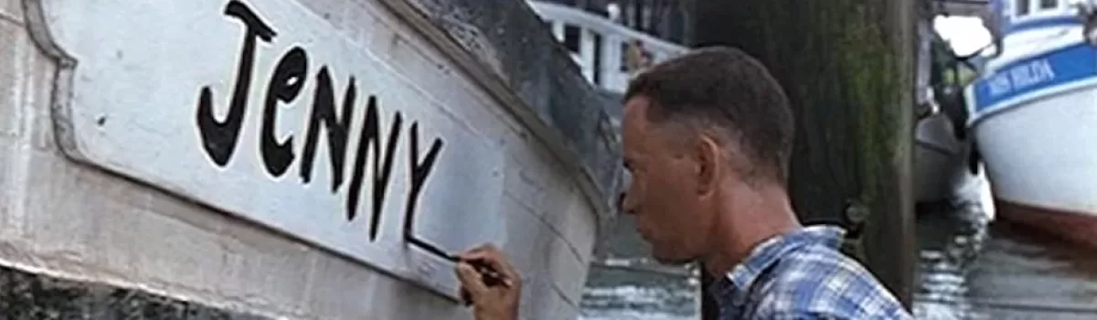
To visit the Vietnam war scenes, return down Sam’s Point Rd. and back to Hwy 21. Turn left onto Hwy 21/Sea Island Pkwy. As you drive toward Hunting and Fripp Islands, notice the march and waterways. They should look familiar. You will also pass Gay Fish Company on the right. They supplied all the shrimp for the movie.
Image courtesy of SC Lowcountry Tourism Commission.
Their dock is also where Forrest paints ”Jenny” on his boat. The Gay Seafood boat “Miss Hilda” can be seen in the background of that scene. Docked shrimp boats paint a beautiful scene. Travel for 16.8 miles. You will drive past the entrance to Hunting Island State Park.
The boardwalk will be on the right. Park and walk along the boardwalk while you’re here. The war rescue scene that earns Forrest a medal happened inside the park at the lagoon.
The Ocean Creek Golf Course at Fripp Island was also the location for war scenes. The mountains and larger palm trees were added by special effects.
American Bald Eagle hunts over the waterways of Bear Island WMA. Photo by Jim Killian.
If birding is your passion, Bear Island Wildlife Management Area is the place for you! This Lowcountry barrier island is managed to provide quality habitat for wintering waterfowl and other wetland wildlife including threatened and endangered species such as wood storks and bald eagles. Here you’ll find a vast array of waterfowl, wading birds, shorebirds and songbirds. There are two observation platforms and miles of dikes that provide numerous wildlife viewing opportunities.
Roseate Spoonbills are a favorite at Bear Island. Image by Kristin Baggett.
Bear Island is managed to provide quality waterfowl habitat and to protect local endangered and migratory non-game species. Public recreational opportunities are provided for hunting, nature observation and fishing. Explore thousands of acres containing managed impoundments at 27 different sites.
An Osprey searches for her next meal. Photo by Jim Killian.
Bear Island is a major wintering area for waterfowl as well as an important shorebird area during migration. It is also an important nesting area for Bald Eagles and a foraging area for wading birds including Wood Stork, Little Blue Heron, Snowy Egret, Great Egret, Tri-colored Heron, White Ibis and Glossy Ibis. Concentrations of migratory shorebirds include Greater and Lesser Yellowlegs, Dowitcher and Common Snipe. Shorebird concentrations are noted during times of pond drawdown associated with the waterfowl management program.
Canadian Geese and Tundra Swans have been spotted at Bear Island. Photo by Jim Killian.
Bear Island is part of the ACE Basinestuarine reserve area and is managed by the South Carolina Department of Natural Resources. The area is open to the public from early February to late October and is a popular spot for hiking, biking, birding, and fishing. A wide variety of waterfowl species inhabit the area. The area shuts down periodically for special hunts.
A Belted King Fisher waits patiently on its perch. Photo by Jim Killian.
Bear Island is one of the best birding areas in the state. Be on the look-out for Canada Goose, Tundra Swan, Great Blue Heron, Great Egret, Snowy Egret, Little Blue Heron, Tricolored Heron, Green Heron, Black-crowned Night-Heron, White Ibis, Glossy Ibis, Wood Stork, Osprey, Bald Eagle, and Roseate Spoonbill. In addition to common birds of the Coastal Plain and the specialties listed above there is a long list of rarities that have been spotted here, including—among others—Black-bellied Whistling-Duck, Eurasian Wigeon, Cinnamon Teal, Common Goldeneye, Eared Grebe, Roseate Spoonbill, Black Rail, American Avocet, Hudsonian Godwit, White-winged Dove, Barn Owl, Short-eared Owl, Western Tanager, and LeConte’s Sparrow.
Herons are a common sight at Bear Island. Photo by Jim Killian.
The main part of Bear Island is open to birders Monday through Saturday, from 1 February through 14 October. At other times birders are restricted to areas right along Bennett’s Point Road, including Mary’s House Pond, which is just south of the residences by the main entrance. Do not go in to closed areas, even if the gate is not locked, or you risk getting a ticket.
This egret makes a successful catch. Photo by Jim Killian.
The best birding is usually along the main unpaved road east from Bennett’s Point Road, called Titi Road. A good strategy is to park along Titi Rd and walk in along any of the many side roads. If you have time you might also want to check one or more of the roads that lead west from Bennett’s Point Road. It takes at least a day to enjoy the entire area.
Bear Island is located off Highway 17, between Edisto Island and Beaufort in Green Pond. From Hwy 17, turn onto Bennett’s Point Rd and travel 13 miles. The entrance is on the left, approximately 1 mile after crossing the Asheepoo River.
Wading birds of all sizes hunt and nest on Bear Island. Photo by Jim Killian.
Just south of Charleston and north of Savannah, a natural paradise awaits your visit! The historic Kings Highway 17 travels through the beautiful SC Lowcountry and these protected treasures.
Wood stork image captured by Ira Runyan at Donnelley Wildlife Management Area.
The area that lies between Charleston and Savannah is a nature lover’s paradise. Here you will find wildlife management areas, nature trails, church ruins and a welcome center located in a historic house.
1. Ernest F. Hollings ACE Basin National Wildlife Refuge
ACE Basin Oak Grove Plantation House photo by Carmen Pinckney.
The Ernest F. Hollings ACE Basin National Wildlife Refuge is located off Hwy 17, on Hwy 174 towards Edisto Island. The refuge is home to a vast array of waterfowl, and the Antebellum Oak Grove Plantation House.
Stretch your legs and visit the trails of the ACE Basin National Wildlife Refuge. Photo by Carmen Pinckney.
A walk behind the house leads visitors to the former rice fields. Rows, dikes, trunks, and gates are still visible today. The paths are marked and meander around the rice fields and wooded areas. Make sure to bring your camera and be on the lookout for wildlife. For more information visit https://southcarolinalowcountry.com/ernest-f-hollings-ace-basin-national-wildlife-refuge/.
2. Botany Bay Wildlife Management Area
Drive through the Lowcountry’s most photographed live oak canopy at Botany Bay. Photo by Carmen Pinckney.
A venture further down Hwy 174 onto Edisto Island will bring you to the wildlife management area of Botany Bay Plantation. This is one of the most unique destinations on Edisto Island. The 4.000+ acre property boasts historical buildings, maritime forest, a boneyard beach and freshwater ponds. The property is covered in pine, palm and live oak trees, dripping with Spanish moss. Don’t be surprised to see deer, alligators, shore birds, crabs, raccoons and many other maritime forest creatures.
Botany Bay’s boneyard beach is covered in shells. Photo by Carmen Pinckney.
There are two sites listed on the register of historic places at Botany Bay. A set of three surviving 1840s outbuildings and the prehistoric Fig Island Shell Ring can be seen on the property. Explore the plantation house ruins, walk the forest trails, or stroll the beach on this South Carolina controlled wildlife management area. Botany Bay Wildlife Management Area is a great place to spend a day. Bring a picnic, beach chairs and kayaks. Explore the wonders of the South Carolina Lowcountry! For more information visit https://southcarolinalowcountry.com/edisto-islands-botany-bay/.
3. Edisto Nature Trail
Edisto Nature Trail photo by David Lucas.
Jacksonboro is the perfect spot to get out and stretch your legs on the Edisto Nature Trail. The trail is located on Highway 17, adjacent to the Edisto River. Jacksonboro is in the area known as the ACE Basin. This low-lying part of the state is full of former rice plantations with beautiful marsh and river views, and teaming with wildlife.
Edisto Nature Trail photo by David Lucas.
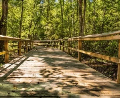
The boardwalk trail meanders through the woods that change from pineland and maritime forests to cypress and tupelo swamp. Before and after the Revolutionary War, this area was rich in rice production. A 15-minute walk along the boardwalk will take you to a dock overlooking the Edisto River. You can also press on and take the 1.5-mile loop trail that can be completed in about an hour. It will transport you from the wetlands to higher upland forest area. Make sure to wear appropriate shoes. Be sure to bring bug spray if you come in the spring or summer. For more information visit https://southcarolinalowcountry.com/hiking-the-edisto-nature-trail/.
4. Bear Island Wildlife Management Area
Bear Island image by Pluff Mudd Perspectives.
Bear Island Wildlife Management Area is located off Hwy 17 in the Green Pond area. This wildlife management area is managed to provide quality habitat for wintering waterfowl. It’s a great spot to view bald eagles, wood storks and roseate spoonbills.
Bear Island is a great place to photograph birds. Photo by Jim Killian.
Drive through this area for many opportunities to spot wildlife. The forest, marsh and river views are beautiful. Bear Island is located between the Asheepoo and South Edisto Rivers. From Hwy 17, turn onto Bennett’s Point Road and follow for 13 miles. The entrance is on TiTi Road. (843)844-8957. For more information visit https://southcarolinalowcountry.com/explore-sc-lowcouontry-wildlife-preserves-and-nature-trails/.
5. Donnelley Wildlife Management Area
Donnelley Wildlife Management Area drive image by Carmen Pinckney.
Donnelley Wildlife Management Area is a favorite spot for tourists and locals alike. It is located on Hwy 17 in Green Pond (between Yemassee and Jacksonboro) in the heart of the ACE Basin. This is a great place to glimpse Lowcountry nature at its finest. The property features a historic rice field system, which is now managed to attract waterfowl and migratory birds. The drive is pleasantly lined with beautiful old live oaks.
Roseatte Spoonbills can be found at Donnelley, along with many other species of birds.
The driving tour covers about 11 miles and should take from an hour to half a day, depending on how many stops you make. The marked stops on the map serve simply as suggestions; feel free to stop anywhere along the way (although please park on the shoulder) and walk off the road at any point to get a closer look at wildlife or native plants. Take extra precautions when viewing alligators, especially during the spring mating season. For more information visit https://southcarolinalowcountry.com/colleton-countys-donnelley-wildlife-management-area/.
6. Old Sheldon Church Ruins
Old Sheldon Church Ruins image by Carmen Pinckney.
A simple turn off Hwy 17 onto Old Sheldon Church Road is like stepping back in time. Travel up the road for about two miles and see the church ruins on the right. Parking is located across the street. This church was burned during the Revolutionary War, rebuilt, and then destroyed again during the Civil War.
Old Sheldon Church Ruins includes a historic graveyard. Photo by Carmen Pinckney.
Located just past the turn to Beaufort off Hwy 17, Sheldon Church has laid in ruin for more than 140 years. Its gable roof, pediment, windows & interior have disappeared, but the classic simplicity of its design still remains. Burned by British troops in 1779 and destroyed again during the Civil War it still serves as a religious center for special observances. For more information visit https://southcarolinalowcountry.com/experience-a-driving-detour-through-yemassee/.
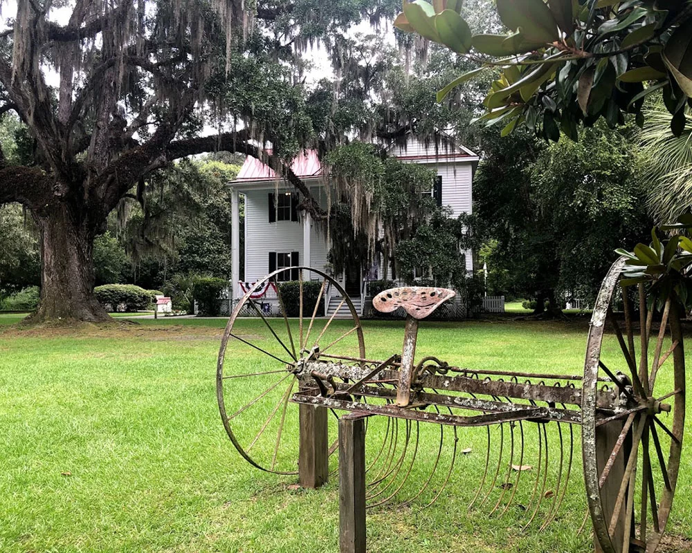
7. Frampton Plantation House & Visitors Center
Frampton House sits conveniently at the intersection of I-95 and Highway 17. Photo by Carmen Pinckney.
Historically speaking, the Frampton House property was part of an original King’s Grant to the Frampton family in the 1700s. The family oversaw the production of 4,000 acres of cotton, rice, and other crops. During the 1865 Campaign of the Carolinas, General Sherman’s troops burned the plantation house and all the farm buildings that stood on this site.
Go back in time at Frampton House. Photo by Carmen Pinckney.
The house was rebuilt in 1868 and the property was probably used for share cropping and tenant farming. Once slated for demolition, the house has been restored and the ground floor is open to the public. The second story holds the offices of the Lowcountry Tourism Commission. Frampton House is open to the public seven days a week, from 8:30 a.m. – 5:00 p.m. Come see us for all your SC Lowcountry travel questions and insider secrets. For more information visit https://southcarolinalowcountry.com/history-is-preserved-at-frampton-plantation-house/.
8. Blue Heron Nature Trail
Blue Heron Nature Trail travels along a pond and Lowcountry wetland. Photo by Lynn Boyles.
Blue Heron Nature Center & Trail offers relief for the road-weary, and it’s as easy to get to as any rest area.
This 10-acre green space meanders around a three-acre pond and through forested wetlands. The property also includes a butterfly garden, picnic area, outdoor classroom, observation decks, and a 4,200-square-foot Learning Center. Permanent trail side displays help visitors learn more about the native flora and fauna of Jasper County and the Lowcountry.
Look for turtles and fish from the docks at Blue Heron Nature Trail. Photo by Lynn Boyles.
The nature trail leads you around the pond with several scenic overlooks along the way. Along the trail you will find benches, swings, and an attractive butterfly garden. In addition to the herons, you may see ducks, turtles, fish, alligators, and other wildlife. Also, several boardwalks take you through the surrounding forested wetlands. Get out of the traffic and spend some time relaxing while you wander around this natural gem. For more information visit https://southcarolinalowcountry.com/lowcountry-activities-ridgeland-i-95-exit-21/.
9. Sgt. Jasper Park
The boardwalks at Sgt. Jasper Park are wheelchair friendly. Photo by Carmen Pinckney.
Hardeeville’s Sgt. Jasper Park is conveniently located off I-95, at Exit 8. After exiting the interstate, point toward Hilton Head and turn left at the first traffic light. Follow the road around until you bump into the park entrance. Trails are located on both sides of the road. Some trails are wheelchair accessible. This is a great place to get off the interstate and stretch your legs. Dogs are welcome here, on a leash. A trail map is available in the park office.
Lowcountry nature trails are great places to walk the family dog while travelling. This trail is at Sgt. Jasper Park. Photo by Carmen Pinckney.
The trails alternate between gravel, boardwalk and natural footing. The views around the lake are pretty, and the trails are relaxing. There are other opportunities at the part as well. There are canoes, kayaks, and a disk golf course. Information can be found in the park office. There’s a playground for the kids and plenty of picnic spots. There is also a covered picnic shelter. Grills can be found at the park as well. The disk golf course is located on the left side of the road. The park also has fishing opportunities. For more information visit https://southcarolinalowcountry.com/spending-time-at-sgt-jasper-park/.
10. Savannah National Wildlife Refuge
The Savannah National Wildlife Refuge still operates a historic trunk system that controls water flow into the former rice fields. Photo by Allyson Jones.
The Savannah National Wildlife Refuge offers a variety of opportunities to explore and enjoy the great outdoors from sunrise to sunset every day. You can observe and photograph wildlife. Make the Savannah National Wildlife Refuge Visitor Center your first stop when visiting the refuge. The refuge is located on Hwy 17 between Hardeeville and Savannah.
Drive through or hike the trails of the Savannah National Wildlife Refuge. Photo by Allyson Jones.
The Savannah National Wildlife Refuge protects old rice fields & numerous species of wildlife including ducks, birds, deer, & alligators. The 4-mile driving tour is free and open sunrise to sunset. Wildlife viewing is excellent for photography, especially during fall, winter, and spring, along the 4-mile Laurel Hill Wildlife Drive and adjacent hiking/bicycling trails. Many species of wading and marsh birds can also be spotted here throughout the year.
The unspoiled natural habitat of the SC Lowcountry is pristine breeding grounds for many birds. This bald eagle was spotted at Bear Island by Rhonda Epper.
Visitors could easily spend several days in the area exploring all the natural wonders located between Charleston and Savannah on Highway 17. Pick a few favorites or see them all. The choice is yours. Bring along the camera, a picnic and don’t forget the bug spray!
Pack a picnic and stop for lunch at Frampton House. Enjoy free wifi, picnic tables, clean restrooms and a friendly staff ready to help you on your journeys.
Visitors could easily spend several days in the area exploring all the natural wonders located between Charleston and Savannah on Highway 17. Pick a few favorites or see them all. The choice is yours. Bring along the camera, a picnic and don’t forget the bug spray!
If you’re looking for a more civilized picnic spot under the oaks, plan to have lunch at Frampton Plantation House. Our ground floor contains a visitors center, complete with restrooms, museum displays and a gift shop. The backyard has picnic tables and plenty of room to stretch your legs. As always, pets are welcome both inside and out! Our friendly staff can answer any questions or give suggestions for their favorite attractions in the area. For more information visit https://southcarolinalowcountry.com/ or call 843-717-3090.
To download a PDF version of the map, complete with addresses and phone numbers click HERE.
With summer quickly approaching, SC Lowcountry Farmers Markets are in full swing! Enjoy some fresh air, browse, and take home local produce.
While social distancing and wearing masks are still important habits to keep, the markets are open and have plenty to sell! Each market takes place out of doors in the fresh air. Check your calendar, find your market basket and head to SC Lowcountry farmers market that’s closest to you!
The Port Royal Farmers Market is open from 9 a.m. – noon each Saturday. The market officials ask that all visitors wear a mask and observe social distancing rules. Vendors will also accept preorders. Some of the items available include red potatoes, white potatoes, yellow squash, cucumbers, fresh bread, meats from Calibogue Catering, bakery goodies, shrimp, breakfast sandwiches, poultry products, flowers, and fresh pasta.
For more information or to sign up for weekly information visit https://portroyalfarmersmarket.com/. You can also sign up for their weekly newsletter alerting you to what’s going to be at the market for the week.
The Farmers Market of Bluffton is another Lowcountry favorite. Every Thursday, from 12-3 p.m. Calhoun Street is closed to traffic and transformed into a street market. Shop for fresh pasta, in season fruits and veggies, homemade bread and bakery items, fresh meats, jams and jellies, and prepared goodies. Don’t miss Hank’s Lowcountry she crab soup and the Cottage Bakery. If it’s a scorcher, treat yourself to a Palmetto Ice Pop!
The Bluffton Farmers Market information can be found on https://www.farmersmarketbluffton.org/. You can also sign up for their weekly newsletter to find out about what’s in season and for sale on Calhoun Street.
The Hilton Head Farmers Market happens every Tuesday, from 9 a.m. – 1 p.m. on the grounds of historic Honey Horn Plantation. Take home fresh local produce, pasture raised chicken, free range rabbit, pork, seafood, salsa, fresh sausage, cookies, breads, she crab soup, and more. Free parking in the Coastal Discovery Museum parking lot, 70 Honey Horn Drive.
Local farmers, producers, vendors, and food trucks will be at the market to share the bounty of their crops. Three Sisters Organic Farm will be there to sell fresh zucchini, cucumbers, and tomatoes. The Grind Roasters will be there as well, to grind your favorite flavors of coffee. For more information visit https://www.coastaldiscovery.org/.
Ridgeland’s Jasper County Farmers Market kicks off the weekend every Friday from 1 – 6 p.m. The Market will host a variety of vendors including produce, baked goods, prepared meals, arts, crafts and estate sales.
You can find the Jasper County Farmers Market on Main Street, across from Fiddler’s Seafood Restaurant. For more information visit http://jaspersc.org/farmers-market/.
If you’re in Walterboro, the Colleton Museum and Farmers Market offers fresh vegetables and fruits, local honey, local crafts, plants, baked goods, prepared food, music, and much more. The market is open on Saturdays from 9 a.m. until 1 p.m.
The mission of the market is to “encourage, support, and promote the entrepreneurial efforts of local, independent, small-scale farmers, food artisans and crafters seeking to sell products directly to the consumer while operating independently from large corporate or factory farms and businesses.” You can find the market at 506 East Washington St., in historic downtown Walterboro. For more information visit http://www.colletonmuseum.org/farmers-market.
Downtown Beaufort’s Henry C. Chambers Waterfront Park looks onto the Beaufort River. Photo by Peach Morrison.
Thinking about planning a trip to the South Carolina Lowcountry? Why not plan a relaxing vacation in an area that is known for its scenic beauty and historic architecture. The SC Lowcountry is the perfect spot to enjoy a vacation that includes quaint southern towns, beautiful beaches and wide open spaces.
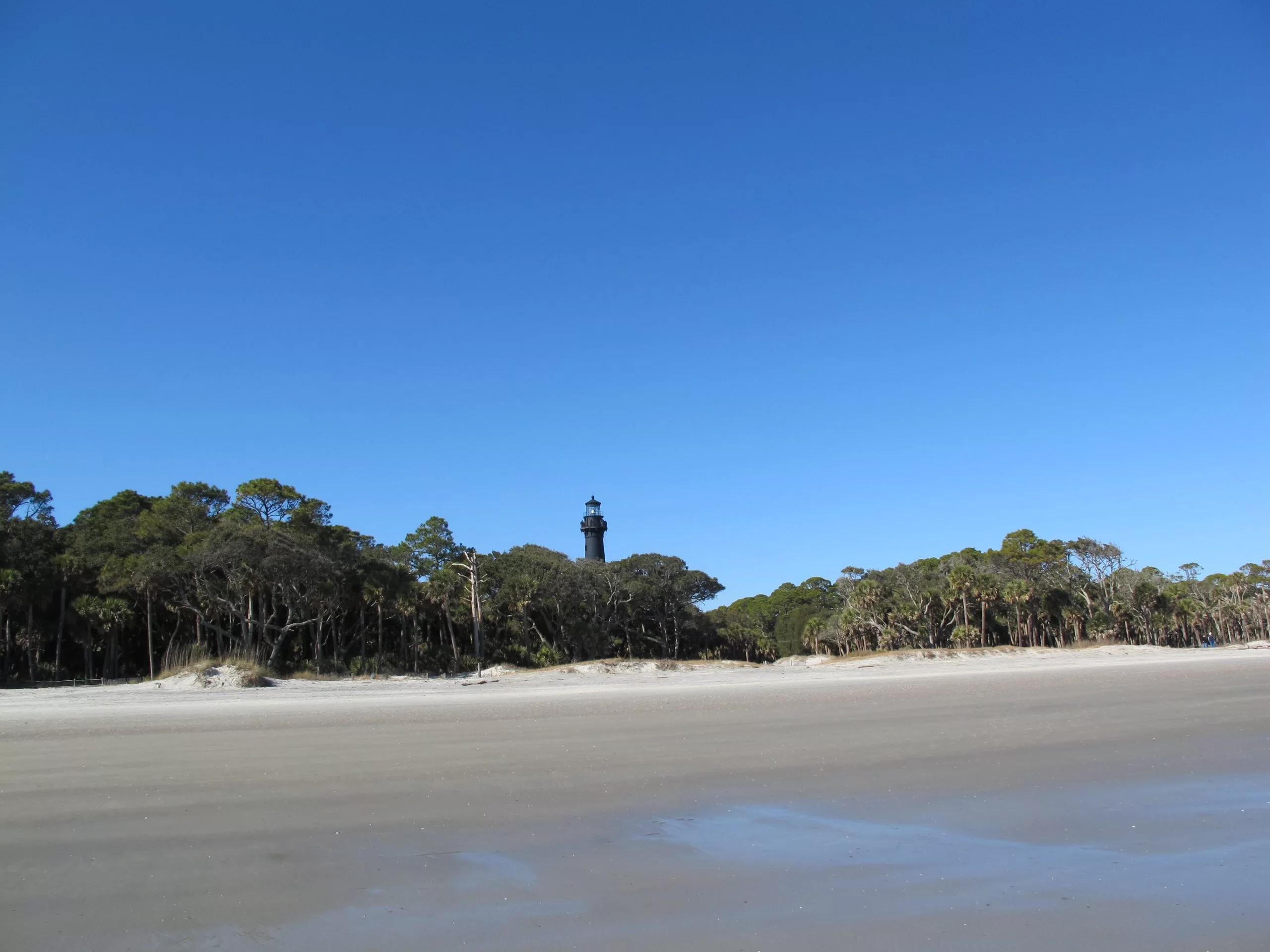
Hunting Island image by Allyson Jones.
Hunting Island State Park is located 17 miles from downtown Beaufort. The park has 5,000 acres of beaches, hiking trails and plenty of fishing opportunities. Kayak, paddle board or hunt for crabs at the lagoon. Fish from the pier. Camp on the beachfront! Walk the many miles of the semi-tropical maritime forest that was used in the movies Forrest Gump and Jungle Book. Call 843-838-2011 for more information.
Spend the weekend at the historic Beaufort waterfront. Head downtown Beaufort and enjoy lunch at one of the many waterfront restaurants. Relax, soak up sunrays from the swings and watch the river roll gently by. When the sun goes down, head out to the Hwy 21 Drive-in to catch a double feature.
Downtown Beaufort photo by BeaufortPics.com.
Beaufort has many outdoor dining options in the waterfront area. These restaurants are a great destination for your family. Sit on the deck, watch the clouds roll by overhead and enjoy some amazing food.
Beaufort fell very early during the Civil War. Homeowners abandoned the city and Union troops used it as army headquarters. Homes and churches became hospitals, offices, and officer’s quarters. Because of this, the city and its beautiful homes were spared from fire and destruction.
Views from the Spanish Moss Trail are beautiful.
Bring your bike and ride the Spanish Moss Trail. This green space was made where the railroad once brought recruits from Yemassee to Parris Island. The trains also carried lumber, meat and produce from Beaufort farms. The trail stretches from Port Royal to rural Beaufort County toward Yemassee.
Savannah National wildlife Refuge image by Daniel Pillatzki.
The Savannah National Wildlife Refuge is another great space to get back to nature. The refuge can be found on the Savannah River, between Hardeeville and Savannah. You will find a variety of opportunities to explore and enjoy the great outdoors from sunrise to sunset every day. You can observe and photograph wildlife, fish and hike the many trails.
Photo by Charlotte Pinckney.
Fish the Savannah River from Millstone Boat Ramp in Hardeeville or B & C Boat Landing at the Tillman Sandridge Wildlife Management Area. Common species found in the impoundments and canals are bluegill, crappie, large-mouth bass, channel and blue catfish, bowfin, and mullet, plus striped bass, red fish, and flounder.
Visit Frampton Plantation. Conveniently located on I-95, Exit 33, The Frampton Plantation House serves as the home of the Lowcountry Tourism Commission. The downstairs is open to the public. It is used as a visitor center with museum displays, tourist information and gift shop. The backyard has a lovely picnic spot under the Spanish moss draped live oaks. There’s also plenty of room to run around with the dogs.
Walterboro’s Great Swamp Sanctuaryis a beautiful place to spend some quality time. The sanctuary contains a network of boardwalks, hiking, biking, and canoe trails that are perfect for viewing a diversity of a black water bottomland habitat. Wild turkey, deer, raccoons, beaver, otter, mink, opossum, squirrels, fox, alligators, and wildcats have been spotted here. Bikes and dogs on leashes are welcome on the pathways of the sanctuary, so load up the family and make your way to this nature-based tourism gem
Downtown Walterboro is another great destination. The city is a popular spot for antiquing. Washington Street has a vast assortment of antiques stores loaded with interesting finds. The Colleton Museum and Farmers Market is located at the end of Washington Street. Visit their Marketplace Café for fresh bakes goods. Beautiful homes can be found everywhere in downtown Walterboro. A walk is the best way to appreciate the lovely structures that were used as summer homes for nearby plantations. Take a nice, leisure stroll to photograph these beauties. Hampton Street is a favorite walking destination. Start here and let your feet guide you through the neighborhood.
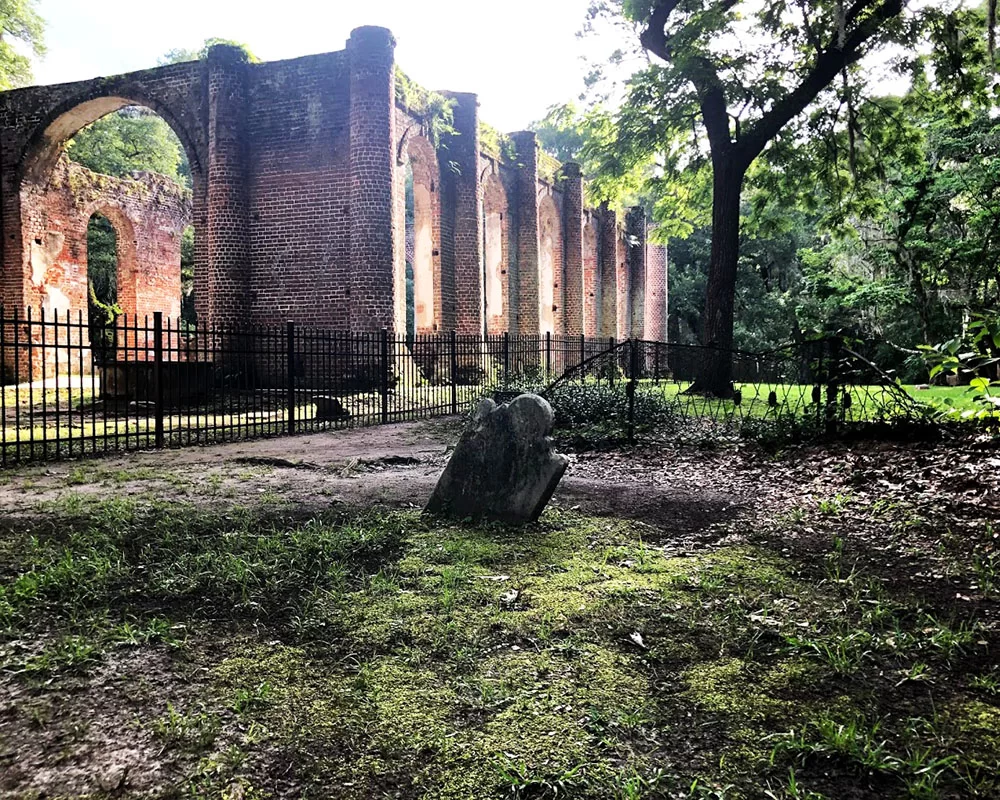
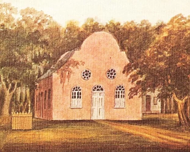
Standing sentinel in the isolated woods of Colleton County, Pon Pon Chapel of Ease was once the center of a bustling thoroughfare. Located on what was once a busy stagecoach road, the ruins of this beautiful chapel are all that remains in the area. During the early days of American history, Parker’s Ferry Road connected Charleston and Savannah. President George Washington used this road during his 1791 Spring Tour. Rumor has it he even stopped to worship at the chapel.
Cemetery and back view image by Sara Dean.
Pon Pon Chapel was established during the Colonial Period in 1725 as the first Anglican church in the state. A brick chapel was built in 1754, to replace an earlier wooden structure. This chapel burned in 1801 and became known as Burnt Church. The structure was rebuilt in the early 1820s. The chapel was used lovingly until 1832 when, according to the National Register of Historic Places application, it was either burned or fell into disrepair. Nearby Jacksonboro was replaced by Walterboro as the county seat. As parishioners migrated to Walterboro, there was no need to rebuild. Hurricane Gracie came through the area in 1959 causing further destruction to the structure.
The front of Pon Pon Chapel was repaired in 1975. Image found on the National Register of Historic Places website.
The founder of the Methodist Church, John Wesley preached two sermons from the pulpit of Pon Pon Chapel in 1737. Locals continued to use the churchyard for burials. Two congressmen and several other local leaders are buried here. The Colleton County Historical and Preservation Society acquired the ruins and four acres in 1970. The front facade of the chapel was repaired and stabilized in 1971, then admitted to the National Register of Historic Places in 1972. A grant was awarded to repair the front facade of the chapel in 1975. These ruins stand as a reminder of the early establishment of the Anglican Church in the area.
Pon Pon watercolor image shared by Charles Fraser.
Pon Pon’s façade has a central, arched entrance and matching windows on either side. Upper level round windows also grace the front. Large rods stabilize the façade from behind. If you look carefully, you will notice the Flemish Bond brickwork, characteristically constructed with alternating rows of headers and stretchers.
Pon Pon Chapel Ruins can be found off Hwy 64, between Walterboro and Jacksonboro.
Pon Pon Chapel ruins can be found of Hwy 64 (Jacksonboro Road), just outside Jacksonboro at Burnt Church Crossroads. Look for the sign between Jacksonboro and Walterboro. Turn down the dirt road and proceed until you see power lines. The ruins are located just before the power line easement on the right. For more information on Walterboro and Colleton County sights to see, visit https://southcarolinalowcountry.com/walterboro-colleton-county/.
Wildlife biologist Charles Pinckney enjoys birding in the SC Lowcountry. Photo by Carmen Pinckney.
Exploring SC Lowcountry Parks is a great way to get outdoors! During these stressful times, it is important for us to maintain our connection with nature. While we’re all social distancing and staying home, it’s a good idea to get outdoors and soak up sunshine and fresh air. If we take precautions and listen to the guidelines put in place by our leaders, exploring a park is just what the doctor ordered! Colleton, Beaufort, Hampton and Jasper Counties have a multitude of outdoor possibilities to connect with nature. For additional information and maps of these properties visit https://southcarolinalowcountry.com/wildlife-preserves-and-nature-trails/.
Colleton County and Walterboro have some wonderful parks and wildlife management areas. Whether you want to stretch your legs or take a scenic car ride, these natural wonders have something for everyone.
ACE Trail image found on Friends of the Ace Trail website.
The ACE Trail is located two miles north of the intersection of Hwy 17 and SC HWY 303 in Green Pond. This trail runs along the abandoned Atlantic Coast Railroad Line that parallels SC Hwy 303. This trail is currently 2.8 miles, but another extension is planned soon. The trail is ideal for walking, biking and bird watching. The trail head has picnic tables and plenty of space for parking.
Colleton State Park borders the Edisto River. Image found on southcarolinastateparks.com.
Colleton State Park borders the Edisto River. Here, you’ll find a short, easy walking loop trail that travels along the river. Signs are placed along the trail to help you identify a variety of trees and plants, including Cypress trees. While here, look for birds, deer, turtles and other wildlife. The park can be found at 147 Wayside Lane, Walterboro – just a few miles off I-95.(843)538-8206
The ACE Basin National Wildlife Refuge is home to a large variety of wildlife. Image by Hometown Hiker.
Ernest F. Hollings ACE Basin National Wildlife Refuge has trails that weave through the forest and across dikes of a historic rice plantation. The refuge also has one of the few remaining antebellum houses in the area. This refuge protects the largest undeveloped estuary along the Atlantic Coast. The area is home to a wide variety of wildlife. The refuge is located at 8675 Willtown Road, Hollywood, SC, on the way to Edisto Beach. (843)889-3084
Bear Island Wildlife Management Area is a great place to look for bald eagles. Photo by Rhonda McFadden Epper.
Bear Island Wildlife Management Area is located off Hwy 17 in the Green Pond area. This wma is managed to provide quality habitat for wintering waterfowl. It’s a great spot to view bald eagles, wood storks and roseate spoonbills. Drive through this area for many opportunities to spot wildlife. The forest, marsh and river views are beautiful. Bear Island is located between the Asheepoo and S Edisto Rivers. From Hwy 17, turn onto Bennett’s Point Road and follow for 13 miles. The entrance is on TiTi Road. (843)844-8957
Former rice fields at Donnelley Wildlife Management Area are breeding grounds for American alligators. Photo by William Purcell.
Donnelley Wildlife Management Area has more than 8,000 acres of diverse wildlife habitats. This property features a historic rice field system that is now managed to attract waterfowl and migratory birds. The former rice plantation is nestled between the Combahee and Asheepoo Rivers. All types of wildlife can be found here. There are 11 miles of roads that can be driven through the property. There are also walking trails that lead to dikes that cross old rice fields. Herons, egrets, ibises and many more varieties of birds can be found on this freshwater wetland. Located at 585 Donnelley Drive in Green Pond. The entrance is at the intersection of US Hwy 17 and SC Hwy 303. (843)844-8957
The Walterboro Wildlife Sanctuary is in the heart of historic Walterboro. Photo by walterborosc.org.
Just three minutes of I-95, the Walterboro Wildlife Sanctuary is a great place to get back to nature. There are trails for hiking, biking and even canoeing. This wildlife sanctuary is in the heart of downtown Walterboro. Parking can be accessed on DeTreville Street. Boardwalks lead through a braided creek with a diversity of wildlife that inhabit the black water bottomland. (843)538-4353
The drive into Botany Bay is one of the most photographed live oak avenues in the Lowcountry. Photo by Carmen Pinckney.
Botany Bay Plantation Wildlife Management Area can be found on the way to Edisto Beach. This wildlife management area borders the Atlantic Ocean and the North Edisto River. Beach access is closed until further notice, but the remainder of the property is open. Drive through this undeveloped wetland ecosystem, then park to walk trails located throughout the property. The remains of two plantations can be explored here. You can even trailer in horses and go for a ride along the many roads of Botany Bay. The entrance to the property is one of the most photographed live oak canopies in the lowcountry. Many varieties of birds and wildlife call this coastal property home. (843)844-8957
These baby raccoons make a home in a hollow tree. Photo found on southcarolinaparks.com.
Edisto Beach State Park is located on the beach and its adjacent maritime forest. The park has seven trails that are available for hiking, biking and birding. The trails wind through the forest and past the earliest Native American shell mound site in the state. A series of short, mostly level hikes travel through Edisto Island’s maritime forest of live oak, hanging Spanish moss, and palmetto trees. During your walk you may see white-tailed deer, osprey, raccoons, or alligators, and may even catch a glimpse of the wary bobcats.
There are many spots along the Spanish Moss Trail to relax and soak up the views. Image by Carmen Pinckney.
Beaufort’s Spanish Moss Trail is the product of the Lowcountry’s Rails to Trail program. The ten- mile trail follows the path that the railroad took from Yemassee to Parris Island, carrying recruits to the training facility. The rail lines were removed, and the trail was paved for walking, running, biking, fishing, skating, scooting and strolling. The Spanish Moss Trail offers spectacular river and marsh views, and a great opportunity to view wildlife. Historic points are noted along the trail.
Hunting Island State Park’s trails stretch across boardwalks and maritime forest. Photo by Scott Densmore.
Hunting Island State Park is located on the beach and its maritime forest. The park has wonderful hiking and biking trails. The park’s walking nature trails provide an opportunity to experience the island’s natural environment. The biking and hiking trail is 8 miles long. The trails lead through the maritime forest, providing scenic views of the lagoon and various wildlife habitats. The trails have dense vegetation that provides protected habitat for many animals including deer, raccoon, owls, hawks and squirrels. Walk the beach to search for shells and shore birds. Bring a picnic and pick from one of the many spots to enjoy lunch.
Strolling Crystal Lake is quite an experience. Photo by Jim Ferrell.
Crystal Lake Park can be found just across the bridge on Lady’s Island. This 25 acre park winds through forested habitats, salt marsh and around Crystal Lake. The park has many opportunities for visitors to learn about the Lowcountry’s natural resources. Walk the trail or visit the interpretative center. Be on the look-out for birds and other wildlife that makes the park home. Catch and release fishing can also be done from the docks. 124 Lady’s Island Drive, (843) 255-2152
Visiting Cypress Wetlands walking trails gives you the opportunity to see rookery wildlife. Photo by Trover.
Port Royal has two natural habitats to explore that are located relatively close to each other. You can visit both in one day. Cypress Wetlands Walking Trail is located on Paris Ave right off Ribaut Road, with parking on Paris Avenue. There are several species of birds that call this place home including herons, hawks, eagles, owls, falcons, geese, ducks, and other migratory waterfowl. It is absolutely a birdwatcher’s paradise. In addition to birds, regular visitors among the cypress trees are alligators, turtles, and snakes.
The best views at the Henry Robinson Boardwalk can be found at sun-up and sun-down. Photo by Miles Sanders.
The Henry Robinson Boardwalk is a great place for a stroll. Enjoy the wildlife while walking along the vast waterway. Located on the southern tip of Port Royal, Battery Creek flows into the Beaufort River. Search for shark’s teeth on the sandy beach. Boats and kayaks can be launched from a ramp into the river. The boardwalk is a popular place for strolling, crabbing and fishing. An observation tower is located near the end of the boardwalk. (843)986-2200
Victoria Bluff Heritage Preserve is a hidden gem in Bluffton. Photo by Justin P.
Bluffton’s Victoria Bluff Heritage Preserve is located in Bluffton off Hwy 278 on Sawmill Creek Road. Spend a day hiking, bird watching and picnicking. Avoid the preserve during hunting season. The area is used for bow hunting. Birders will want to bring binoculars and keep a sharp eye out, particularly in the spring. The understory thickets are dominated by saw palmetto and a range of evergreens. This habitat is ideal for migratory species such as tanagers, white-eyed vireos and a host of different warblers. Overhead, massive live oaks, and longleaf and slash pines cast deep shadows on the trail. In no time at all during a midday walk, things get cool and quiet.
Audubon Newhall Preserve is in top condition for spring. Photo by Ed Funk.
Hilton Head Island is commonly known for its beaches and golf community, but did you know there are many places to enjoy nature? Audubon Newhall Preserve is located at 55 Palmetto Bay Road. The birds are singing, and the plants and nature trails are in top condition for spring. This woodland ecosystem is known as pine/saw palmetto flatwoods. The preserve has a series of short, easy walking trails through the fifty-acre property. Pick up a trail guide at the entrance which will guide you through a wide variety of trees and plants, from Florida Scrub to native hardwoods. (843)785-5775
Coastal Discovery trails offer marsh views and birding opportunities. Photo from museum website.
The Coastal Discovery Museumhttps://www.coastaldiscovery.org/nature trails are open for walking and picnicking. Tale a leisurely stroll around the 68-acre property. The seashell nature trail leads to Jarvis Creek, and the camellia garden boasts 120 different varieties of bloom and color. (843-689-6767)
Jarvis Creek Park walking paths circle the lake and through the woods. Photo by Hendrik Beenker.
Jarvis Creek Park is located at 50 Jarvis Creek Road. The park was closed April 1st but will reopen on May 7th. The park is great freshwater pond fishing. There’s a floating dock and grass meadow. There’s a paved pathway that surrounds the lake and a fitness trail. Call the park for opening date. (843) 341-4600
Egrets love the unspoiled natural habitat of Pinckney Island. Photo by Betsy Arrington.
Pinckney Island National Wildlife Refuge is located between Hilton Head Island and Bluffton. 4,052 acres that preserve the salt marsh and maritime habitat. The refuge offers a variety of opportunities to explore and enjoy the great outdoors from sunrise to sunset every day. You can observe and photograph wildlife, go fishing, hike or bike the 14-miles of roads that wind across the island. (843) 784-2468
Follow the trail for a glimpse of a historic shell ring. Photo from Google Maps.
Sea Pines Forest Preserve is a protected area for wildlife habitat and outdoor exploration. The preserve includes bridle paths, wetland boardwalks, bridges and fishing docks. Explorers can pick up a map and stroll the trails independently. View marshes and wildlife from a boardwalk at Old Lawton Rice Field. Explore a secluded forest on the boardwalk through the Vanishing Swamp. Discover the 4,000-year-old Sea Pines Shell Ring, which is listed on the National Register of Historic Places. See acres of native flora in bloom. Enjoy a picnic along the banks of Fish Island. (843) 785-3333
Turtles, alligators ducks and fish call Blue Heron Nature Trail home. Photo by Lyn Boyles.
Ridgeland’s Blue Heron Nature Trail is a 10-acre green space that has a half-mile trail around a three-acre pond, and forested wetlands. The property also includes a butterfly garden, picnic area, and observation decks. Trail side displays help visitors learn more about the native flora and fauna of Jasper County and the Lowcountry. Exit 21, Ridgeland, (843)726-7611
Savannah national Wildlife Refuge has 40 miles of trails to explore. Photo by Nolen Yehlik.
Savannah National Wildlife Refuge is located off US Hwy 17, between Hardeeville and Savannah. Many visitors take the car tour through the former rice plantation, but did you know there are 40 miles of hiking trails through the 7,000-acre refuge? Jasper County’s Savannah National Wildlife Refuge consists of 31,551 acres of freshwater marshes, tidal rivers and creeks, and bottomland hardwoods. Well-maintained hiking trails wind throughout the refuge, giving hikers and bikers access to these former rice fields. Explore the nearly 40 miles of trails that are built on dikes that contained rice fields dating back to the early 1700’s. (843) 784-2468
Come to Webb Wildlife Management Area to get a glimpse at red-cockaded woodpeckers. Photo by Karen Marts.
Hampton has two great places to get some exercise in the great outdoors. Webb Wildlife Management Area is located off Hwy. 321, bordering the historical Savannah River. The 5,866 acres encompass upland pine stands that host endangered species such as red-cockaded woodpeckers, as well as wildlife openings, bottomland hardwood forests and cypress-tupelo swamps. The property provides excellent viewing of deer, wild turkeys, bobwhite quail, gray squirrel and many types of birds. Several nature trails can be found on the property. Ponds are available for fishing. 1282 Webb Ave, Garnett. (803)625-3569
Birds of prey search for dinner at Lake Warren State Park. Photo by southcarolinaparks.com
Lake Warren State Park is located in Hampton. The park has three trails for outdoor enthusiasts. The nature trail winds through the woods and around the fishing pond. The fitness trail has 10 exercise stations. The Yemassee Trail follows a path along Lake Warren. Interpretive signs are placed throughout. There are also fishing opportunities at the park. (803)943-5051
Photo by Colleton County Historical & Preservation Society.
Historic Walterboro’s Bedon-Lucas House was built for Richard Bedon in 1820 by New York architect NY Perry. Mr. Bedon was able to spend the next 20 years using this beautiful downtown home as a summer residence. During Mr. Bedon’s time, he donated the land directly in front of the house for a public park. The Library Society moved their “Little Library” there.
Photo by walterborosc.org.
The Bedon-Lucas House is a key property in Walterboro. It is one of five remaining “high houses” in the historic district. “High” refers to its elevation off the ground. Houses in the Lowcountry were typically built on higher elevations and built up to avoid the damp ground and illnesses that accompanied the summers. The higher elevation of this Federal raised cottage also catches the best chance for summer breezes. The house also has a separate kitchen to avoid fire spreading to the entire structure.
The home was sold to Clarence Lucas in the 1840s. At this time renovations were made to reflect the Victorian period. The house remained in his family for several decades. Hurricane Gracie rolled through Walterboro in 1959. The house suffered extensive damage. The roof was replaced but the house remained vacant and neglected for the next 40 years.
Photo found at SC Dept. of Archives and History.
The effects of time took its toll on the property. Wisteria and smilax vines covered the house and yard. Shutters, porcelain doorknobs and light fixtures were looted. Although interest was shown in buying and restoring the house, it was difficult to reach a deal with the Lucas heirs.
Photo found on Visit Walterboro website.
The Colleton County Historical and Preservation Society stepped in to help in the 1990s. The house was nominated for the Palmetto Trust for Historic Preservation’s Endangered Places Program. In 1995 it was listed as one of the “Eleven Most Endangered Structures in South Carolina”. One year later the society secured ownership of the house. They worked to rehabilitate the property and moved their offices into the house. The original heart pine floors have been beautifully restored.
Photo found on Locations Hub.
Repairs were made again in 2014. The porch floors were replaced where necessary. Trees that caused damage with limbs and roots were removed. Rotting wood on the exterior of the house was replaced. The foundation was waterproofed, and the exterior was repainted. The interior is furnished to represent the mid-1800s through the early 1900’s.
Photo from Colleton County Historical & Preservation Society website.
The Bedon-Lucas House offers visitors a glimpse into history and culture of Walterboro. It was listed in the National Register along with the rest of the Walterboro Historic District. It is open Monday, Wednesday and Friday 9 a.m.-12 p.m.
The much-anticipated Walterboro Wildlife Center opened recently to much excitement. The center is in the heart of downtown Walterboro.
The Walterboro Wildlife Center is an interpretive exhibit hall showcasing the plant and animal life that is present in the Walterboro Wildlife Sanctuary and throughout the Lowcountry.
The historic building was beautifully re-purposed into a 7,000 square foot discovery center. The floor is painted to resemble the braided system of the creeks that intertwine in the Walterboro Wildlife Sanctuary.
Specimens of native Colleton County wildlife are on display in aquariums throughout the center. The Wildlife Center will feature snakes, turtles, frogs, fish and alligators! A large meeting space is available in the back of the center for special events.
On opening day, the center featured birds of prey from Lowcountry Raptors and reptiles from Edisto Serpentarium. Similar programs and demonstrations will be scheduled throughout the year.
The Walterboro Wildlife Center also offers information on
other nature-based attractions within a 100-mile radius.
The center is located at 100 S Jefferies Blvd, in downtown Walterboro. Hours are 10 a.m. – 5 p.m. For more information call 843-782-1002.
The Lowcountry town of Jacksonboro (between Point South and Charleston) is the perfect spot to get out and stretch your legs on the Edisto Nature Trail. The trail is located on Highway 17, adjacent to the Edisto River. Jacksonboro is in the area known as the ACE Basin. This low-lying part of the state is full of former rice plantations with beautiful marsh and river views, and teeming with wildlife.
The boardwalk trail meanders through the woods that change from pineland and maritime forests to cypress and tupelo swamp. The trail follows the old Westvaco timber road.
Before and after the Revolutionary War, this area was rich in rice production. After the Civil War, phosphate was mined here. A wooden sign can be spotted near the parking lot that points out an overgrown section of the old “Kings Highway” roadbed that eventually was replaced by Highway 17.
Evidence of phosphate mining can still be seen at the Edisto Nature Trail. Phosphate mining became commonplace in the area after the Civil War. This rich limestone deposit contained substances that were particularly good for fertilizer production. The long, shallow pits that were dug to remove the phosphate are still visible.
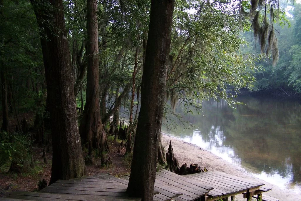
A 15-minute walk along the boardwalk will take you to a dock overlooking the Edisto River. You can also press on and take the 1.5-mile loop trail that can be completed in about an hour. It will transport you from the wetlands to higher upland forest area. Make sure to wear appropriate shoes. The trail may be muddy, and the roots can make the trek challenging. Also, the boardwalk narrows when traveling through the old phosphate pits. Be sure to bring bug spray if you come in the spring or summer.
Bring a picnic and blanket if you want to enjoy lunch on the dock overlooking the Edisto River. Bring along the camera so you can capture the beauty of the area’s flora and fauna. Relax and watch the river flowing gracefully. Look carefully and you just might see an alligator or two.
See what our visitors love about the
SOUTH CAROLINA LOWCOUNTRY
Use the #hashtag #sclowcountry to get your image featured!
The Lowcountry & Resort Islands Region of South Carolina includes the four, southern-most counties in the state, Beaufort, Jasper, Hampton, and Colleton, which are bordered on the east by the Atlantic Ocean and on the west by the Savannah River and the state of Georgia.
So happy that “Clouds Gather” has found its forever home. 💖 I hope this painting brings joy and memories of happy times to the new owners. #partagergallerygiftsandhome #acrylicpainting #SCLowcountry #southcarolina
This painting conveys a moment I captured of our son during one of our family beach walks, as we looked for nature’s treasures at low tide. He had broken his arm at the beginning of summer and wasn’t able to participate in his favorite summer activities such as sports and jumping waves in the ocean. As a parent, it was difficult watching him miss out, but I was constantly amazed at his positivity and resilience. Watching him in this moment made me think about how we are always searching and the many places our life’s journey takes us.
Discover at your own leisure at the coastaldiscoverymuseum 🌳 From century-old buildings with storied pasts, to wooden boardwalks that stretch into the Jarvis Creek salt marsh, there`s always something to explore!
Details ✨ • I love the perspective of this first shot. I know the angle isn’t a normal view, if you had this hung in your house, but I just think it’s so badass and cool and it’s my account so I can post it and y’all will just have to deal 😆😜. But really, thanks for all the love you’ve shown me on this piece so far. I’m really proud of it and can’t wait to make more versions of this design. 💙🌾 • Fiber sources tagged 🌊
Spanish moss drapes the live oak trees that are ubiquitous to the Edisto Island area. Did you know that Edisto gets its name from the native Edistow people? The Edistow Native Americans were a sub tribe of the Cusabo indians, a group of Native Americans who lived along the Atlantic coast in South Carolina.
⏰ Best time of the day to visit: Stop by mid-morning. That way you can explore the island, grab lunch, and stay for the amazing sunset if you choose.
🏖️ Things to do while there: Edisto Environmental Learning Center, Boneyard Beach, Scott Creek Inlet, Big Bay Creek, SeaCow Eatery.
☀️ Things to visit in the area: Jungle Road Park, Bay Creek Park, Otter Islands, Spanish Mount Point.
📆 Best time of the year to visit: For warmer weather come anywhere from March-August.
🏨 Where to stay: Fripp Island Golf & Beach Resort (frippislandrsrt), Seabrook Island Club (seabrook_sc), The Sanctuary at Kiawah Island Golf Resort (kiawahresort), Charleston Kiawah Island/Andell Inn (andellinn).
A visitor takes a leisurely stroke under a canopy of live oaks draped with Spanish moss in the Palmetto Bluff (palmettobluff) neighborhood of Bluffton, South Carolina. Palmetto Bluff is a picturesque community that sits in the heart of Lowcountry. Nestled along the May River, it’s abundant with beautiful walking trails, historic sites, and stunning views.
⏰ Best time of the day to visit: There is no wrong time to visit Palmetto Bluff. However, we highly recommend sticking around for one of their spectacular sunsets.
🛶 Things to do while there: Stop by Cole’s for some regionally inspired Southern fare, paddle board, kayak, or canoe along the May River, go saltwater fishing, take a tour at Bluffton Jack`s Old Town Tours.
🌊 Things to visit in the area: Palmetto Bluff Conservancy, Old Town Bluffton, Bluffton Oyster Factory Park, May River Sandbar, Heyward House Museum and Welcome Center (heywardhouse).
📆 Best time of the year to visit: For the best weather, we recommend visiting between March and May or from September to November.
🏨 Where to stay: The Montage Palmetto Bluff Resort (montagepalmettobluff) is the only resort in Palmetto Bluff. However, there are plenty of places to stay in the surrounding areas including: Old Town Bluffton Inn (oldtownblufftoninn), The Inn & Club at Harbour Town (theinnandclubatharbourtown), Sonesta Resort Hilton Head Island (sonestahhi).
Isn`t this live oak tree tunnel beautiful? Live oak, draped in Spanish moss, is emblematic of South Carolina and many of the Southern states. We love these iconic trees, not only for their beauty, but their history as well. The average lifespan of a live oak is 300 years!
The shore gently recedes beneath the stunning Pawleys Island Pier. The unique island town, located about 25 miles south of Myrtle Beach and 70 miles north of Charleston, exudes laid-back, beachy vibes. Locals have definitely adopted an island state of mind and encourage visitors to as well. When you go, make sure to relax on the beach, explore the famous sand dunes, or fish in one of the many adjacent creeks.
⏰ Best time of the day to visit: We guarantee that you’re going to want to spend a whole day here. We recommend getting to the beach at around 10am.
🗓️ Best time of the year: Pawleys Island has the best weather during the spring and early summer months.
🏖️ Things to do while there: Pawleys Island Nature Park, Pawleys Island Chapel, Hopsewee Plantation.
🐠 Things to visit in the area: Brookgreen Gardens (brookgreen_gardens), take a walking ghost tour, Myrtle Beach (mymyrtlebeach), Harborwalk Marina, South Carolina Maritime Museum (southcarolinamaritimemuseum).
🏨 Where to stay: The Oceanfront Litchfield Inn (oceanfrontlitchfieldinn), Litchfield Beach and Golf Resort (litchfieldbeachandgolf), Sea View Inn (seaviewinn), 620 Prince (620prince).
Pregnancy sleep = 😫. Silver lining, a sunrise walk with Sullie and Zoey. _ Anyone else deal with terrible sleep in the third trimester? It`s been brutal. Combo of overall anxiety/mind racing, digestion discomfort and having to pee all the time! 😐 _ #sunrise #follybeach #sclowcountry #scbeaches #goldenretrievers #goldensofinstagram #charleston #29weekspregnant #thirdtrimester #pregnancylife #pregnancyproblems #beach #beachsunrise
Angel Oak, Johns Island, South Carolina. ⠀ ⠀ The Angel Oak Tree is a Southern live oak (Quercus virginiana) located in Angel Oak Park on Johns Island near Charleston, South Carolina. The Angel Oak Tree is estimated to be at least 400 and possibly up to 1400 years old It stands 66.5 ft (20 m) tall, measures 28 ft (8.5 m) in circumference, and produces shade that covers 17,200 square feet (1,600 m2). Its longest branch distance is 187 ft. in length. ⠀ ⠀ #angeloak #angeloaktree #southcarolina #johnsisland #charleston #DiscoverSC #lowcountry #SCLowcountry #lowcountrylife #igerssouthcarolina #blackandwhite #b&w #oaktree #legacyoak #blackandwhite #blackandwhitephotography #totravelistolive #travel_captures #travellove #travelpics #travelpic #travelbug #travelandlife #lifeisajourney #adventuroussoul
The South Carolina Lowcountry Guidebook is filled with many things to see and do in the beautiful Lowcountry of South Carolina. Please fill out the information and we will send you a FREE GUIDE BOOK.


