Park rangers share their knowledge at the park’s visitor center. Photo by the Post & Courier.
Did you know Beaufort was home to the Reconstruction Era National Historical Park? It is only fitting that it is found in Beaufort, because that is where freedom from slavery began in the south! The Emancipation Proclamation was first read in the South on January 1, 1863, at Camp Saxton, just a stone’s throw away from Beaufort in Port Royal. During the Civil War the US military occupied Beaufort as a command center for east coast operations. Many of the historic homes and churches were used as offices, hospitals, and quarters. Many churches were converted into schools for the newly freed. Some of these homes were bought by former slaves at tax auctions.
Park rangers lead tours at the Penn Center’s Darrah Hall. Photo by Jenny Kendrick.
The Reconstruction Era lasted from 1861 to 1877. During this important time four million newly freed African Americans sought to integrate themselves into a free society. They contributed to the educational, economic, and political life of Beaufort. This process began as the Port Royal Experiment. After the Battle of Port Royal more than 10,000 slaves were left behind when the white population fled the area. Schools were established to teach reading, writing, and other life skills. Many joined the US Army and trained at Camp Saxton, the very place where they heard the Emancipation Proclamation.
The Reconstruction Era National Historical Park is comprised of three main locations, along with three park partners that aid in telling the story of the Port Royal Experiment, which helped formerly enslaved people become self-sufficient. In addition to being a group of historic sites in and around Beaufort, it tells the story of what happened after the Civil War as newly freed African Americans and the nation struggled toward reconciliation. The park consists of historic sites that were instrumental in the Reconstruction Era of Beaufort. Penn Center’s Darrah Hall and Brick Baptist Church on St. Helena Island, Camp Saxton and the Pinckney-Porters Chapel in Port Royal join the Old Beaufort Firehouse to tell the story of Reconstruction.
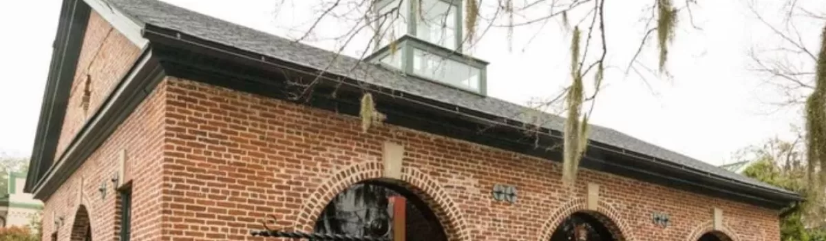
Reconstruction Era National Monument visitor center images by Cosmos Mariner and Trip Bucket.
The Reconstruction Era National Historical Park Visitor Center can be found in the Old Beaufort Firehouse, 706 Craven Street. The visitor center contains displays and artwork that depict the struggle of the formerly enslaved people and their ascension to citizenship. The center also houses information about the other sites and their importance in the history.
Darrah Hall then and now. Images by Penn Center and Chris Bloomfield.Fingerprints can still be seen in the bricks of Brick Baptist Church. Photos by Jenny Kendrick and Michael Miller.
Darrah Hall and the Brick Baptist Church can be found on the grounds of St. Helena Island’s Penn Center. The Penn School was established in 1862 as the first school in the south for former slaves. Quaker and Unitarian missionaries from Pennsylvania founded the school and taught classes. Early classes were held in the Brick Baptist Church, which was built in 1855 by the very slaves that would later learn to read and write within its walls. Careful examination of the bricks reveals handprints from the enslaved artists who formed the bricks from clay.
Darrah Hall image by Charleston Currents.
Darrah Hall is the oldest building on the campus of the Penn Center. It was built by Penn School specifically for community use. It has been a gathering place for the community for over 100 years. This building, along with others on the property represents the development of the center through the 19th and 20th centuries. The hall is used for interpretive purposes by the park, as well as for community events.
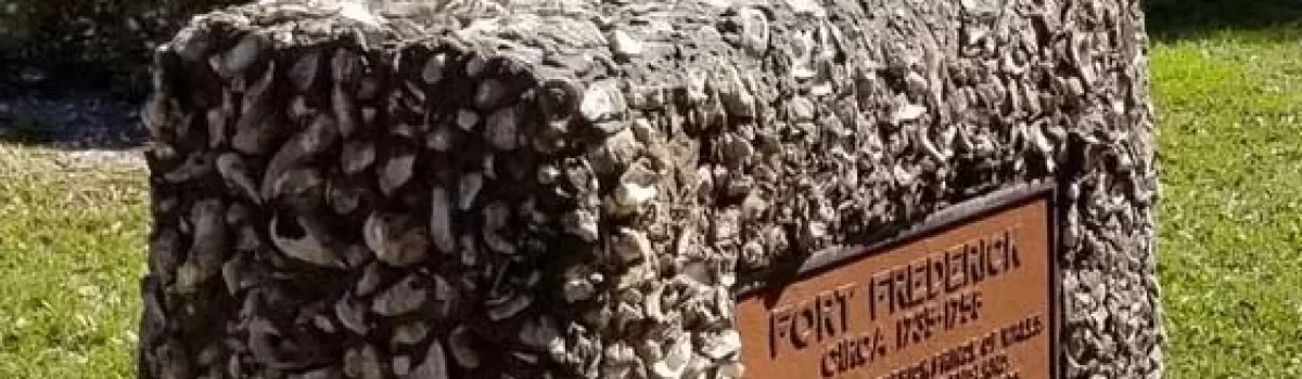
Camp Saxton was founded on the site of Fort Frederick, a pre-Revolutionary War fort that was abandoned and absorbed into Smith Plantation. On New Year’s Day in 1863, the Emancipation Proclamation was read aloud here to 10,000 former slaves. After the Proclamation was read, the 1st South Carolina Volunteers was formed. This all-black regiment trained at Camp Saxton from 1862 to 1863. The site is preserved as the Fort Frederick Heritage Preserve. The tabby fort was originally built by the British in the 1730s. During the Civil War a bridge was built across its walls to serve as a dock to welcome former slaves to the reading of the Emancipation Proclamation.
The Pinckney-Porters Chapel was moved down the street and restored in the Naval Heritage Park of Port Royal.Photos by Island News and Carmen Pinckney.
Pinckney Porter Chapel is a Reconstruction-Era Freedman’s Chapel that was restored and moved to Port Royal’s Naval Heritage Park. The chapel houses temporary exhibits and Camp Saxton programs begin at the site. The chapel is, in part, named for Senator Clemente Pinckney who served as pastor to the church from 1996-1998. Senator Pinckney was gunned down while serving as a pastor for Charleston’s Mother Emanuel AME Church in 2015. Pinckney was a beloved native of Ridgeland and served as a South Carolina state senator for Beaufort County. The chapel is open on Saturday mornings and park rangers are available to answer questions.
Reconstruction Era National Historical Park Visitor Center – 706 Craven Street, Beaufort Brick Baptist Church – 85 Martin Luther King Drive, St Helena Island Darrah Hall & Penn Center – 16 Penn Center Cir E, St Helena Island Camp Saxton – 601 Old Fort Road, Port Royal Pinckney-Porters Chapel – Naval Heritage Park, Pinckney Street, Port Royal
This image celebrated Emancipation Day as it was seen at Beaufort’s Ft. Frederick, also known as Camp Saxton.
The Port Royal Experiment started just seven months after the first shots of the Civil War were heard. Beaufort and its sea islands were occupied by the Union Army by November 7, 1861, thus freeing its slaves. Beaufort quickly became the epicenter for Reconstruction after Confederate soldiers and plantation owners fled the area, leaving 200 sea island plantations and 10,000 slaves abandoned. Having no resources or direction, former slaves looked to the Union Army for support. Union officials oversaw the harvesting of approximately 90,000 pounds of cotton by the newly freed men and women. Workers were paid $1 for every 400 pounds harvested. This was the first time newly freed slaves earned wages for their hard work. Frederick Law Olmstead was the executive secretary of the US Sanitary Commission. He felt it was necessary for the Union to, “Train or educate them in a few simple, essential, and fundamental social duties of free men in civilized life.” Olmstead was a famous landscape architect who would go on to design Central Park, Niagara Reservation at Niagara Falls, Biltmore Estate, and many other prestigious grounds. The Port Royal Experiment was an essential plan that offered newly freed slaves an education and a chance to work and live independently of white control. The freedmen’s Bureau was established to help former slaves succeed in their new way of life.
At the suggestion of General Sherman, the US Congress confiscated a strip of coastal land from Charleston to Florida. President Abraham Lincoln issued new land distribution policies that saw 40,000 acres of this land divided between freed families. They were allowed to purchase up to 40 acres of land for $1.25 per acre. Excess army mules were redistributed to the new property owners. It is thought that this was the origin of the slogan “40 acres and a mule.” White northerners were also allowed to buy land, creating tenant farming.
Hilton Head Island’s Fish Hall Plantation became the site of Mitchelville. This image was taken in 1862 by Henry Moore.
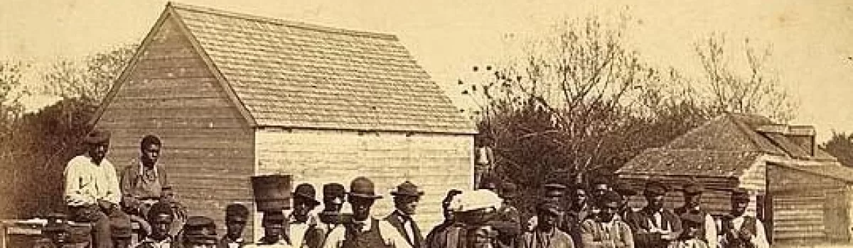
By January of 1862 Union General Thomas W. Sherman requested teachers to instruct the freed men, women, and children. Later that year, the Port Royal Experiment began. This radical program created schools and hospitals for the freedmen. It also allowed them to purchase and run abandoned plantations. 53 missionaries from the New England Freedmen’s Aid Society volunteered during this humanitarian crisis. Skilled teachers, ministers and doctors travelled south to teach life skills and religious studies. Two pivotal initiatives that paved the way for Reconstruction were begun in the Lowcountry – Mitchelville and Penn School.
Freedmen gather at Penn School to learn to read and write along with other skills.
Laura Towne was dispatched from Pennsylvania with funds to create the Penn School, one of the largest schools created during the experiment. She and fellow educator Ellen Murray established an educational mission on St. Helena Island called Penn School. This was the first school for former slaves of the sea islands. The first classes were held at Oak Plantation, then when enrollment increased, they moved to Brick Church. A school was built adjacent to the church and a complex developed around it which served as a center for the St. Helena Island Gullah community. Along with teaching literacy, the school provided training for midwives, a health care clinic, and the state’s first day care center for black children.
Rev. Jesse Jackson; Joan Baez; Ira Sandperl; Dr. Martin Luther King, Jr.; and Dora McDonald on the Penn Center campus in 1964. Photo credit: Bob Fitch
The Penn Center took on a new role during the Civil Rights Movement of the 1960s. In those days there were only a handful of safe havens for black leaders to gather. Civil Rights activists, including Martin Luther King, Jr. spent a significant amount of time on the Penn Center campus. Dr. King and other influential civil rights activists were able to meet and strategize on the beautiful campus. The spot also served as a retreat for the Southern Christian Leadership Conference. The Penn Center campus was designated a National Historic Monument in 1974. The center is still a vital part of the community. History and culture are preserved in the center’s museum, outreach programs and educational experiences.
The community of Mitchelville was planned and built in 1862.
The wartime Department of the South was headquartered on Hilton Head Island. Union General Ormsby Mitchel granted Hilton Head freedmen permission to develop the town of Mitchelville in 1862. This was the creation of the first all-black, self-governing community in the country. Government and missionary efforts provided blacks of Mitchelville with education, religion and promoted self-reliance. While learning new skills, the citizens of Mitchelville were able to thrive and continue their Gullah customs and culture. By 1865 Mitchelville had 1,500 inhabitants. They built the First African Baptist Church. Homes were built on quarter-acre lots, where the new inhabitants could grow produce in their own gardens. General Mitchel died from yellow fever, just six weeks after arriving in Mitchelville.
Freedwomen and children began a new way of life in Mitchelville.
Mitchelville became a fully functioning town, complete with a mayor, councilmen, a treasurer, and other officers who oversaw every aspect of the town. The town boasted three churches, two schools, a store, cotton gin and grist mill. Mitchelville also passed the first compulsory education law in the state, requiring all children between 6 and 15 to be educated in school. The town stretched over 200 acres along the shore of the Atlantic. The major source of employment was the US Army Headquarters. After the war, jobs disappeared with the withdrawal of the US Army. This sent freedmen away from Mitchelville in pursuit of employment. The property that Mitchelville occupied was returned to the previous owners during the Johnson administration. They chose to sell the land to anyone that was interested in purchasing, including former Mitchelville citizens. Most of the land was bought by Freedman March Gardner. The land was later divided amongst heirs and the town no longer appeared on maps by the early 20th century. Most of the land was eventually sold to the Hilton Head Company and placed on the National Register of Historic Places in 1988. The site is preserved as the Historic Mitchelville Freedom Park. The park serves as a Reconstruction Era heritage site. The park features exhibits, signature events and guided tours.
Freedmen harvest cotton.
The death of Abraham Lincoln on April 15,1865 ended the momentum for the Port Royal Experiment. President Andrew Johnson worked to restore all lands to their previous owners. Many freedmen that bought land witnessed it returned to its former owners. Sharecropping quickly began to creep onto the scene. Not all black landowners lost their land. Many were able to retain ownership of their purchased properties because they were not reclaimed by the previous owners. By 1868, the Freedmen’s Bureau was completely dismantled. Momentum for the Port Royal Experiment began to diminish with the new administration. The Reconstruction Era ended in 1877. Although it was a brief period in American history, it marked a significant chapter in the history of civil rights in the United States.
The date was January 1, 1863, when former enslaved Beaufortonians crossed over into Fort Frederick from Port Royal, Beaufort, and the surrounding sea islands to hear the first reading of the Emancipation Proclamation in the southern states. This event marked the most dynamic occurrence in the fort’s 289-year history.
Image found on Fort Frederick Heritage Preserve website.View of Fort Frederick from the river. Photo by Carmen Pinckney.
Fort Frederick was built by the British colonial government between 1733 and 1735. It is the oldest surviving tabby fort in South Carolina and the oldest tabby structure in Beaufort County. Tabby was a building material used in the early days of the coastal south. Sand, lime, oyster shells and water were burned and mixed to form an early version of concrete. Tabby was poured into molds to form foundations, walls, columns, and blocks. Examples of tabby can still be seen all throughout the historic district of Beaufort. Even the city’s sea wall is made from tabby.
Images by Carmen Pinckney.
Fort Frederick was established after the Yemassee War in Port Royal to protect against possible attacks by the Spanish. It also served as an outpost to signal “Beaufort Town” of approaching ships. The fort remained active until 1758. The small 75-ft by 125 ft fort contained barracks, a powder magazine and gun platforms. It was located along the Beaufort River behind a parapet with a battery of guns protecting the river and town of Beaufort.
A bridge to freedom was constructed over the walls to Fort Frederick for a celebratory reading of the Emancipation Proclamation.
British Regulars were posted at the fort, but luckily never saw attack. A larger, stronger fort was established just upriver, and Fort Frederick was abandoned. The deserted fort fell into disrepair and wouldn’t see use again until 1861. Union Colonel Thomas Wentworth Higginson brought activity back to the fort site after the Battle of Port Royal. After the historic reading of the Emancipation Proclamation, newly freed citizens were given the opportunity to enlist in the Union Army. He and his new regiment of black soldiers used the property as headquarters. The site was named Camp Saxon, after General Rufus Saxon, commander of the Beaufort District.
Images by Carmen Pinckney.
Before the start of the Civil War, Fort Frederick was absorbed into the Smith Plantation. Parts of the tabby structure were used as a dock for boats serving the plantation. During Beaufort’s “Great Skedaddle” Smith’s Plantation was abandoned, and the Union troops moved in. Colonel Higginson and his new soldiers would become the African American 1st South Carolina Regiment of Volunteers. Together they listened to the first reading of the Emancipation in the center of a crowd which was estimated well into the thousands. In 1863 the fort and its surrounding plantation land were sold for non-payment of $93.40 in back taxes. The US government purchased the property for $1,000.00. Part of this site was developed into the US Naval Hospital in 1949.
Image from the SC Department of Natural Resources.
Archaeologists with the South Carolina Department of Natural Resources and the Institute of Anthropology and Archaeology at the University of South Carolina excavated the site in 2014 to inventory the grounds. They also rebuilt the remaining tabby walls to give visitors a more complete image of what the fort once looked like. This work also protected the remaining tabby material. A portion of the structure is underwater today due to the river changing course.
Images by Carmen Pinckney.
The South Carolina Department of Natural Resources and Beaufort County now maintain the area as the Fort Frederick Heritage Preserve. The six-acre park is a mix of hardwood forest, maritime forest, and salt marshes on the Beaufort River. Located at 601 Old Fort Road in Port Royal, the preserve is open to the public daily, from dawn to dusk. The preserve includes a public access point, parking area and picnic pavilion, as well as the tabby fort ruins.
Auldbrass view toward the pool. Image by Anthony Peres.
Nestled amongst the live oaks and cypress swamps of the Combahee River sits a unique treasure. Hidden from passersby, this lovely jewel is only open for tours one weekend, every other year. The legendary architect Frank Lloyd Wright designed only one plantation during his legendary career. Luckily for us, it sits just outside the town of Yemassee.
Image by CBS Sunday Morning.
“Auldbrass” was established in 1938. Over 4,000 acres from Old Brass, Mount Alexander, Richfield, Old Combahee, and Charlton plantations were combined and given to C. Leigh Stevens (from Michigan) for reorganizing the Savannah River Lumber Company. In 1939 Stevens commissioned Wright to envision and design a self-sufficient, modern plantation for farming, hunting and entertaining. Wright called on his principles of organic architecture to design a complex that would exist in harmony with its surrounding Lowcountry landscape. Wright, not being a fan of the more traditional right angle, designed walls to slope at an 80 degree, to mimic the live oaks on the property. He also looked to the property’s cypress trees for inspiration for exterior siding. Wright named this complex Auldbrass.
Image found on Pinterest.
Initial drawings and plans of the house and complex were finished by 1940. Hexagonal shapes and inward sloping walls, with low lying ceilings were the theme. By 1941 the farm buildings were nearly completed, and the main house was in the beginning stages. Work was halted in 1942 due to World War II and shortages of supplies.
An example of the copper Spanish moss-inspired downspout can be found near the pool. Image by Ed Forgotson.
Wright’s plans included a low-lying complex of geometric pavilions, outbuildings, stables and kennels. The main house was supplemented with multiple guest cottages and service quarters. Plans also included a swimming pool, laundry, and bath houses for the staff. Decorative motifs inspired by local flora compliment the design. A great example of this can be seen in the down spouts designed to resemble Spanish moss. The downspouts were not realized until the 1980s because WWII caused a shortage of building materials. By 1946 Stevens was ready to resume construction. He moved into the completed caretaker’s cottage to oversee construction. Very little was done between 1946-1948 because Stevens began guest lecturing at Harvard Business School. Frank Lloyd Wright died in 1959, the Stevens followed in 1962. Neither saw the project completed.
Image found on the Island Packet.
Stevens’ daughter Jessica Loring took over ownership of Auldbrass in 1971. She and her husband managed the estate and produced corn and soybeans. They made extensive repairs to the buildings with their profits. They also replaced the roof, upgraded the mechanical systems and eliminated changes made to Wright’s original designs. By this time visitors became curious about the plantation. Jessica and her husband welcomed them in and gave tours. The Lorings also did something very important for the property. They nominated Auldbrass for the National Register of Historic Places. By 1979 the Lorings were ready to sell the property.
Image by Anthony Peres.
The cost of upkeep was more than they were able to accomplish. The Boise Cascade Timber Company purchased the property, except the Old Combahee tract, which they retained for themselves. Westvaco quickly bought the property, selling the buildings and a small tract of land to local hunters. Unfortunately, they could not manage the buildings and they quickly fell into disrepair. Beaufort County Open Land Trust became involved with the property. It was decided to place an easement on the property and sell at a drastically reduced price.
Bluebird Cottage image by Ed Forgotson.
Hollywood producer Joel Silver purchased the property in 1987. Silver had long been a fan of Wright’s architecture. He lives in the Storer House in Los Angeles, which was designed by Wright and built in 1923. Silver enlisted the help of Eric Lloyd Wright, grandson of the designer. Together they set out to restore the buildings on the property and complete Wright’s vision. His plan has four stages: restore all original buildings as designed, rebuild destroyed buildings, complete unbuilt projects, and add structures needed by Silver, mimicking Wright’s style. Silver and his team have spent the last 35 years realizing this dream.
Shades of rust and brown help the structures blend in naturally with their surroundings. The low-lying, rambling main house feels like a hunting lodge, complete with all the trappings of comfort. The symmetry that is so prevalent in traditional plantation homes has been cast aside for this one-story, sprawling home. In fact, all buildings on the property are one level and no single grand drive leads to the house.
Even the windows join in on the geometric fun! Image by Ed Forgotson.
Visitors to Auldbrass will have to look hard to find a right angle in Wright’s buildings. Staff quarters, barn, guest cottages, and even the pool and hot tub all have an abundance of obtuse and acute angles. While the windows are squared, their panes are not.
Interior image by Anthony Peres.
Geometry is at play in the interior of Auldbrass as well. The wall angles and windowpane designs are much more visible inside. Even the furniture was designed by Wright, with the same design principles. Much of the furniture had to be replaced when Silver restored the plantation, but as luck would have it, the purchase came complete with Wright’s original blueprints for the plantation structures and furniture designs. The home is currently furnished as Wright envisioned it.
Beaufort Open Land Trust image of the livingroom.
There’s only one way visitors can tour this beautiful plantation. Every two years the Beaufort Open Land Trust schedules tours for one weekend. For more information visit BeaufortOpenLandTrustfor more information. For more information about other sights to see in the Yemassee area visit YemasseeDrivingTour.
Location: Combahee River, 7 River Road in Yemassee East of Yemassee on River Road, Beaufort County.
A special thank you to Gayle Kovach for suggesting we share a story on this iconic Lowcountry treasure, and for enjoying the Driving Detour Through Yemassee blog.
Even the Auldbrass dock on the Combahee River shares the same design principles. Photo by Carmen Pinckney
Image from Frampton Plantations reenactment of the Battle of Pocotaligo.
The Battle of Pocotaligo was an American Civil War Battle fought on October 22, 1862. Union troops sailed up the Broad River and landed at Mackay Point. They proceeded inland across creeks, swamps fields of cotton and potatoes. Along the way they met Rebel forces and battery fire at Frampton Plantation.
Image from Frampton Plantations reenactment of the Battle of Pocotaligo.
“The (Pocotaligo) Expedition was designed to accomplish the following objectives: First, to make a complete reconnaissance of the Broad River and its three tributaries, Coosawhatchie, Tullifiny, and Pocotaligo; second, to test practically the rapidity and safety with which a landing could be effected; third, to learn the strength of the enemy on the main-land, now guarding the Charleston and Savannah Railroad; and fourth, to accomplish the destruction of so much of the (rail)road as could be effected in one day. At this season of the year I did not deem it prudent to expose the troops upon the main-land for a longer period” (October is hurricane season) – Major General O. M. Mitchel, Commander of the Federal Department of the South
Image from Route of the Expedition October 22, 1862 map, U.S. National Archives and Records Administration.Modern graphics added by SC Lowcountry Tourism Commission for clarification purposes.
The ultimate goal of the Union Army at Pocotaligo was to destroy the Pocotaligo River railroad bridge and cut communication wires. If accomplished, this act would cut off supplies, Rebel reinforcements and communication between the two cities. Scouts and spies were sent along with a group of freed blacks. They set out to examine boat landings, measure water depth and cut the telegraph wires.
Union Brigadier General John M. BrannanUnion Boat Captain Robert Smalls
Major General Mitchel ordered Union troops to sail up the Broad River and land at the mouth of the Pocotaligo River, at MacKay’s Point. Major General Mitchel fell ill and handed over command to Brigadier General John M. Brannan. They started sailing at 12:30 am. Upon landing around 6 am, Union troops disembarked with horses and guns. They began marching up the MacKay Point Road by 10 am. They were heading to the old town of Pocotaligo, just seven miles away. One of the boats used was the Planter, a previous Confederate ship that was liberated by Robert Smalls, a former slave from Beaufort. (He had just recently sailed the ship past Confederate forces in Charleston and handed over control of the ship to the Union Army. He joined the Union Army and became the captain of the very boat he liberated.)
Confederate Colonel William S WalkerConfederate Captain Stephen Elliot
Colonel William S Walker was the Confederate Commander responsible for defending the Charleston to Savannah Railroad. He received word by 9 am that the enemy was landing in force, from twelve gunboats and transports. Union troops were also ascending the Coosawhatchie River with four transports. Confederate troops were immediately ordered to march to Old Pocotaligo. Both sides engaged in combat all along the road inland, from 11:30 am to 6 pm.
Upon landing at MacKay’s Point, Union forces were met with tough terrain. The area was wooded and swampy. This made transport of heavy artillery challenging. Once the Union forces were out of reach from the gunboat artillery, the Confederate forces attacked at Caston’s Plantation. The terrain provided a natural barrier to aid in their defenses. A battery of dead trees from Frampton Plantation was also set up as a defense. Confederate field artillery was placed on either side of the road. This sent Union forces to cross an open field and open causeway.
According to Union officer Col. Good, “We scoured the woods, and after four hours of the most fatiguing labor I ever performed we came to an open space. It is no child’s play to go through the woods of South Carolina. They are one interminable growth of small shrubs, briars, and swamps. Our faces and hands were torn badly, in some cases, while our clothes suffered more. Again we pushed forward through a field with weeds higher than our heads. This terminated in a cotton field, where the riflemen of the enemy were posted, and then flanked by another dense wood. In this open field the battle opened “
Captain Stephen Elliot was in command of the Beaufort Light Artillery, stationed between Frampton land and Mackay’s Point. He reported, “A little before 12, I opened on their (Union) advancing line in Uncle George’s corn field with two howitzers supported by half a company of infantry and some calvary. We continued to fire until they moved within two hundred and fifty yards of us when we limbered up, crossed over a bridge and opened with one gun.”
From The Battle of Pocotaligo, South Carolina, Lewis G. Schmidt, 1993.
Union forces advanced to Frampton Creek by 1 pm. There were two positions occupied by Confederate soldiers on the property. The first position was south of the swamp at the sweet potato field. The second was just north at the causeway near the corn and cotton fields. The swamp was unpassable at this point and passage could only be reached by the causeway. They spent the next hour and a half in tough battle on the property.
Close-up image from Route of the Expedition October 22, 1862 map, U.S. National Archives and Records Administration.
Colonel Good of the Union Forces 1st Brigade reported, “We proceeded but little more than a mile when a battery opened upon us from the Frampton Plantation. Here, as the rebels had a great advantage of position, ensconced in a wood with a deep swamp in front, passable only by a narrow causeway, the bridge of which had been destroyed, we had a large number killed and wounded. …In front of the stream is a strip of woods about five hundred yards wide, and in front of the woods a marsh of about two hundred yards, with a small stream running through it, parallel with the woods. A causeway also extends across the swamp, and on the right of it the swamp is impassable. Here the enemy opened a terrible fire of shell from the rear of the woods.”
Colonel Good goes on to describe the landscape of the low-lying Frampton Plantation, “On our side of the swamp and along the entire front and flanks of the enemy (extending to the swamp), was an impervious thicket, intersected by a deep-water ditch, and passable only by a narrow road…We found the rebels posted in a small wood with infantry and artillery. A ditch fronted the woods, then came an open cotton field. Line of battle was formed, and skirmishers were called in.”
Image from Frampton Plantations reenactment of the Battle of Pocotaligo.
“Here, protected by the trees and the thick brush, and having in their favor all the advantages of the ground and road across the marsh. Our artillery was placed this side the marsh in a potato field; the infantry in the woods in front…This road ran through a sweet potato field covered with vines and brush.”
Image from Frampton Plantations reenactment of the Battle of Pocotaligo.
The second position at Frampton Plantation was very costly for the Union forces. Elias Bryant of the 4th New Hampshire wrote the Rebels “Made a stand at a bridge which they tore up after them. When we got there, we took the front and the 6th Connecticut the rear. The bridge being flanked on both sides, it was almost impossible to cross and here took place considerable of a fight, in which we lost pretty heavily.”
Image from Frampton Plantations reenactment of the Battle of Pocotaligo.
By 1:30pm the Union Army’s Second Brigade joined the First, pushing rebel forces into the marsh. This inflicted serious damage on the Confederate batteries. Many rebel gunners were killed, but sharp shooters were positioned to pick off Union soldiers. Heavy artillery fire from the Union soldiers persisted as they made repairs to the destroyed bridge. They quickly advanced and debated ways to pass through the next swamp and avoid the Rebel sharpshooters. Cannon fire from howitzers was aimed into the trees to dislodge the sharp shooters, and the Union Army advanced once again.
Image from Frampton Plantations reenactment of the Battle of Pocotaligo.
According to Adrian Terry of the 7th Connecticut, “We had no means of estimating their force except from the weight of their fire but think that is could not have been less than two thousand, the position which they occupied making this number fully equal to any which we could bring against them. The fight at this point and indeed until the latter part of the day was almost entirely one of artillery, our infantry lying down in line of battle ready to act at a moment’s warning and the artillery gradually driving the enemy from one strong position to another until he reached Pocotaligo Creek.”
From The Battle of Pocotaligo, South Carolina, Lewis G. Schmidt, 1993.
By 3pm the Union forces had pushed the Confederates back to where the Mackay Point Road met the Coosawhatchie Road (King’s Highway). They further pushed them across the Pocotaligo Bridge, which they destroyed after crossing to prevent the Union soldiers from crossing. The creek was deep, and the banks were boggy, which made an impassable ditch. The Rebel army retreated to a heavy battery that was positioned on high ground. The Rebels were protected by an earthwork and one piece of light artillery. “While retreating they kept up a brisk and continuous firing, taking advantage of every good position for their artillery while their sharp-shooters, protected by the trees and their knowledge of the ground, kept up an irregular, but harassing fire of musketry.” Capt. Gobin, 47th Pennsylvania.
Image from Frampton Plantations reenactment of the Battle of Pocotaligo.
The Union soldiers were happy that the Rebels destroyed the Pocotaligo Bridge, as that was one of their goals. The supply line road between Savannah and Charleston had been cut. Once the Rebels retreated further the Union soldiers began cutting trees to bridge the river. Rebels continued to fire upon the Union army. The Charleston and Savannah Train whistle could be heard, bringing Rebel reinforcements. “Timber for the purpose of rebuilding this bridge was prepared by the Engineers and was ready to be put together when the retreat was ordered.” Reported Colonel Edward Serrell, Union Engineer. The Union Army, now completely without ammunition, retreated to Mackay Point and their gunboats. The Rebels were unable to follow the eight Union regiments because their numbers were around 250. The sun was also due to set. Confederate Captain Stephen Elliot wrote to his wife the following day, “God has mercifully protected your husband. Half of yesterday was passed in a shower of bullets. How any of the artillery escaped is almost a miracle for the trees under which we fired are thickly studded with bullets.“
Image from Frampton Plantations reenactment of the Battle of Pocotaligo.
According to Union Colonel Bell, “At about five o’clock Lieutenant Colonel Sleeper of the 4th New Hampshire, received the order to retire. We fought ‘til after supper, eating while lying in the woods preparing for the retreat. Our regiment was last to leave as rear guard to bury the dead and bring in the wounded…We buried them in their blankets under the trees. We followed the retreat by four ranks carrying dead officers and the wounded in blankets…and on stretchers for seven miles.”
Image from Frampton Plantations reenactment of the Battle of Pocotaligo.
Sunset occurred at around 5:20pm that day. The fight had lasted from 1 o’clock to nearly six o’clock. According to the History of the First Light Battery Connecticut Volunteers, “Our men fought splendidly. Most of the fighting was through swamps and in cotton fields. Several times they got into mud so deep they had to help one another out.” By 7pm the Rebel forces were headed back across the Pocotaligo River towards Frampton land. Along the way, Confederate soldiers found all the supplies that had been shed by Union soldiers on their pursuit through the marsh. Overcoats, haversacks, canteens, hats, shoes, ammunition, chests, cartridge boxes, and bayonets were scattered across the path. The Tri-Weekly Watchman October 27, 1862, edition reported, “The abolition troops in their retreat, left the ground strewn with excellent knapsacks, filled with Yankee notions of various kinds. They also threw aside large numbers of carefully prepared fagots, to be used for incendiary purposes.” As they retreated towards Mackay Point, they also destroyed a bridge so Confederate forces could not pursue them in their retreat. Union soldiers also managed to cut the telegraph lines during their campaign. The lines were repaired, and communication was restored the following day.
Image from Frampton Plantations reenactment of the Battle of Pocotaligo.
By 8pm the Union troops made their way back to Frampton property, their first battle ground of the day. Colonel Goode reported, “Here my regiment was relieved of rear-guard duty by the 4th New Hampshire Regiment. This gave me the desired opportunity to carry my dead and wounded from the field and convey them back to the landing.” By 11pm the troops were boarding ships. The rear guard did not clear the fields until midnight and made their way back to the boats by morning.
Captain William Elliot of the Beaufort Light Artillery reported, “I slept the night of the fight upon their battleground and there were twenty-two Union dead in bisquit throw of me, it was amazing how indifferent we were to their being dead. Captain Hamilton and myself took a dead fellow’s haversack and cooked his pork upon the hot coals and ate our breakfast at four o’clock in the morning. It was very good too.” The Confederate forces did not pursue Union troops. A reconnaissance was made to Mackay Point, and it was discovered that the Union troops had abandoned the mainland. By the 24th, the gunboats had disappeared.
The Battle of Pocotaligo From Frank Leslie’s Illustrated Newspaper, October 21, 1862.
According to the S. F. Dupont letters from October 23, 1862, “We have gained a victory, but at a fearful cost. The expedition did not result in the material success which was hoped for it; but of our troops, who crowded on shipboard, many were deprived of rest, who marched the next day ten miles and fought the enemy six hours; who returned hungry, thirsty, worn and weary, and today are busily re-embarking, I think too much cannot be said in praise. They have answered the most ardent expectations of their commanders.”
At the conclusion of the battle, Union casualties were 61 killed, 276 wounded and 6 missing. Confederates reported 21 killed, 124 wounded and 18 missing. (Official Records Army, Vol. 14, Chap. XXVI, Page 148.)
Although the first three objectives were met, the Union troops did not make it to the railroad on this particular day. Reconnaissance of the Broad River and its tributaries was completed, boat landings were effected on those tributaries and intelligence was gathered on the strength of the enemy on the mainland. The Union Army could not make it to the railroad to destroy the tracks. The area of Pocotaligo would fall to Union control on January 15, 1865. The 17th Corps with General Sherman and the black infantry regiment of the 54th Massachusetts advanced across the Lowcountry. Frampton Plantation houses would also be burned at this time. Not much evidence can be seen today that reminds us of what happened in our backyard, so long ago. There is one tell-tale sign that is still visible. The “Frampton Line” earthworks were raised on this site by General Robert E. Lee’s troops in 1962. This 100-yard fortification was a fall-back position from which to defend the Charleston to Savannah Railroad. While not as visible today as it once was, it is labeled on the “Map of the Rebel Lines of the Pocotaligo, Combahee and Asheepoo” used during the Civil War. It can be seen just behind the Frampton House that was rebuilt in 1886. Google Maps show the earthworks as it extends deep into the woods.
Arial view above the current Frampton House showing what’s left of the earthworks behind the house. Visitors can view this in the backyard.
Sources:
The Pocotaligo Expedition, Robert McNair, 1997 The Battle of Pocotaligo, South Carolina, Lewis G. Schmidt, 1993
Image from Rise and Shine, Only On Good Morning America.
The morning crew of Good Morning America spent some time in the South Carolina Lowcountry focusing their attention on the rich Gullah culture of the Beaufort sea islands. According to the Gullah Geechie Corridor website, “The Gullah Geechee people are descendants of Africans who were enslaved on the rice, indigo and Sea Island cotton plantations of the lower Atlantic coast. Many came from the rice-growing region of West Africa. The nature of their enslavement on isolated island and coastal plantations created a unique culture with deep African retentions that are clearly visible in the Gullah Geechee people’s distinctive arts, crafts, foodways, music, and language.” The ancestors of the Gullah Geechie people of the Lowcountry continue the traditions of their forefathers and celebrate their rich heritage on a daily basis.
Image of Kenneth Moton and Mary LeGree from GMA3.
University of South Carolina graduate and Good Morning America reporter Kenneth Moton spent time with Beaufort natives Mary Rivers LeGree, Victoria Smalls and Anita Singleton Prather. Mary Rivers LeGree is a native of St Helena Island. She lives on land purchased by her ancestors during Reconstruction. Her roots are deep in the Gullah community. She is protector of the Coffin Point Praise House, which sits not too far from her home. She is also the voice for Gullah Culture at the Beaufort Visitors Center, where she educates tourists about her rich heritage. Concerned Gullah Geechie traditions will fade away with the younger generations, Mary LeGree wants places like the Coffin Point Community Praise House to be a source of inspiration to educate and preserve a culture that helped build a nation.
Image of Victoria Smalls and Kenneth Moton from GMA3.
Victoria Smalls is the executive director of the Gullah Geechie Cultural Heritage Corridor. This area spans the Atlantic coastline from North Carolina to Florida. She shared the story of Beaufort hero Robert Smalls. He was one of the first African Americans to serve in congress. After the Civil War, this Gullah statesman purchased the property where he was formerly a slave. He advocated for black land ownership. Victoria Smalls shared her ancestors purchased 20 acres after the war and it has been handed down over the years.
Image of Gullah Gullah Island from GMA3.
Gullah culture became well known during the 1990s with the production of Nickelodeon’s Gullah Gullah Island, starring St. Helena Island’s own Ron and Natalie Daise, along with their children. The tv show explained the rich and pure culture. Since then, many shows have aired that show the rich heritage of the Gullah Geechie culture, including a recent Netflix episode of “High on the Hog: How African American Cuisine Transformed America”.
Image of Anita Singleton Prather from Rise and Shine, Only On Good Morning America.
From the sanctuary of the Beaufort Tabernacle Baptist Church, Gullah storyteller Anita Singleton Prather spoke of the importance of the Gullah culture as a culture of survival. She spoke of it “…as a trophy of perseverance…of people that went through horrible things, and could have been completely wiped out, but not only die we survive, but we continued to thrive…We’re still here.”
Come over to beautiful Beaufort, SC to shop, dine, dance, play and socialize.
Life is like a box of chocolates and you never know who you’ll see at Beaufort’s First Friday event!
The historic town of Beaufort is big on tradition and social gathering. This Lowcountry town has dedicated a special day each month for just such occasions. Come over to Beaufort on the First Friday of every month. Bay Street will be closed to traffic in the evening so people can gather and have a good time. The shops are unique, the food is divine and the people are one-of-a-kind! Experience southern hospitality in the heart of the Lowcountry!
Holidays are especially fun at First Friday.
First Friday is a celebration of Downtown shops, restaurants, cultural venues, and community. It’s a fun night for the downtown businesses and for locals! Come explore downtown galleries, shopping, and eateries throughout the evening. Bay Street is closed to vehicle traffic from 5-8 p.m. Enjoy entertainment and live demonstrations too! The event is free and open to all ages.
The downtown stores always stay open late for First Friday!
Downtown shops are always open late for this monthly event.
December’s First Friday kicks off Beaufort’s Holiday Weekend. This fun three-day event includes Night on the Town, a lighted boat parade and Christmas parade. Be sure to add this to your calendar of events.
Dancing on the street is always a big event at Beaufort’s First Friday events!
Beaufort’s First Friday is always a highly anticipated monthly event.
The Port Royal Farmers Market sets up in the Naval Heritage Park every Saturday, from 9-12. You will find a vast selection of fresh, local and seasonal produce, along with shrimp, oysters, poultry, beef, pork, eggs, bread and cheese.
If you’re lucky Carolina Kidz will be there with a Nigerian Dwarf Goat to pet. They provide a wonderful selection of raw goat’s milk, drinkable yogurt, goat cheese; chevre, ricotta & feta and goat cheese cheesecake.
Daise Produce, along with many other produce vendors will be on hand with a large selection of farm fresh goodies. Come early for the best selections.
Shoppers will also find plants, ferns, camellias, azaleas, citrus trees, and beautiful, fresh cut flower bouquets.
Check out the prepared food vendors serving; BBQ, dumplings, she crab soup, crab cakes, paella, coffee, baked goods, bagels and breakfast sandwiches.
Come hungry and have coffee and a breakfast sandwich while you peruse the vendors. Make sure to bring your market basket so you can fill it with local goodies. For a list of vendors and a description of their products visit the Port Royal Farmers Market Website. For a complete list of Lowcountry farmers markets and the days they are open, visit SouthCarolinaLowcountry.com/farmersmarkets.
Port Royal Farmers Market at Naval Heritage Park Ribault Road and Pinckney Street. Open every Saturday from 9 to 12.
If you are in the vicinity of Bluffton on any given Thursday afternoon, you should find your way to the Bluffton Farmers Market. Located in the heart of Old Town Bluffton, the market has something for everyone. The market is teaming with fresh produce, sweets, prepared foods, fresh pasta, dog treats and much, much more.
Park the car and have lunch at one of the many restaurants that are just steps away. Lunch can also be purchased at the market and taken to the Heyward House where tables are set up around a backyard fire pit.
Don’t miss the opportunity to browse the many unique stores in the area after visiting the market booths. Most shops are housed in restored structures along Calhoun Street and its intersections. Converse with shop owners and view their one-of-a-kind items.
The Bluffton Farmers Market is open every Thursday from, 12-5 p.m. – Year-Round. Farm Fresh Produce to includes strawberries, carrots, onions, spinach, varieties of lettuce, broccoli, mushrooms, beets, potatoes, just to name a few… and honey, eggs, cheese, herbs, plants, flowers, seafood, and anything else in season. Prepared foods include BBQ, crepes, empanadas, gumbo, fried oysters & shrimp, she crab soup, crab cakes, fresh baked pastries & breads, sweets, coffee, kettle corn, chocolates, and much more…
Don’t forget your furry friends. Dogs are welcome at the farmers market and in most of the stores and restaurants in the area. Bring Fido for lunch and if he behaves, stop by the doggie booth and pick up some treats!
Bluffton Farmers Market Martin Family Park 68 Boundary Street at the intersection of Green St. Bluffton, SC 29910 843-415-2447
March is upon us and so are all the festivities that come with it! The Lowcountry is busy with festivals and activities to keep us entertained all month.
Bluffton will be starting off the month’s festivities with the inaugural Bluffton Night Bazaar held under the twinkling lights of the Burnt Church Distillery courtyard. This new monthly event features local artisans, live music, food & drink.
The Beaufort Charities Oyster Roast is just a few days away, on March 5th at Live Oaks Park in Port Royal. In its 17th year, the Oyster Roast features all you can eat Beaufort oysters from 1-8 pm. Entertainment will be provided by local bands The Entertainers and Steel Rail Express. The event also includes premium micro-brews, a full day children’s program, live auctions, and local vendors offering varied fairs.
Walterboro is excited to announce the return of the Walterboro History, Arts & Music Festival. This festival celebrates local history along with visual and performing arts added into the mix. Artists, performers, reenactors, storytellers, musicians and more entertain the crowds that come from near and far. The festival will be held in various locations throughout Walterboro, March 7-12.
The Beaufort History Museum will host two Revolutionary War events March 11-12, 2022, as part of its anticipation of the 250th anniversary of the war in 2026. On Friday, March 11, 2:00-3:00 p.m., at the St. Helena Island Public Library, 6355 Jonathan Francis Sr. Rd., Rita Elliott will discuss the Battle of Purrysburg, S.C., and later archaeological dig discoveries made at the battle site. On Saturday, March 12, 10:00 a.m.-4:00 p.m., at the Beaufort History Museum, 713 Craven St., re-enactors from the 5th Company, 4th South Carolina Regiment will conduct a live-fire demonstration with period artillery. The team will be set up in the walled Arsenal Courtyard and provide a unique educational opportunity for visitors of all ages. Live cannon demonstrations are planned at 30-minute intervals throughout the day starting at 10:30 AM. Both events are free and open to the public.
Dust off your green because the Hilton Head Island St. Patrick’s Day Celebration is BACK!! It’s time to turn out for South Carolina’s oldest St Patrick’s Day Parade. Kick off your St. Patrick’s Day Celebration on Hilton Head Island during the 27th Annual Pinnacle Bank Hilton Head Shamrock 5K. Hilton Head’s Annual “Running of the Green” will be held on Saturday morning March 12th at 7:30am.
Next on the agenda is the Hilton Head St. Patrick’s Day Weekend. Come view the 2nd Annual Boat Parade as it cruises down Broad Creek, followed by an Irish concert at Lowcountry Celebration Park. The parade is the grand finale! It will proudly march down Pope Avenue Sunday, March 13th at 3pm.
Join Beaufort March 12th in historic downtown as they celebrate St. Patrick’s Day in a fun way! The Sham Rocked Sip & Stroll 2022 offers several ticket options from 10am – 2pm. Each attendee receives a Sip & Stroll t-shirt, swag bag, and access to all the goodie stations spread throughout downtown Beaufort. Goodie stations will feature either a cocktail, something yummy or something swag for you to have during your stroll. Downtown merchants will be open for shopping during or after the stroll. Restaurants will be featuring lunch and dinner specials as well! So grab your gal pals, friends, family, or significant other for a fun filled day in downtown Beaufort during the Sip & Stroll!
Soak up some local culture at Hardeeville’s Lowcountry Pow Wow and Cultural Festival March 12-13th. Millstone Landing is the backdrop for this festival that sets out to educate the public about Native Americans. It also creates a gathering place for Native people to celebrate their culture. The event features Aztec dancing, drumming, arts & crafts, native campsites, demonstrations, food and much more.
Beaufort’s Town Center will be the site for their Annual St. Patrick’s Day Festival. This outdoor event will showcase a variety of wholesome activities for people of all ages. The 4th Annual St. Patrick’s Day Festival at Beaufort Town Center is a free, family-fun celebration benefiting the Beaufort Area Hospitality Association. The event will take place on Saturday, March 19 from 12-4pm. Area restaurants and food trucks will be selling food and drinks and there will be live entertainment including a bagpipe player, local music, and much more! This family-fun event will have activities for all ages! We will also have festive drinks available for the adults!
The Hilton Head Wine & Food Festival takes place the last week of March. This week-long celebration combines the fruits of global wine partnerships, signature Lowcountry cuisine, grassroots cultural happenings, and the authentic fabric of a unique community. Join us as we celebrate the 36th anniversary of this annual Hilton Head Island rite of passage. Experience for yourself this year’s schedule of events including spectacular celebrity chef showcases, intriguing wine education sessions, live entertainment and of course the famed Grand and Public Tasting events.
See what our visitors love about the
SOUTH CAROLINA LOWCOUNTRY
Use the #hashtag #sclowcountry to get your image featured!
The Lowcountry & Resort Islands Region of South Carolina includes the four, southern-most counties in the state, Beaufort, Jasper, Hampton, and Colleton, which are bordered on the east by the Atlantic Ocean and on the west by the Savannah River and the state of Georgia.
So happy that “Clouds Gather” has found its forever home. 💖 I hope this painting brings joy and memories of happy times to the new owners. #partagergallerygiftsandhome #acrylicpainting #SCLowcountry #southcarolina
This painting conveys a moment I captured of our son during one of our family beach walks, as we looked for nature’s treasures at low tide. He had broken his arm at the beginning of summer and wasn’t able to participate in his favorite summer activities such as sports and jumping waves in the ocean. As a parent, it was difficult watching him miss out, but I was constantly amazed at his positivity and resilience. Watching him in this moment made me think about how we are always searching and the many places our life’s journey takes us.
Discover at your own leisure at the coastaldiscoverymuseum 🌳 From century-old buildings with storied pasts, to wooden boardwalks that stretch into the Jarvis Creek salt marsh, there`s always something to explore!
Details ✨ • I love the perspective of this first shot. I know the angle isn’t a normal view, if you had this hung in your house, but I just think it’s so badass and cool and it’s my account so I can post it and y’all will just have to deal 😆😜. But really, thanks for all the love you’ve shown me on this piece so far. I’m really proud of it and can’t wait to make more versions of this design. 💙🌾 • Fiber sources tagged 🌊
Spanish moss drapes the live oak trees that are ubiquitous to the Edisto Island area. Did you know that Edisto gets its name from the native Edistow people? The Edistow Native Americans were a sub tribe of the Cusabo indians, a group of Native Americans who lived along the Atlantic coast in South Carolina.
⏰ Best time of the day to visit: Stop by mid-morning. That way you can explore the island, grab lunch, and stay for the amazing sunset if you choose.
🏖️ Things to do while there: Edisto Environmental Learning Center, Boneyard Beach, Scott Creek Inlet, Big Bay Creek, SeaCow Eatery.
☀️ Things to visit in the area: Jungle Road Park, Bay Creek Park, Otter Islands, Spanish Mount Point.
📆 Best time of the year to visit: For warmer weather come anywhere from March-August.
🏨 Where to stay: Fripp Island Golf & Beach Resort (frippislandrsrt), Seabrook Island Club (seabrook_sc), The Sanctuary at Kiawah Island Golf Resort (kiawahresort), Charleston Kiawah Island/Andell Inn (andellinn).
A visitor takes a leisurely stroke under a canopy of live oaks draped with Spanish moss in the Palmetto Bluff (palmettobluff) neighborhood of Bluffton, South Carolina. Palmetto Bluff is a picturesque community that sits in the heart of Lowcountry. Nestled along the May River, it’s abundant with beautiful walking trails, historic sites, and stunning views.
⏰ Best time of the day to visit: There is no wrong time to visit Palmetto Bluff. However, we highly recommend sticking around for one of their spectacular sunsets.
🛶 Things to do while there: Stop by Cole’s for some regionally inspired Southern fare, paddle board, kayak, or canoe along the May River, go saltwater fishing, take a tour at Bluffton Jack`s Old Town Tours.
🌊 Things to visit in the area: Palmetto Bluff Conservancy, Old Town Bluffton, Bluffton Oyster Factory Park, May River Sandbar, Heyward House Museum and Welcome Center (heywardhouse).
📆 Best time of the year to visit: For the best weather, we recommend visiting between March and May or from September to November.
🏨 Where to stay: The Montage Palmetto Bluff Resort (montagepalmettobluff) is the only resort in Palmetto Bluff. However, there are plenty of places to stay in the surrounding areas including: Old Town Bluffton Inn (oldtownblufftoninn), The Inn & Club at Harbour Town (theinnandclubatharbourtown), Sonesta Resort Hilton Head Island (sonestahhi).
Isn`t this live oak tree tunnel beautiful? Live oak, draped in Spanish moss, is emblematic of South Carolina and many of the Southern states. We love these iconic trees, not only for their beauty, but their history as well. The average lifespan of a live oak is 300 years!
The shore gently recedes beneath the stunning Pawleys Island Pier. The unique island town, located about 25 miles south of Myrtle Beach and 70 miles north of Charleston, exudes laid-back, beachy vibes. Locals have definitely adopted an island state of mind and encourage visitors to as well. When you go, make sure to relax on the beach, explore the famous sand dunes, or fish in one of the many adjacent creeks.
⏰ Best time of the day to visit: We guarantee that you’re going to want to spend a whole day here. We recommend getting to the beach at around 10am.
🗓️ Best time of the year: Pawleys Island has the best weather during the spring and early summer months.
🏖️ Things to do while there: Pawleys Island Nature Park, Pawleys Island Chapel, Hopsewee Plantation.
🐠 Things to visit in the area: Brookgreen Gardens (brookgreen_gardens), take a walking ghost tour, Myrtle Beach (mymyrtlebeach), Harborwalk Marina, South Carolina Maritime Museum (southcarolinamaritimemuseum).
🏨 Where to stay: The Oceanfront Litchfield Inn (oceanfrontlitchfieldinn), Litchfield Beach and Golf Resort (litchfieldbeachandgolf), Sea View Inn (seaviewinn), 620 Prince (620prince).
Pregnancy sleep = 😫. Silver lining, a sunrise walk with Sullie and Zoey. _ Anyone else deal with terrible sleep in the third trimester? It`s been brutal. Combo of overall anxiety/mind racing, digestion discomfort and having to pee all the time! 😐 _ #sunrise #follybeach #sclowcountry #scbeaches #goldenretrievers #goldensofinstagram #charleston #29weekspregnant #thirdtrimester #pregnancylife #pregnancyproblems #beach #beachsunrise
Angel Oak, Johns Island, South Carolina. ⠀ ⠀ The Angel Oak Tree is a Southern live oak (Quercus virginiana) located in Angel Oak Park on Johns Island near Charleston, South Carolina. The Angel Oak Tree is estimated to be at least 400 and possibly up to 1400 years old It stands 66.5 ft (20 m) tall, measures 28 ft (8.5 m) in circumference, and produces shade that covers 17,200 square feet (1,600 m2). Its longest branch distance is 187 ft. in length. ⠀ ⠀ #angeloak #angeloaktree #southcarolina #johnsisland #charleston #DiscoverSC #lowcountry #SCLowcountry #lowcountrylife #igerssouthcarolina #blackandwhite #b&w #oaktree #legacyoak #blackandwhite #blackandwhitephotography #totravelistolive #travel_captures #travellove #travelpics #travelpic #travelbug #travelandlife #lifeisajourney #adventuroussoul
The South Carolina Lowcountry Guidebook is filled with many things to see and do in the beautiful Lowcountry of South Carolina. Please fill out the information and we will send you a FREE GUIDE BOOK.


