
Fall is the perfect time for a camping trip to the South Carolina Lowcountry.
Fall temperatures in the South Carolina Lowcountry are perfect for spending time in nature. The cool mornings, mild days and campfire-worthy evenings are ideal for camping. Spending time outdoors is a wonderful way to escape the grind and recharge the batteries!

Is summer heat too much for you? Do mosquitoes and no-see-ums send you running for the door? Fall is the perfect time for you! Reservations are easier to find after Labor Day when schools are back in session. Temperatures cool, humidity drops, and pesky biting insects begin to disappear.

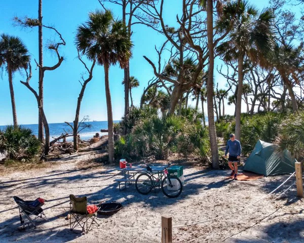
Image by SC Lowcountry Tourism Commission.
Three state parks in the Lowcountry have camping facilities. Private campgrounds are also located across the area. While some are designed as destinations, others are perfect for a short stop during a long haul. Campgrounds located along I-95 are great for using as a hub to visit all the major attractions across the Lowcountry.

Image by SC Lowcountry Tourism Commission.
Beaufort County
Hunting Island State Park is the South Carolina’s most popular state park. The campground is located at the northern end of the island. The campground has 100 campsites with water and electrical hookups, shower and restroom facilities, beach walkways and a playground.

Image by Bigfoot Search Party. 
Image by Cruise America. 
Image by the Dyrt.


Enjoy the many miles of walking trails that wind throughout the park. Climb the state’s only publicly accessible lighthouse. Ascend the 167 steps for a panoramic view 130 feet above the beach and maritime forest. The park also has a fishing pier and visitors can borrow gear from the Nature Center.


Hunting Island State Park camping reservations must be made for a minimum of two nights. To make a camping reservation or view current rates, call toll-free 1-866-345-7275, or visit our reservations page by clicking here. Rates vary by season and demand and are subject to change. The campground is pet-friendly, but there are restrictions.
2555 Sea Island Pkwy., Hunting Island, SC 29920
Tuc in the Wood Campground and RV Park is located not too far away on St. Helena Island, one of the Lowcountry’s most beautiful islands. The campground has 80 RV and tent sites with water and electrical hookups. There’s also a bathhouse with hot showers and restroom facilities.


Cast your line in the stocked, freshwater fishing pond. Visit nearby Penn Center, Chapel of Ease, and Fort Fremont. Travel 12 miles to Hunting Island State Park or drive to downtown Beaufort. Cable TV hookup and Wi-Fi are available. The campground is also pet-friendly. Make your reservations by calling 843-838-2267. Questions and inquiries can be emailed to tuckinthewood@islc.net


Hilton Head Harbor RV Resort & Marina is a luxury RV resort located on the north end of Hilton Head Island. The 200-site waterfront, pet friendly resort offers landscaped sites with concrete pads, excellent dining, top-notch amenities, on-site water sports activities and more. The resort has two swimming pools, hot tubs, sun deck, gazebo, saunas, and tennis courts.


The on-site marina is the perfect spot to book water sports including jet skis, kayaks, paddle boards, dolphin tours and more. Fish on the pier or launch your boat from the ramp. The property also boasts a 5-Star restaurant. Call 843-681-3256 or visit Hilton Head Harbor RV Resort & Marina for more information. 43 Jenkins Rd, Hilton Head Island, SC


Hilton Head Island Motorcoach Resort is a luxury camping destination located on the south end of the island. Guests are provided with the ultimate getaway experience. 400 spacious and charming sites are available to accommodate most motorcoach needs, with full hook-ups, cable TV, Wi-Fi, and excellent amenities. The Resort has spots available to rent or own, including scenic lake front sites, private shaded forest sites, and clubhouse sites that place you steps away from the excitement. The resort is located just one mile from beaches, popular restaurants, and unique shops.


The resort offers an array of amenities including a pool, spa, tennis courts, pickleball courts, dog park and full laundry facilities. Between area attractions and resort events, you’ll always have something fun to do during your stay. Call 843-785-7699 or visit Hilton Head Island Motorcoach Resort for more information. 133 Arrow Road, Hilton Head Island, SC


Colleton County
Edisto Beach State Park has both oceanfront and salt marsh camp sites. There are 112 sites with water and electrical hookups. Tent campers can choose a site with hookups or a more rustic site at the park’s Live Oak Campground. All sites are conveniently located close to public restrooms with hot showers. The park also has furnished cabins that sit nestled in the woods. The Edisto Beach State Park Campground is pet friendly, but dogs are not allowed in the cabins or cabin area. Dogs must be always kept on a leash. Fishing is allowed along the ocean or salt marsh. Flounder, whiting, spot tail bass and other saltwater fish can be caught in the park. A boat ramp and dock can be found at the park for fishing in Big Bay Creek.


On warm fall days, spend the day at the beach. Walk along the surf to search for seashells and shark’s teeth. Hike, bike or bird watch along the trails, beach, and maritime forest. The trails are comprised of a series of short, mostly level paths that wind through Edisto Island’s maritime forest of live oak, hanging Spanish moss, and palmetto trees. During your walk you may see white-tailed deer, osprey, or alligators, and may even catch a glimpse of the wary bobcats. To make a camping reservation or view current rates, call toll-free 1-866-345-7275 or visit the reservations page by clicking here. Rates vary by season and demand and are subject to change. Camping reservations must be made for a minimum of two nights. 8377 State Cabin Rd, Edisto Island, SC


Colleton State Park is a paddler’s paradise This Lowcountry park sits a short distance from I-95 and connects to Givhan’s Ferry State Park via 23 miles of blackwater river. Colleton State Park provides easy access to the Edisto River, one of the longest free flowing, blackwater rivers in the country, and serves as the headquarters for the Edisto River canoe and kayak trail. Other amenities at Colleton include an easy nature trail, a campground, picnic shelters and ballfields. The main roads at the park and in the campground are paved.


Each site is packed sand and has individual water and electrical hookups. Some sites accommodate RVs up to 40 feet, others up to 25 feet. The campground is convenient to restrooms with hot showers. To make a camping reservation or view current rates, call toll-free 1-866-345-7275 or visit our reservations page by clicking here. Rates vary by season and demand and are subject to change. Camping reservations must be made for a minimum of two nights. 147 Wayside Lane, Walterboro, SC


If you are a true adventurer and want to get off the grid for a while, grab a canoe from Carolina Heritage Outfitters and paddle to your very own treehouse. Located on the halfway point along a 23-mile canoe trip, the Carolina Heritage Outfitters Treehouses are truly off the beaten path. Camp in style with no electricity. Oil candles and tiki torches light the night. Use the propane stove or grill to prepare your meals. The only running water you’re going to find here is in the river. Bring a cooler of provisions to put in the furnished kitchen. Bring a sleeping bag to place on the bed. An outhouse is provided for your convenience.


Meet the team in the morning to shuttle upriver. Paddle 13 miles to your treehouse. Each treehouse is constructed of local materials and tucked away along the riverbank. Swim in the river. Hike the woodland trails. Then warm yourself by the fire pit. After a good night’s rest, paddle the remaining 10 miles to finish off the trip at the outpost. While on the river, be on the lookout for Great blue herons, owls, egrets, wood storks, pileated woodpeckers, wood ducks, wild turkey, deer, muskrats and raccoon. Visit Carolina Heritage Outfitters website or call 843-563-5051 for more information. 1 Livery Lane, St. George, SC


New Green Acres is a full featured campground, able to accommodate the full range of RV dimensions or types. This is a great place to pull in and spend the night while on the way to other adventures. The campground is located on I-95 and has 106 sites with the longest and widest pull-thru sites east of the Mississippi. Water and electrical hook-ups are available, as well as cable and wireless internet.


Cool off in the swimming pool. Take the kids to the playground or play with your furry friend in the dog park. Visit New Green Acres website or call 843-538-3450, 800-474-3450 for more information or to book a stay.
396 Campground Road, Walterboro, SC 29488


Givhan’s Ferry State Park is a natural retreat in the Lowcountry woods. The park sits at the end of the 23-mile long stretch of Edisto River kayaking paradise known as the Edisto River kayak and canoe trail that begins at Colleton State Park. The Edisto River is the longest free-flowing blackwater river in North America. Rent a cabin, bring an RV or tent to this beautiful state park. Full-service camping sites are available with water and electrical hookup. Some sites are hike in only. They are also complete with water and electricity. Grills, fire pits, picnic tables and storage boxes are provided at each site. Clean restrooms with hot showers are centrally located. Hike the trails or bring a kayak and explore the river.


To make a camping reservation call toll-free 1-866-345-7275 or visit our reservations page by clicking here. Rates vary by season and demand and are subject to change.
Camping reservations must be made for a minimum of two nights. Pets are not allowed in the cabins or the cabin areas. Pets are allowed in most other outdoor areas provided they are kept under physical restraint or on a leash not longer than six feet. 746 Givhans Ferry Road, Ridgeville, SC


Jasper County
Come to the Point South KOA. Unwind at this 5 star retreat located conveniently just off I-95, near Savannah, Charleston, Hilton Head and Beaufort. Visitors have the choice of RV, tent, or cabin sites. Explore the estates, museums, and beaches of the Lowcountry. You may even choose to stay on site and enjoy the many amenities and serene setting. Glamp in a fully stocked deluxe lodge. Some are even crafted from authentic railroad cars! Enjoy this walk in, walk out experience in place of a hotel. Family fun begins as you check in and check out our activities, like gem mining, backpacks to color, as well as kerchiefs for the pups, a large pool and good old-fashioned fun with tether ball, corn hole, horseshoes, life size chess set and Jenga game at the expanded playground.


There is a large dog walk plus a Kamp K9 for our 4-legged friends. Unwind with a glass of wine from regional wineries. Our newest addition is our own crafted beer from a local brewery. Our own Aria’s Ale is on tap at our full-line Swimming Mermaid Coffee House, which has a full selection of custom roast coffees, latte’s, iced coffees, hot tea and more. Relax and enjoy made-to-order pizza and wings, delivered to your site. Unwind in our Coffee House & wine bar, where we feature a full line of locally roasted coffees as well as a full array of wines. Book reservations by visiting koa.com. Call 843-726-5733 or 800-562-2948 for more information.


Experience the beauty, relaxation, and the perks of nature at The Oaks at Point South RV Resort. Within 45 minutes of this Lowcountry RV camp, you’ll find attractions like Hilton Head, historic Savannah, Georgia, and the Atlantic Ocean. This campground also boasts a convenient location near Interstate 95, allowing guests to enjoy everything the South Carolina Lowcountry has to offer.


Back at the resort, guests can look forward to an array of activities. Test your hand at mini golf, go for a swim, enjoy fishing, or hit the trails for a hike. Fall activities include Halloween trick or treating and a Thanksgiving potluck. They’re pet friendly as well, so don’t forget your four-legged friends! Call 843-726-5728, or 1-800-388-7788 or visit thousandtrails.com for more information and to book reservations. 1292 Campground Road, Yemassee, SC


Camp Lake Jasper is conveniently located just minutes off of Interstate 95 at Exit 8 in Hardeeville. This brand new resort is convenient to Hilton Head and the historic cities of Bluffton, Beaufort and Savannah. Wake to the sounds of nature beckoning you to explore the park. Hike the pristine trails, paddle the clear waters, play the challenging “Sarge” disc golf course, or simply relax in the lakeside pool and amenity center. Do as much or as little as you like.


Spend the day golfing, shopping, dining, or enjoying the beach and then return for a relaxing night by the campfire. Whether its adventure you seek or escaping the hustle and bustle of everyday life, Camp Lake Jasper is the place for you. Reserve your site today and let the memories begin. 44 Camp Lake Drive, Hardeeville, SC


For more information about the South Carolina Lowcountry visit SouthCarolinaLowcountry.com.


