
October 21-23, 1862

The Battle of Pocotaligo was an American Civil War Battle fought on October 22, 1862. Union troops sailed up the Broad River and landed at Mackay Point. They proceeded inland across creeks, swamps fields of cotton and potatoes. Along the way they met Rebel forces and battery fire at Frampton Plantation.

“The (Pocotaligo) Expedition was designed to accomplish the following objectives: First, to make a complete reconnaissance of the Broad River and its three tributaries, Coosawhatchie, Tullifiny, and Pocotaligo; second, to test practically the rapidity and safety with which a landing could be effected; third, to learn the strength of the enemy on the main-land, now guarding the Charleston and Savannah Railroad; and fourth, to accomplish the destruction of so much of the (rail)road as could be effected in one day. At this season of the year I did not deem it prudent to expose the troops upon the main-land for a longer period” (October is hurricane season) – Major General O. M. Mitchel, Commander of the Federal Department of the South

The ultimate goal of the Union Army at Pocotaligo was to destroy the Pocotaligo River railroad bridge and cut communication wires. If accomplished, this act would cut off supplies, Rebel reinforcements and communication between the two cities. Scouts and spies were sent along with a group of freed blacks. They set out to examine boat landings, measure water depth and cut the telegraph wires.


Major General Mitchel ordered Union troops to sail up the Broad River and land at the mouth of the Pocotaligo River, at MacKay’s Point. Major General Mitchel fell ill and handed over command to Brigadier General John M. Brannan. They started sailing at 12:30 am. Upon landing around 6 am, Union troops disembarked with horses and guns. They began marching up the MacKay Point Road by 10 am. They were heading to the old town of Pocotaligo, just seven miles away. One of the boats used was the Planter, a previous Confederate ship that was liberated by Robert Smalls, a former slave from Beaufort. (He had just recently sailed the ship past Confederate forces in Charleston and handed over control of the ship to the Union Army. He joined the Union Army and became the captain of the very boat he liberated.)


Colonel William S Walker was the Confederate Commander responsible for defending the Charleston to Savannah Railroad. He received word by 9 am that the enemy was landing in force, from twelve gunboats and transports. Union troops were also ascending the Coosawhatchie River with four transports. Confederate troops were immediately ordered to march to Old Pocotaligo. Both sides engaged in combat all along the road inland, from 11:30 am to 6 pm.
Upon landing at MacKay’s Point, Union forces were met with tough terrain. The area was wooded and swampy. This made transport of heavy artillery challenging. Once the Union forces were out of reach from the gunboat artillery, the Confederate forces attacked at Caston’s Plantation. The terrain provided a natural barrier to aid in their defenses. A battery of dead trees from Frampton Plantation was also set up as a defense. Confederate field artillery was placed on either side of the road. This sent Union forces to cross an open field and open causeway.
According to Union officer Col. Good, “We scoured the woods, and after four hours of the most fatiguing labor I ever performed we came to an open space. It is no child’s play to go through the woods of South Carolina. They are one interminable growth of small shrubs, briars, and swamps. Our faces and hands were torn badly, in some cases, while our clothes suffered more. Again we pushed forward through a field with weeds higher than our heads. This terminated in a cotton field, where the riflemen of the enemy were posted, and then flanked by another dense wood. In this open field the battle opened “
Captain Stephen Elliot was in command of the Beaufort Light Artillery, stationed between Frampton land and Mackay’s Point. He reported, “A little before 12, I opened on their (Union) advancing line in Uncle George’s corn field with two howitzers supported by half a company of infantry and some calvary. We continued to fire until they moved within two hundred and fifty yards of us when we limbered up, crossed over a bridge and opened with one gun.”

Union forces advanced to Frampton Creek by 1 pm. There were two positions occupied by Confederate soldiers on the property. The first position was south of the swamp at the sweet potato field. The second was just north at the causeway near the corn and cotton fields. The swamp was unpassable at this point and passage could only be reached by the causeway. They spent the next hour and a half in tough battle on the property.

Colonel Good of the Union Forces 1st Brigade reported, “We proceeded but little more than a mile when a battery opened upon us from the Frampton Plantation. Here, as the rebels had a great advantage of position, ensconced in a wood with a deep swamp in front, passable only by a narrow causeway, the bridge of which had been destroyed, we had a large number killed and wounded. …In front of the stream is a strip of woods about five hundred yards wide, and in front of the woods a marsh of about two hundred yards, with a small stream running through it, parallel with the woods. A causeway also extends across the swamp, and on the right of it the swamp is impassable. Here the enemy opened a terrible fire of shell from the rear of the woods.”
Colonel Good goes on to describe the landscape of the low-lying Frampton Plantation, “On our side of the swamp and along the entire front and flanks of the enemy (extending to the swamp), was an impervious thicket, intersected by a deep-water ditch, and passable only by a narrow road…We found the rebels posted in a small wood with infantry and artillery. A ditch fronted the woods, then came an open cotton field. Line of battle was formed, and skirmishers were called in.”

“Here, protected by the trees and the thick brush, and having in their favor all the advantages of the ground and road across the marsh. Our artillery was placed this side the marsh in a potato field; the infantry in the woods in front…This road ran through a sweet potato field covered with vines and brush.”

The second position at Frampton Plantation was very costly for the Union forces. Elias Bryant of the 4th New Hampshire wrote the Rebels “Made a stand at a bridge which they tore up after them. When we got there, we took the front and the 6th Connecticut the rear. The bridge being flanked on both sides, it was almost impossible to cross and here took place considerable of a fight, in which we lost pretty heavily.”

By 1:30pm the Union Army’s Second Brigade joined the First, pushing rebel forces into the marsh. This inflicted serious damage on the Confederate batteries. Many rebel gunners were killed, but sharp shooters were positioned to pick off Union soldiers. Heavy artillery fire from the Union soldiers persisted as they made repairs to the destroyed bridge. They quickly advanced and debated ways to pass through the next swamp and avoid the Rebel sharpshooters. Cannon fire from howitzers was aimed into the trees to dislodge the sharp shooters, and the Union Army advanced once again.

According to Adrian Terry of the 7th Connecticut, “We had no means of estimating their force except from the weight of their fire but think that is could not have been less than two thousand, the position which they occupied making this number fully equal to any which we could bring against them. The fight at this point and indeed until the latter part of the day was almost entirely one of artillery, our infantry lying down in line of battle ready to act at a moment’s warning and the artillery gradually driving the enemy from one strong position to another until he reached Pocotaligo Creek.”

By 3pm the Union forces had pushed the Confederates back to where the Mackay Point Road met the Coosawhatchie Road (King’s Highway). They further pushed them across the Pocotaligo Bridge, which they destroyed after crossing to prevent the Union soldiers from crossing. The creek was deep, and the banks were boggy, which made an impassable ditch. The Rebel army retreated to a heavy battery that was positioned on high ground. The Rebels were protected by an earthwork and one piece of light artillery. “While retreating they kept up a brisk and continuous firing, taking advantage of every good position for their artillery while their sharp-shooters, protected by the trees and their knowledge of the ground, kept up an irregular, but harassing fire of musketry.” Capt. Gobin, 47th Pennsylvania.

The Union soldiers were happy that the Rebels destroyed the Pocotaligo Bridge, as that was one of their goals. The supply line road between Savannah and Charleston had been cut. Once the Rebels retreated further the Union soldiers began cutting trees to bridge the river. Rebels continued to fire upon the Union army. The Charleston and Savannah Train whistle could be heard, bringing Rebel reinforcements. “Timber for the purpose of rebuilding this bridge was prepared by the Engineers and was ready to be put together when the retreat was ordered.” Reported Colonel Edward Serrell, Union Engineer. The Union Army, now completely without ammunition, retreated to Mackay Point and their gunboats. The Rebels were unable to follow the eight Union regiments because their numbers were around 250. The sun was also due to set. Confederate Captain Stephen Elliot wrote to his wife the following day, “God has mercifully protected your husband. Half of yesterday was passed in a shower of bullets. How any of the artillery escaped is almost a miracle for the trees under which we fired are thickly studded with bullets.“

According to Union Colonel Bell, “At about five o’clock Lieutenant Colonel Sleeper of the 4th New Hampshire, received the order to retire. We fought ‘til after supper, eating while lying in the woods preparing for the retreat. Our regiment was last to leave as rear guard to bury the dead and bring in the wounded…We buried them in their blankets under the trees. We followed the retreat by four ranks carrying dead officers and the wounded in blankets…and on stretchers for seven miles.”

Sunset occurred at around 5:20pm that day. The fight had lasted from 1 o’clock to nearly six o’clock. According to the History of the First Light Battery Connecticut Volunteers, “Our men fought splendidly. Most of the fighting was through swamps and in cotton fields. Several times they got into mud so deep they had to help one another out.” By 7pm the Rebel forces were headed back across the Pocotaligo River towards Frampton land. Along the way, Confederate soldiers found all the supplies that had been shed by Union soldiers on their pursuit through the marsh. Overcoats, haversacks, canteens, hats, shoes, ammunition, chests, cartridge boxes, and bayonets were scattered across the path. The Tri-Weekly Watchman October 27, 1862, edition reported, “The abolition troops in their retreat, left the ground strewn with excellent knapsacks, filled with Yankee notions of various kinds. They also threw aside large numbers of carefully prepared fagots, to be used for incendiary purposes.” As they retreated towards Mackay Point, they also destroyed a bridge so Confederate forces could not pursue them in their retreat. Union soldiers also managed to cut the telegraph lines during their campaign. The lines were repaired, and communication was restored the following day.

By 8pm the Union troops made their way back to Frampton property, their first battle ground of the day. Colonel Goode reported, “Here my regiment was relieved of rear-guard duty by the 4th New Hampshire Regiment. This gave me the desired opportunity to carry my dead and wounded from the field and convey them back to the landing.” By 11pm the troops were boarding ships. The rear guard did not clear the fields until midnight and made their way back to the boats by morning.
Captain William Elliot of the Beaufort Light Artillery reported, “I slept the night of the fight upon their battleground and there were twenty-two Union dead in bisquit throw of me, it was amazing how indifferent we were to their being dead. Captain Hamilton and myself took a dead fellow’s haversack and cooked his pork upon the hot coals and ate our breakfast at four o’clock in the morning. It was very good too.” The Confederate forces did not pursue Union troops. A reconnaissance was made to Mackay Point, and it was discovered that the Union troops had abandoned the mainland. By the 24th, the gunboats had disappeared.

From Frank Leslie’s Illustrated Newspaper, October 21, 1862.
According to the S. F. Dupont letters from October 23, 1862, “We have gained a victory, but at a fearful cost. The expedition did not result in the material success which was hoped for it; but of our troops, who crowded on shipboard, many were deprived of rest, who marched the next day ten miles and fought the enemy six hours; who returned hungry, thirsty, worn and weary, and today are busily re-embarking, I think too much cannot be said in praise. They have answered the most ardent expectations of their commanders.”
At the conclusion of the battle, Union casualties were 61 killed, 276 wounded and 6 missing. Confederates reported 21 killed, 124 wounded and 18 missing. (Official Records Army, Vol. 14, Chap. XXVI, Page 148.)
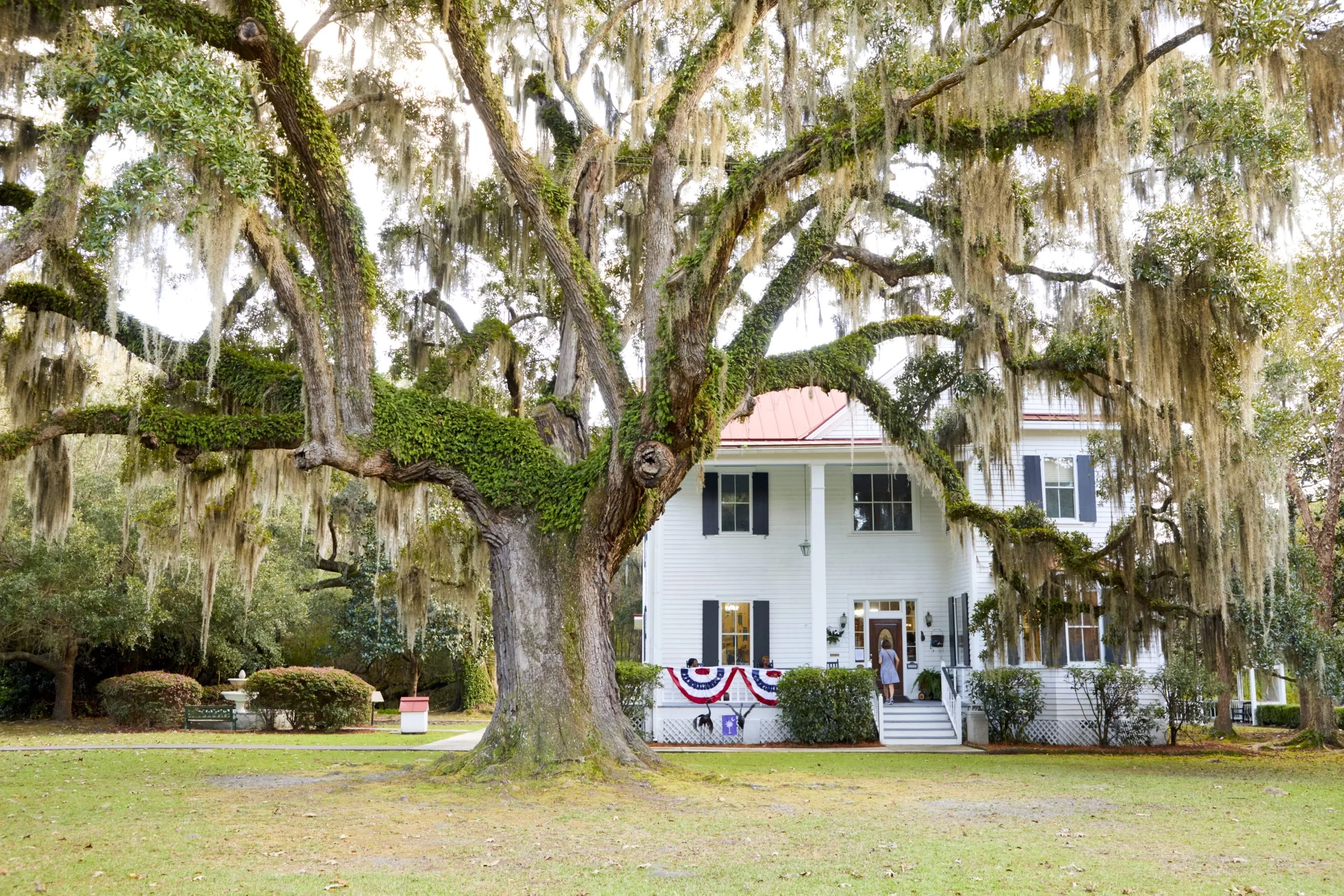
Although the first three objectives were met, the Union troops did not make it to the railroad on this particular day. Reconnaissance of the Broad River and its tributaries was completed, boat landings were effected on those tributaries and intelligence was gathered on the strength of the enemy on the mainland. The Union Army could not make it to the railroad to destroy the tracks. The area of Pocotaligo would fall to Union control on January 15, 1865. The 17th Corps with General Sherman and the black infantry regiment of the 54th Massachusetts advanced across the Lowcountry. Frampton Plantation houses would also be burned at this time. Not much evidence can be seen today that reminds us of what happened in our backyard, so long ago. There is one tell-tale sign that is still visible. The “Frampton Line” earthworks were raised on this site by General Robert E. Lee’s troops in 1962. This 100-yard fortification was a fall-back position from which to defend the Charleston to Savannah Railroad. While not as visible today as it once was, it is labeled on the “Map of the Rebel Lines of the Pocotaligo, Combahee and Asheepoo” used during the Civil War. It can be seen just behind the Frampton House that was rebuilt in 1886. Google Maps show the earthworks as it extends deep into the woods.

Sources:
The Pocotaligo Expedition, Robert McNair, 1997
The Battle of Pocotaligo, South Carolina, Lewis G. Schmidt, 1993


