Forrest Gump may have been filmed over 26 years ago (in and around Beaufort), but the movie has not diminished in popularity. We often get visitors into the welcome center at Frampton Plantation House that are eager to see the local movie locations. The movie was set in Greenbow, Alabama, but was actually filmed, for the most part, in the SC Lowcountry and Savannah. Several locations are not too far from our visitors center at I-95, Exit 33 and Hwy 17. MAP TO LOCATIONS.
During the movie, Forrest is compelled to go to the Four Square Gospel Church to pray for shrimp. These scenes were filmed in the tiny area of McPhersonville, at Stoney Creek Independent Presbyterian Chapel (155 McPhersonville Rd.) This church was built in 1833 and is listed on the National Register of Historic Places.
Comparison image from Houses Then and Now website.Stoney Creek close-up image by Carmen Pinckney.Comparison image from Houses Now and Again website.Image by Carmen Pinckney.
From Frampton Plantation, turn right onto Hwy. 17 and proceed north for 1.4 miles. Turn left onto Hwy 21/ 17-A towards Walterboro. Travel 5 miles, then slow down when you see the Harold’s Country Club sign. Turn left just before this locally famous restaurant onto Pocotaligo Rd. Continue 4.2 miles until you see Sheldon Chapel on the right. (This isn’t the church from the movie, but it is also historically significant.) Turn just before it and proceed slightly farther. The road ends at the church.
Both Varnville comparison images by Houses Then and Now website.
To visit the town where Forrest grew up, head to Varnville, SC. Return to Pocotaligo Rd. and turn left. Travel 11.2 miles miles, then turn right onto Main St. When the road ends, turn right onto Hwy. 278/Gray’s Hwy. Continue for 4.1 miles. The road merges with SC 68. Continue to the left. Once you enter Varnville, turn right onto Main St.
Bluff Plantation comparison images by Houses Now and Then website.
The Gump House is no longer standing. It was built specifically for the movie. Since it was hastily built (not to code) it was dismantled after production. The entrance is still visible. It is on the 8,000-acre Bluff Plantation property. It only took two months to build the house, and only a handful of rooms were finished for filming. Turn left from Main St. and travel down SC Hwy. 68 for 15.1 miles. Take a slight right onto Connely St. in Yemassee for .2 miles. Turn left onto Hwy 17-A and follow it for 3.6 miles. Next turn right onto Combahee Rd. The entrance will be 5.3 miles further at 3547 Combahee Rd. This property is privately owned, so please be respectful. Jenny’s house was also built on this property but was destroyed for the film.
Photograph by Keelie Robinson
The setting for Greenbow’s elementary school is the former Walterboro Academy. It now serves as the Colleton Civic Center. (506 East Washington Street, Walterboro.) This was the setting for the principal’s explanation of Forrest’s intelligence testing scores. From Bluff Plantation, return 5.3 miles to Hwy 17-A and turn right. Travel toward Walterboro for 11.5 miles. Take a slight right onto S. Jeffries Blvd. In 1.8 miles turn right onto Hampton St. The destination will be .4 miles away on the right.
Image from Houses Then and Now website.Image by Glenn Hanna.
After you leave this scene, head to Beaufort via Hwy 21/Carteret St. The Woods Memorial Bridge connects Beaufort to Lady’s Island. This is the scene for the running bridge interview. This is not the mighty Mississippi, but the Beaufort River. This historic swing bridge connects Beaufort to the sea islands. It is one of a handful of swing bridges that still exist in the state. It’s also the home of the annual “Run, Forrest Run 5K”.
Image by Houses Then and Now.Image by Corey Gibson.
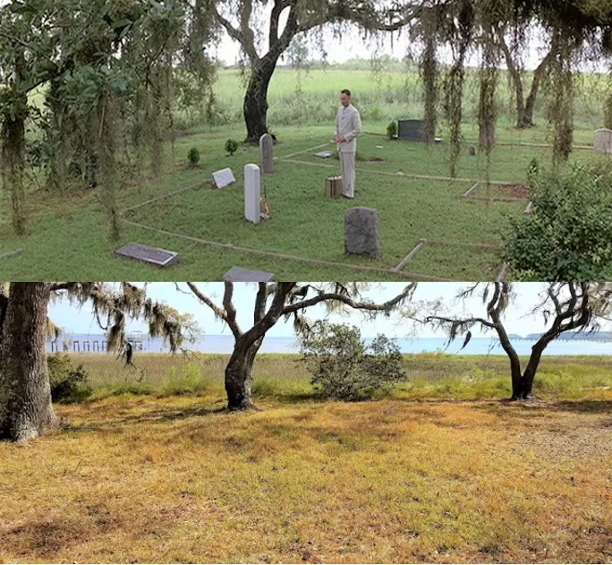
The house where Bubba lived is next on the tour. Continue across the bridge and just over a mile. Turn left at the light onto Sam’s Point Rd. Keep going through the traffic circle (take the second exit). Stay on Sam’s Point Rd. for six miles. Turn left onto Alston Rd. 145 Alston Rd. will be on the right. This 1,240 square foot house was built in 1940. Bubba’s grave site was constructed in the back yard. This is a private residence. Please be respectful. The water adjacent to the house is the Lucy Point Creek. That’s where the majority of the shrimp boat scenes.
Comparison image by Now and Again website.Comparison image by Now and Again website.
Bubba’s momma was played by Dr. Marlena Smalls. This classically trained soprano founded Beaufort’s Gullah Festival and the Hallelujah Singers. Her singers were also featured in the movie. She is well-known for using music and stories to educate others about Lowcountry Gullah customs and beliefs.
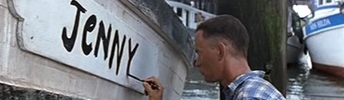
To visit the Vietnam war scenes, return down Sam’s Point Rd. and back to Hwy 21. Turn left onto Hwy 21/Sea Island Pkwy. As you drive toward Hunting and Fripp Islands, notice the march and waterways. They should look familiar. You will also pass Gay Fish Company on the right. They supplied all the shrimp for the movie.
Image courtesy of SC Lowcountry Tourism Commission.
Their dock is also where Forrest paints ”Jenny” on his boat. The Gay Seafood boat “Miss Hilda” can be seen in the background of that scene. Docked shrimp boats paint a beautiful scene. Travel for 16.8 miles. You will drive past the entrance to Hunting Island State Park.
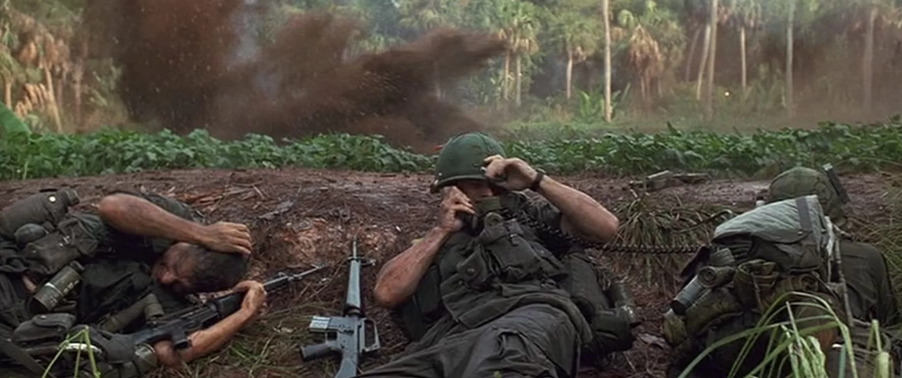
The boardwalk will be on the right. Park and walk along the boardwalk while you’re here. The war rescue scene that earns Forrest a medal happened inside the park at the lagoon.
The Ocean Creek Golf Course at Fripp Island was also the location for war scenes. The mountains and larger palm trees were added by special effects.
Francis Jones taught African American children on Daufuskie Island for 39 years. She lived in this house on the island.
Daufuskie Island has a very rich Gullah history. “Gullah” refers to descendants of Africans who were enslaved on the rice, indigo and Sea Island cotton plantations of the lower Atlantic coast. After emancipation and the Civil War, the Gullah of Daufuskie Island were able to live an isolated life creating a unique culture with deep African retentions. They have distinct arts, crafts, food, music and language. According to the GullahGeecheeCorridor.org “The Gullah language is the only distinctly, African creole language in the United States and it has influenced traditional Southern vocabulary and speech patterns.”
This 1939 image shows Gullah men working on an oyster bed. The 1937 image of Jane Hamilton School shows how it looked before restoration. Today it is the home of the Gullah Learning Center. Images found on NOAA Fisheries and national Register websites.
After the Civil War plantation owners abandoned Daufuskie Island. Former slaves that returned to the island bought parcels of land and built cottages. They worked in farming, logging and oyster canning. By the mid-1900s, these industries dried up and work had to be sought off the island. Many of their homes fell into disrepair. Through a grant from Palmetto Trust for Historic Preservation’s “Daufuskie Island Endangered Places Program”, many of these homes and other structures have been restored. A tour on the island is like walking back in time.
To experience the Gullah history of Daufuskie Island, follow the Robert Kennedy Trail. The trail maps out 20 historic landmarks that depict the Daufuskie Gullah way of life that has been present for so many generations. Download the map or pick up a copy at the Billie Burn Museum, then set out and see history come to life.
The Billie Burns Museum is located in the former Mt. Carmel Baptist Church No. 2. Photos by Troy Farren.
The first stop is the Billie Burns Museum. Housed in the former Mt. Carmel Baptist Church No. 2, the museum contains artifacts illustrating periods of island history. This is the second church built on the site by the Cooper River residents. The first was destroyed by hurricane. The current structure was built in the 1940s. The church was abandoned when island population declined. It was restored in 2001 and repurposed as the island’s museum.
Jane Hamilton School has been restored and now serves as the Gullah Learning Center. Photos by Troy Farren.
The Jane Hamilton School Gullah Learning Center is just next door. Cooper River children attended school at the first Mt. Carmel Baptist Church No. 1 until the hurricane destroyed it in 1940. The one-room Jane Hamilton School was built and used for ten years. When the students outgrew the school, they were transported to the southern end of the island to attend the two-room Mary Fields School. The building was restored in 2008 and now holds the Gullah Learning Center and community library.
Tabby ruins can be seen on the island and across the Lowcountry.
2. Tabby ruins can be seen at the second stop of the tour. Oyster shells were ground, mixed with sand and water and used to construct the foundations of Haig Point Plantation. This very durable building material predated concrete and can be found throughout the Lowcountry.
Cooper River Cemetery images by Dawna Larsson.
3. The Cooper River Cemetery is a very important stop when learning about Daufuskie history. Gullah tradition places cemeteries near moving water so souls could travel home to Africa. Situated beside the Cooper River, the cemetery has grave markers dating back to 1917, but the hallowed grounds have been in use for burials since plantation days.
Haig Point Lighthouse photo by Dawna Moore. Golf course photo found on Golf Advisor.
4. Haig Point is a developed community today. Access is for owners and guests only. The Haig Point lighthouse can be seen from Calibogue Sound at the northern tip of the island. This lighthouse was built in 1873 and remained operational until 1924.
Melrose tabby ruins and Island Club images from melrosepoa.com.
5. Melrose was once a large self-sustaining plantation. After Union occupation of the island, the Gullah people either worked for the landowners or bought land of their own. They lived in former slave cabins or built cottages on their own land. Several examples of these cottages a have been restored and still stand strong today.
6. From the late 1800s to the 1950s, the primary economy of the island was oyster harvesting and shucking. The Oyster Union Society Hall was established in this 1893 building. The union society was a benevolent and burial society that held meetings and social events. Members joined by way of an initiation ceremony. Pollution from the Savannah River ruined the oyster beds and the oyster industry on Daufuskie came to a close. The society dissolved after the oyster beds were closed. The building still stands as a reminder of a bygone way of life.
The Hinson White House is available for short term rentals through Airbnb.
7. The next stop on the tour is the Hinson White House. This 1926 house represents Daufuskie Island Gullah architecture. Large screened porches provide cooling shade in the hot summer months. The house was restored by the Palmetto Trust for Historic Preservation in 2015. While the residence is private, it is listed on Airbnb for short-term rentals.
8. The Mary Field Cemetery is the largest Gullah cemetery on the island. The earliest wooden tombstones have disintegrated from age. The earliest date visible in the cemetery is 1926. The cemetery is still in use today.
The Sarah Grant House is also available for short term rentals.
9. Sarah Grant bought her home in 1910 for $15 and had it moved to its present location for an additional $25. She was a midwife, Sunday school president and PTA president. She was married to the island undertaker. When he died in 1962, she stepped in and took his place, making her the one who saw islanders come into the world and go out! This is a private residence, but is available for short-term rentals on Airbnb.
The oyster industry was a major source of income across the coastal south.
10. A Beaufort County public dock is located at the end of Haig Point Road. This is the former location of the Maggioni & Company Oyster Cannery. This facility opened in 1883, employing many of the islanders. The cannery closed in 1903, but the locals continued to harvest and shuck oysters, transporting them to nearby canneries. This continued until the 1959 pollution of the Savannah River closed the oyster beds.
White School House images by the National Register and Dawna Moore.
11. White School House was built in 1913 for the white children of the island. It closed in 1962. The structure has since been used as fire department headquarters, island library and thrift store. It is now home of the Daufuskie Island Historical Foundation’s archives.
Council Tree image by Carol210. Perhaps a tree similar to the tree on the right is the sister tree?
12. Many islanders found themselves under live oaks after Sunday church service. Not wanting to discuss everyday problems on church grounds, men would move off church grounds and gather under the shade of a nearby live oak. Rumor has it, there was also a sister tree for the ladies.
First Union Baptist Church images by Airbnb and Sea Pines Real Estate.
13. First Union African Baptist Church was built in 1881 near the 1881 church that was previously destroyed by fire. This church has stood the test of time, serving the island since it was built. The church was restored in the 1990s. A replica of a traditional praise house is located behind the church.
Photos from Rami Michaels, the National Register and the University of South Carolina Archives.
14. Mary Field School was the biggest school on the island. This two-room facility was built in the early 1930s to educate the black children of the island. Leftover wood from construction was used to build student desks. Pat Conroy briefly taught school here. He was the first white and the first male to teach in the school. He used his experiences on the island as the backdrop for his book The Water is Wide, which was made into the motion picture Conrack. Miss Francis Jones was the first teacher when the school opened in 1933. Her house is next on the tour. The school was integrated in 1962 and continued to educate island children until 1997. Currently it houses the School House Coffee Shop and Daufuskie Blues Indigo Textile Studio.
The Francis Jones House before restoration image is by the Island Packet. The restoration image is by Dawna Moore.
15. The most iconic house on Daufuskie is the Francis Jones Home. This Gullah home was built in the late 1860s. Additions were made over the years. Francis Jones was a much-loved teacher of the African American children of the island from 1930 – 1969. At times she was the only teacher, working with as many as 96 children in two daily sessions. The Palmetto Trust for Historic Preservation restored the house in 2014. It is available for short term rentals through Daufuskie Island Accommodations.
Moses Fickling House images by Dawna Moore and the Coastal South.
16. The Moses Fickling Cottage sits beneath an ancient live oak tree, which is covered in resurrection fern and dripping with Spanish moss. It is reported that this tree is so old it greeted the Spanish when they first came to the island in the 1500s. This classic Gullah cottage was built around 1925 for Mr. Fickling and his wife Grace. He was the island undertaker and a deacon at the First Union African Baptist Church. The old carriage that he used as a hearse has been restored and is on display outside the Billie Burn Museum. This beautifully preserved home is a private residence.
Mary Dunn Cemetery images found on Flickr.
17. The Mary Dunn Cemetery is not too far away on Prospect Road. This is the only historic cemetery for white residents of Daufuskie Island. It dates to the 1700s. The cemetery borders the Mongin Creek and was donated by Mary Dunn. It is privately owned and still in use today.
Bloody Point Golf Club and Resort images.
18. Bloody Point is at the southern tip of the island. It got the name during 1715 when three different bloody skirmishes with the Yemassee Indians caused the water to run red. Bloody Point is the southernmost inhabited point of South Carolina.
Bloody Point Cemetery lies beside the water at the southern end of the island. Images by Dawna Larsson.
19. The Bloody Point Cemetery is located near the beach. This Gullah cemetery was placed along the Mongin Creek and used for slave burials during the plantation era.
Bloody Point Lighthouse as seen in 1883 and today. Images found on the National Register and Daufuskie Island websites.
20. The Bloody Point Lighthouse and Silver Dew Winery are the last stops on the tour. This is not a typical lighthouse. In fact, it is similar to the lighthouse keeper’s cottage on Tybee Island. A large second-story dormer houses the light that guided ships into the Savannah River channel from 1883-1922. This well-preserved historic structure contains a collection of artifacts and documents telling the story of Daufuskie. There is also an interpretive garden on the grounds that includes cotton, rice and indigo.
Stop in at the Silver Dew Winery. Photos by daufuskiedifference.com and Dawna Moore.
Just out back of the lighthouse sits the Silver Dew Winery. This building was built as a “wick house” to store oil, wicks and other items needed to run the lighthouse. In the mid-1900s it was converted into a winery. Wine was made from grapes, scuppernongs, pears, elderberries, and other fruit grown on the island. Pat Conroy mentions the Silver Dew Winery in his 1972 book The Water is Wide.
If visiting Daufuskie Island is in your future, there’s only one way to get there – by boat. It’s just thirty minutes from Hilton Head Island, and an hour from Savannah. The Daufuskie Island Ferry https://www.daufuskieislandferry.com/directions/ has departures throughout the day. Reservations are a must. Once on the island, a golf cart or bike rental is a must for getting around. The island is five miles long and two miles wide. The ferry office can assist you. Reservations are strongly recommended.
Artwork near Yemassee’s Amtrack Station Honors Marine Recruit Depot History
The Folded Flag, by Sophie Docalavich, 2020.
A second installation of artwork has popped up near the Yemassee Amtrack Station. The mural, entitled “The Folded Flag” was positioned along the fence line that formerly bordered the Marine Recruit Depot barracks.
Where heroes Stood, by Sophie Dacalavich was installed in 2019.
The artwork compliments work that was installed in 2019. Artist Sophie Docalavich of Estill, SC was commissioned to paint both murals to honor the many marine recruits that made a brief stop in Yemassee before heading to Parris Island for basic training.
Photo by Peter McCusket., 1959.1918 image from Parris Island website.
More than 500,000 marine recruits rode the Atlantic Coast Line Railroad to Yemassee’s Marine Recruit Depot between 1915 and 1965. These recruits began their military career in the Yemassee barracks before heading to Parris Island for basic training. During this time, Yemassee had a bank, general store, and hotel complete with ballroom.
Photo by Peter McCusket, 1959.Yemassee train station in the 1950s and today.
Depending on the time of day, new marine recruits would either be processed and sent directly to Parris Island or spend their first night in the Yemassee barracks. When ready, recruits boarded the Charleston & Western Railroad and made the next leg of their journey to Port Royal. Prior to 1928, recruits would be loaded onto ferry boats, barges, long boats, or small motorboats to cross the river onto Parris Island.
The former marine barracks was moved across the street and repurposed as a store.
With all the activity in Yemassee, the town saw the construction of a soda fountain and several brick buildings in 1926. The town continued to grow and by 1932, Yemassee had over 30 buildings including a Greyhound Bus Station.
Life Magazine’s 1942 article on Yemassee, SC.
During World War II Yemassee continued to grow with the addition of barracks to house incoming recruits. 250,000 recruits (including women) began WWII marine training in Yemassee. The town became so popular that Life Magazine visited in 1942. Photographer Alfred Eisenstaedt created a photographic essay of the town entitled, “Life Spends a Day at Yemassee Junction”. Seven pages of photographs were published. He described Yemassee as “a railroad junction not too big to be confusing, not too small to be trivial.” The marine depot was still active during the Korean War, when as many as 350 new recruits would arrive daily.
Photo from Town of Yemassee.
In 1965 the Marine Corps terminated their lease with the Atlantic Coast Railroad Company. The receiving facility and barracks were returned to the railroad company as well. Recruits were then flown into Charleston and bused to Parris Island. This change ended the 50-year association with the railroad and the town of Yemassee.
Yemassee Marine Recruit Depot as it looked in its early days. Photo from Town of Yemassee.
A later renovation changed the roofline. 2011 photo by Big Daddy Dave.
Recent renovations transformed the station to its former glory.
After falling into disrepair, the historic Yemassee train station has been beautifully restored by the Yemassee Revitalization Corporation. The town purchased the train station in 2010 from CSX for $1 and launched a restoration campaign. While restoring the building, the team also raised funds to expand a brick memorial and garden on the site of the former marine barracks. Flags fly high over the site paying homage to the marine corps and the country.
Follow the Revolutionary War path of Dr. Uzal Johnson as he traveled the Lowcountry.
The Lowcountry Revolutionary Trail winds through Beaufort, Colleton, Hampton and Jasper Counties. It follows the path of Dr. Uzal Johnson of the New Jersey Volunteers during the Revolutionary War.
Dr. Johnson, a loyal American volunteer spent time in the Lowcountry during the spring of 1780. He witnessed skirmishes at Ft. Balfour, Saltketcher’s Bridge, McPherson’s Plantation, and the Battle of Coosawhatchie. You can retrace his footsteps and see what remains of the sites.
Start your Lowcountry Revolutionary War journey at Frampton Plantation House gazebo. Located behind the house, the gazebo contains a map of the sites and information about the trail. Come inside the visitors center if you have any questions, or need directions. We will be happy to help you with this journey. Frampton Plantation House is located behind the Marathon Gas Station in Point South 698 Kings Highway (Hwy. 17), 843-717-3090.
The first stop is the location of the Battle of Coosawhatchie (Hwy 17 at the Coosawhatchie River bridge). On May 3, 1774 Lt. Col. John Laurens and 250 men were in position on a slight rise near the bridge at Coosawhatchie. They were guarding the road against the expected assault by about 2,400 British soldiers from Savannah. Against orders, Laurens and his men crossed the river and formed a line for battle. With many of the soldiers and Laurens himself wounded, they fell back to the Tullifinny River, about two miles east.
2. Look for the Lowcountry Revolutionary War Trail marker on the eastern side of Highway 17 near the Coosawhatchie River bridge, and in front of the Second African Baptist Church, 6904 W. Frontage Rd.(Hwy 17). The sign bears an excerpt from Dr. Johnson’s journal stating, “Despite the defeat at Port Royal Island, General Prevost was determined to make a second attempt to capture Charleston. Instead of a small detachment of 150 men, this time he crossed the Savannah River with 2,400 British regulars, and once again, William Moultrie stood in his way. This time, however, Moultrie was outnumbered 2 to 1. He determined to make a stand on a slight ridge at the Tullifiny River, about 2 miles east of the Coosawhatchie River, where he left about 200 men to guard the crossing and warn him of the Redcoats arrival. As the enemy drew near, Moultrie was about to send as aide to pull these troops back to the main force when Col. John Laurens offered to lead them back. Moultrie had so much confidence in the officer that he sent along 250 men to help cover the flanks. In direct disobedience of orders Laurens crossed the river and formed the men in line for battle. He failed to take the high ground and his men suffered greatly from well placed enemy fire. Laurens himself was wounded, and his second in command fell back to the main force at the Tullifinny, where Moultrie was compelled to retreat towards Charleston.” Excerpt from South Carolina’s Revolutionary War Battlefields A Tour Guide.
3. From here, Dr. Johnson headed to the home of Isaac McPherson, who was described by the doctor as “a great (Revolutionary) Rebel, a man of property. British soldiers occupied the McPherson Plantation March 14-17 while trying to track down 50 Americans on horseback. During the occupation, the British engaged in what they thought was a skirmish with the Americans. They were mistaken and attacked their own troops instead.
The historical marker is located beside the Sheldon Chapel, 25481 Pocotaligo Rd. in McPhersonville. It reads, “Tuesday 14th March 1780 – At four o’clock in the afternoon, Col. Ferguson and part of the American Volunteers and twenty men in the British Legion proceeded nine miles to McPherson’s Plantation. We got to Isaac McPherson’s at nine o’clock. Fifty Rebels on horseback had just left this and gone to John McPherson’s. A party of ours pursued them but could not overtake them.
Wednesday 15th March 1780 – Still at McPherson’s Plantation foraging parties get everything that is needed for the Army.
Thursday 16th March 1780 – Lay at McPherson’s living off the fat of the land, the soldiers every side of us roasting turkeys, geese, fowl, ducks, pigs, and everything in great plenty. This McPherson is a great Rebel, a man of property and at present is in Charles Town.” Excerpt from the Diary of Dr. Uzal Johnson, Surgeon.
4. The British left McPherson’s Plantation on March 18, 1780 and marched to the crossing of the Saltketcher (now the Salkehatchie) River, where a bridge had stood before the beginning of the war. They were met by 80 American militiamen who tried to prevent their crossing. The British Light Infantry crossed the river below this spot and came up behind the Americans. A captain and 16 privates were bayoneted to death by the British, who then spent the night at nearby Ogilvy’s Plantation.
The historic sign is located at the boat ramp on Hwy 17-A on the Salkehatchie River, just outside Yemassee. It states, “Saturday 18th March 1780 – Got in motion eight o’clock in the morning and marched ten miles to the Saltketcher. Major Lordson with eighty militiamen placed themselves on the north side of the river to oppose our crossing. They were opposed by the British Legion returning their fire at a place where the bridge formerly stood, while the light Infantry and remainder of the Legion crossed the river below and came in their rear before they knew of it. Here the bayonet was introduced. A Capt. Mills and sixteen privates of the (Revolutionary) Rebels were killed, four badly wounded and one made prisoner that luckily escaped the bayonet.
Sunday 19th March 1780 – Passed Saltketcher River that place where the bridge stood.” Excerpt from the Diary of Uzal Johnson, Surgeon.
5. In the fall of 1780, the British built an earth and palisade fort to maintain control of Beaufort and protect the King’s Highway (Hwy 17) between Savannah and Charleston. Ft. Balfour was built at the key crossroad at Pocotaligo and named for the British commander of occupied Charleston. In April of 1781 Col. William Harden was detached from Gen. Francis Marion’s Brigade with 100 men. On April 14 Harden convinced old friends from Beaufort who were in command of Ft. Balfour that he had more troops than he did and that they should surrender. They believed him and did. Learning that British soldiers were on the way from Charleston, Harden and his men burned the garrison.
No one is quite sure of the fort’s exact location today, but the marker is places alongside the marsh of the Pocotaligo River at 2 Trask Parkway (Hwy. 17), beside the Family Worship Center Church. It reads, “In order to maintain control of the Beaufort District and protect communications on the King’s Highway, an earth and palisade fort was built on the high ground between Coosawhatchie and Pocotaligo bridges: the strategic crossroads of the Southern Parishes. This fort was named for the commander of the British garrison at Charleston during the fall of 1780, Lt. Col. Nisbet Balfour, one of the most disliked officers in South Carolina.” Excerpt from the Diary of Uzal Johnson, Surgeon.
Locating these historic spots and reading the journal entries of Dr. Johnson gives visitors the chance to reflect on how intensely our forefathers fought for the freedoms that we enjoy today. Let your gaze wander the landscape where these brave men engaged in battle and fought valiantly to protect us.
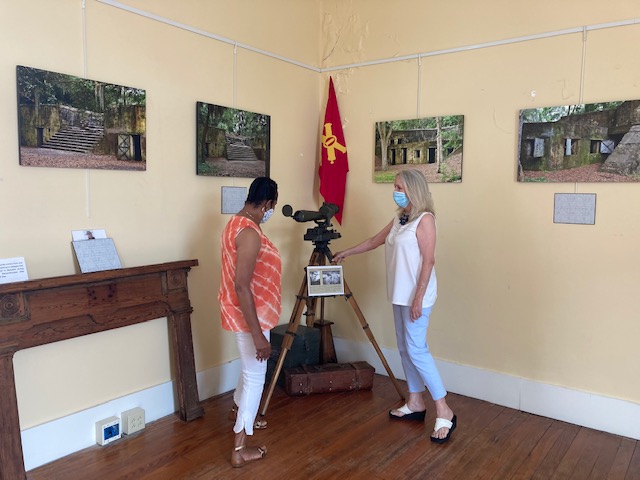
Visitors to Beaufort History Museum are invited to explore the history of Fort Fremont, a fortification built by the U.S. Army Corps of Engineers on Saint Helena Island in 1898, by viewing a special exhibit that displays award-winning images and a modern instructional video featuring exclusive drone photography of the site.
The Exhibit was officially introduced to Beaufort History Museum Board Members and Friends of Fort Freemont at an open house on July 15. The images featured are loaned to the Museum by noted Savannah photographer Mike Tillison. BHM Board Member Jeff Kidd created the video, a preview of which may be accessed at: https://www.facebook.com/Beaufort.History.Museum/videos/393167394933323/
Fort Fremont was constructed in response to the Spanish American War to defend the coaling station and dry dock at the Port Royal Naval Station located on Parris Island. It was one of six fortifications designated to protect the southeast coast during the war. It honors Major General John C. Fremont who was a Republican Presidential Candidate and Union Civil War General. The Fort was officially deactivated in 1912.
Beaufort History Museum has evolved to focus specifically on the history of the Beaufort District. It strives to manage and display artifacts and documents held by the City of Beaufort, telling the compelling stories of this area from the early 16th Century until modern times. Docent classes are conducted on an ongoing basis.
The Arsenal address is 713 Craven Street. Normal BHM hours of operation are 10:00 AM – 4:00 PM, Tuesday – Saturday. Docents are on duty to provide information and conduct tours. Please visit www.beauforthistorymuseum.com or the BHM Facebook page for updates and news from the Museum.
For information on becoming a Docent or Volunteer Greeter contact the Museum at info@beauforthistorymuseum.com or call 843-379-3079.
The Anchorage was built around 1770 by Ralph Emms Elliott. Upon his death, the house passed to William Elliott. The tabby construction house is thought by many to be the most elegant house on the bay. William Elliot was a politician, planter, sportsman and author. He entertained the Marquis de Lafayette at this home in 1825.
Photo from the South Caroliniana Library archives.
The house has seen many transformations over the last 250 years. It was designated Union Hospital No. 11 during the Civil War and called the mission house. Next, it saw life as a Club House for the Sea Island Hotel. General Wade Hampton gave a speech from the piazza while running for governor. By 1891 the house was repurposed as the Ribaut Social Club, complete with bar and roulette wheel.
Photo from the 1940s collection of Mrs. John F. Maag.
In March of 1891, the home was purchased by a Naval officer, Rear Admiral Lester Beardslee for $4,000. He quickly began returning the building to its former glory. The April 3, 1902 issue of the Beaufort Gazette reported, “The renovation of the old tabby Clubhouse on the opposite corner from the Sea Island Hotel…for a handsome mansion is progressing, and soon it will be made an imposing residence. Only a shell of the old building is being preserved, and entire new house walls are being built inside. The mansion will be the finest and most elegant in town.”
Photo by Amy Lesesne.
The tabby exterior was preserved by covering it in stucco during a 1902 renovation. During the same time an elevator was added along with the third level porch. Several secret compartments were also added to hide liquor from the owner’s wife. Upon completion of the $80,000 renovation, the Admiral christened the home “the Anchorage”.
Photo by Amy Lesesne.
Between 1931 & 1966, the Anchorage was used as a tourist home. Hurricane Gracie blew into Beaufort in 1959, causing extensive damage. In 1969 the house was converted into the Anchorage House Restaurant. Sadly, by 1971 the building was facing demolition. The Historic Beaufort Foundation stepped in and saved it from devastation. It was bought, restored, and turned into an elegant and distinguished restaurant. The Anchorage even spent a brief period as corporate offices in 1999. Then in 2007, it became a restaurant again.
Photo by Amy Lesesne.
New life was breathed back into the Anchorage in 2014, when Amy and Frank Lesesne purchased the property. They worked diligently to maintain, preserve, and enhance the property while reopening it as an inn.
Photo by Amy Lesesne.
Visitors can choose from waterfront, water view or garden view rooms. Guests looking for a romantic getaway can book a suite in the cottage. Relax by the fire, or sip wine on the balcony or patio. Every room at the Anchorage 1770 offers a unique experience. Tastefully decorated rooms have four-poster beds, high ceilings and detailed plasterwork from the 1880s.
Certain rooms at the Anchorage are also dog friendly. Just let the staff know you plan to bring your furry friend, and you will be booked accordingly.
Photo by Amy Lesesne.
Conde Nast Traveler wrote, “Owners Amy and Frank Lesesne were careful to update its 15 rooms without shedding centuries of history: the boutique inn was once a private home, a Union Army hospital and a clubhouse for the literary elite.”
Photo by Amy Lesesne.
Looking to pamper yourself? After breakfast in bed, indulge in yoga classes on the verandah as well as a spa or beauty treatment in the privacy of your room.
Photo by Amy Lesesne.
After a day exploring Beaufort, come back to the Anchorage 1770 to dine at the Ribaut Social Club. Enjoy cocktails on the porch followed by regional cuisine in the dining room. Reservations are strongly recommended. Sunday brunch is also available.
Photo by Amy Lesesne.
According to Coastal Living Magazine, the Anchorage is “Elegantly perched overlooking Beaufort’s Harbor River, Anchorage 1770 is housed in the so-called “Queen of the Bay,” a Federalist manor that has served myriad purposes over its almost 250-year history… everyone can gather on Anchorage 1770’s upstairs porches for small plates and drinks in the evenings. Happy hour has never been happier.”
The historic churches of downtown Beaufort are steeped in cultural history and refinement. Each structure tells its own story in the life of this important city. Situated between Savannah and Charleston, this beautiful city by the sea retains much of its antebellum charm. The churches were used as stables during the Revolutionary War and hospitals during the Civil War. Others were used as schools for Freemen before, during, and after Reconstruction. Spending a day visiting these Beaufort landmarks is soothing to the soul.
The Parish Church of St Helena – 505 Church Street
The steeple of the Parish Church of St. Helena can be seen above the treetops in downtown Beaufort. The church is surrounded by a brick wall that dates back as far as the church.
The Parish Church of St. Helena was founded in 1712, and built in 1724. It was rebuilt in 1769 and extended to the west in 1817. All but the westward extension was demolished in 1842 and new wings were added which would accommodate a larger congregation. The church was used by the British to stable horses during the Revolutionary War.
Tabby construction was used in the construction of the wall surrounding the cemetery.
Union troops repurposed the church as a hospital during the Civil War uprooting headstone slabs to serve as operating tables. Union sailors stationed in Beaufort donated an alter for the church sanctuary after the war.
The church is surrounded by a historic cemetery that predates the Revolutionary War.
The church graveyard is full of interesting and well-known Beaufortonians, including Colonel John Barnwell. He was famously known as “Tuscarora Jack”. Colonel Barnwell gained fame when he made an alliance with the Yemassee Indians and defeated the Tuscarora Indians of North Carolina, then forged a peace treaty. He died in 1724 and because of expansion, is buried under the church.
A close-up shows attention to detail used by the craftsmen that built the surrounding brick wall.
Two British officers killed during the Revolutionary War are buried in the graveyard. American Patriot Captain John Barnwell sent a soldier into the church to retrieve a prayer book, then performed a burial service for the British soldiers. He then said that America could defeat the British while still having the civility to give them a Christian burial.
Flags mark the historic graves of servicemen that are buried in the churchyard.
Confederate Generals Lt. General Richard H. Anderson and Brigadier General Stephen Elliott are buried here as well. The cemetery across the street contains the graves of persons who died from dueling and suicide since they were not allowed burial on the hallowed grounds of the church yard.
Wesley United Methodist Church – 701 West Street
Wesley United Methodist Church is surrounded by native palm trees. Photo by Cosmos Mariner.
The Wesley United Methodist Church was established in 1833 as a mission for slaves and free blacks of Beaufort and the surrounding sea islands. This church, whose congregation was made up of black and white members was built in the meeting house form, which was common to the Methodist church.
The beauty of this historic church lies in its simplicity. Photo by Cosmos Mariner.
The churchyard contains unmarked graves that predate the sanctuary’s construction. Headstones of both black and white members can be found in the cemetery. The church’s third pastor was buried here in 1871. According to legend and the blog of Fallon Green, an African American Genealogy expert, “These hallowed grounds contain the remains of former slaves, civil war soldiers, and some of Beaufort’s earliest prominent citizens.
Large, clear windows provide light into the sanctuary.
The church building was given a new role in the community during and after the Civil War. The church hosted a school for freemen. It also continued to serve the community as a house of worship. The church was turned over to the African American congregation after the war and began a formal affiliation with the Methodist Episcopal Church. During Reconstruction, the first black minister was appointed to the church in 1873.
As with all historic churches in Beaufort, a historical marker tells the story of the church.
It is believed that the church was built in the 1840s. The outside structure has been dutifully maintained. The porch, steeple and choir loft were added sometime between 1849-1899. From 1847-1850, the church had 379 African American and 27 white members. The church proudly stands today in pristine condition and serves as a monument to the history of the African American population of Beaufort.
The Wesley United Methodist Church has an active congregation.
A commemorative plaque recognizes the foundation they laid for others to build upon and is dedicated to all – known and unknown – who rest here in.
The Baptist Church of Beaufort – 601 Charles Street
Beaufort Baptist Church is a stately presence on Charles Street.
The Baptist Church of Beaufort began life on this spot in 1795. The present building was built in 1844 at a cost of $10,000. In 1857 the congregation was comprised of 183 white members and 3,557 slave members (many of the slave members attended missions on the sea islands). After the Civil War, the formerly enslaved members went on to create Tabernacle Baptist Church and the First African Baptist Church.
This picture shows the church before the steeple was added. Image from Baptist Church of Beaufort Facebook page.
The church served as a hospital for black soldiers during the Union occupation of Beaufort. As a result, graffiti can still be found on the belfry beams and a sanctuary wall. A black deacon returned the communion silver that he had hidden away in his feather mattress during the war. The old pews were returned to the sanctuary. The communion table was recovered from Charleston.
The church’s communion set and table were returned to their rightful place after the Civil War. Photo from Baptist Church of Beaufort Facebook.
The congregation was able to reclaim and repair the Greek revival style house of worship after the war. Thankfully, the interior of the building was left intact. The cove ceiling is adorned with beautifully crafted plaster ornamentation. All plaster work was created by highly skilled slave artisans. The ceiling was restored in 1953. Craftsmen were able to use 98% of the original rosettes. Recently, the ceiling was once again restored.
The plaster ceiling is a memorial to the slave born artisans who created it. Photo from Baptist Church of Beaufort Facebook.
Doric columns support a gallery that wraps around three sides of the interior. This area has the best advantage for viewing the beauty of the interior and ceiling fretwork. The floors are made of heart of pine lumber and have been magnificently preserved.
The steeple has stood proudly above the church since 1961. Photo from Baptist Church of Beaufort Facebook.
A steeple was added to the church in 1961. Additions were also made to the rear of the church in 1997. 29 feet were added to the west wall to expand the sanctuary. This allowed for the placement of a historic pipe organ.
Tabernacle Baptist Church – 907 Craven Street
The carpenter Gothic facade of Tabernacle Baptist Church has beautiful arched windows that extend up to the steeple.
Tabernacle Baptist Church was built by Beaufort Baptist Church in the 1840s, to be used as a meeting house and lecture room. In 1863, Reverend Soloman Peck, of Boston, acquired the building, organized the church, and brought 500-members of the African American congregation from Beaufort Baptist Church to Tabernacle. In 1867 the congregation bought the property from Beaufort Baptist.
The stained glass windows are reminiscent of scrap quilts that were popular at the same time period. Photo by Robert Knight.
The church was rebuilt and rededicated after suffering damage during the hurricane of 1893. The stained-glass windows are fashioned from broken bits of colored glass that are held together by lead. To appreciate the beauty, it is best to see them from the inside.
If the church doors are locked, you can walk around to the church yard to view the windows. Pictures are displayed to show a glimpse of the wonder that lies within.
Windows facing the graveyard have examples placed on the windows to show visitors a view of what the windows look like from the interior. If you ever get the opportunity, walk inside, and stand in amazement at the beauty these windows create.
A monument to Robert Smalls sits to the right of the church near his grave.
The graveyard contains markers dating back to 1817, hinting that the praise house may have stood on the site before the 1840s. Robert Smalls and his first wife Hannah are also buried in the church yard. A memorial statue and plaque to Smalls is located beside the church.
Robert Smalls is a Beaufort statesman that served his city, state and country.
Smalls was born into slavery, then in 1862, while working as a part of the crew of the Confederate steamer “the Planter”, he captured the ship and sailed it out of the Charleston harbor past Ft. Sumter and right into the hands of the Union army. Smalls went on to serve in the Union army and captain “the Planter”. After the war, he had a distinguished career in the House of Representatives and Senate. He then served four terms in the U.S. House of Representatives.
St. Peter’s Catholic Church – 710 Carteret Street
St. Peter’s Catholic Church is surrounded by a brick wall that dates back to 1857.
The beautiful St. Peter’s Catholic Church is the oldest Catholic church in Beaufort County. Closed for many years, the church has been returned to its former glory. Built in 1846, the chapel intimately seats 100 parishioners. The classical revival church has beautifully restored double doors, flanked by large multi-paned windows. These large windows extend down both sides of the chapel.
A 1943 renovation enclosed the front porch. It was later restored to its original design. Photo from St. Peter’s archives.
A brick wall that separates the church from the street dates to 1857. A Gothic trefoil window was added over the pulpit in 1899. Be sure to meander through the churchyard where you’ll find several fine examples of 19th and 20th century gravestone art. The church served as a school run by abolitionists during the Civil War. The building continued service as a mission after the war. In 1923 the interior was renovated. The church doubled in size with additions in 1943. The nave was enlarged, and the front porch was enclosed.
A complete restoration was completed in 2012. Photo from St. Peter’s archives.
As time went on, the congregation outgrew the small chapel. Another church was built on nearby Lady’s Island. The small chapel then fell into disrepair until it was completely restored in 2012.
The serine sanctuary is a great venue for small weddings. Photo from St. Peter’s archives.
During the 2012 renovation windows were replaced with period-appropriate panes and restoration glass. Walls were replastered, hardwood floors were replaced, and the ceiling was repaired. An earlier renovation that enclosed the front porch was reversed and it was restored to its original design.
The front facade of St. Peter’s Catholic Church is adorned with wooden double doors that are flanked with large, shuttered windows.
Today the chapel is used for occasional weekday mass, small weddings, and funerals. Tours are also available at Historic St. Peter’s Catholic Church and Graveyard. Tours are canceled when special events are scheduled at the historic church. Call (843)522-9555 for more information.
First African Baptist Church – 601 New Street
Three sets of wooden doors welcome members of the First African Church of Beaufort.
The First African Baptist Church was built by freed slaves in 1885. The congregation grew from an Antebellum Praise House attended by some of the African American members of the Beaufort Baptist Church. These men purchased the land and built the praise house in 1863, only two years after emancipation.
The detailed carvings of the front doors were expertly designed and crafted.
The church was used as a school to educate freedmen after federal occupation. By 1865 a cornerstone was laid, and work began on the new church.
Windows that light the sanctuary are massive in height.
In 1885 the congregation had grown to more than 900 members. They built this handsome and commodious carpenter Gothic church. Its most prominent member was Robert Smalls. He was a Civil War hero, state legislator and US Congressman. Smalls is buried in the churchyard of nearby Tabernacle Baptist Church. Only two members of the church are buried on the grounds of the First African Baptist Church. Arthur Waddell served as first pastor to the church. He is buried here, along with Deacon Isaac Moultrie.
This sign commemorated the original praise house that stood on the site in 1863.
According to the historic plaque in front of the church, “In 1895 First African Baptist Church was described as one of the most aristocratic colored churches in Beaufort.” No attention to detail was spared on the construction of this beautiful church. The white clapboard siding, simple gothic windows with black shutters and wooden doors are kept in immaculate condition.
A ladder extends upward to gain access to the bell tower.
A peek through the second story middle window reveals a bell tower ladder. The front doorways are carved with circular motifs and crowned in pediments. The massive side windows boast 27 panes each! Almost the entire structure of the church as seen today is original. Today the former parsonage houses the church archives. Photos, historic documents, books, and bibles can be viewed here, along with an old travelling communion set.
First Presbyterian Church – 410 Church Street
The colonial revival church has tall, arched windows made of clear glass.
Beaufort’s First Presbyterian Church was built in 1928. Prior to construction, the closest Presbyterian church was Stoney Creek Chapel, located 15 miles away in McPhersonville. Stoney Creek Chapel was built in 1743 and served as a summer chapel when Beaufortonians moved inland to escape the summer heat and threat from mosquitoes.
A loft extends across one end of the sanctuary. The coffered ceiling and arched windows add to the beauty of the interior. Photo from First Presbyterian Facebook.
By 1912, the First Presbyterian Church of Beaufort was established, and sanctuary construction began in 1928. By 1929 a new white clapboard-framed church stood proudly on the corner of North and Church Streets. The colonial revival church has tall, arched windows made of clear glass. Church members worked diligently to complete the interior under the direction of chief carpenter and minister F.B. Mayes.
Live oaks, palm trees and azaleas fill the church yard.
By 1941 the church was completed, and all debt was paid. The Beaufort Gazette wrote an article about the church, stating, “This beautiful and artistic little church is a source of pride and gratification not only to the Presbyterians of Beaufort, but to the entire community.”
Arched shutters protect the buildings during storms.
When the 1950s rolled around the little church had grown to over 200 members. It was obvious that the time was right to expand. Rather than disturb the integrity of the beautiful church, a two-story building was constructed just across the street.
Azaleas bloom in the early spring. Photo found on First Presbyterian Facebook.
The church celebrated its 100th birthday back in 2012. The church has been preserved and retains its original integrity. The wooden floors and pews are just as beautiful today as when the church was first constructed. Black shutters adorn the arched windows on the sides of the church and azaleas in the churchyard bloom pink in the spring.
Beth Israel Synagogue – 401 Scott Street
The historic wooden synagogue on Scott Street is located beside the Beaufort Arsenal. Photo by Historical Marker Database.
Beaufort’s thriving Jewish community predates the American Revolution. The Beth Israel congregation originally held services in private homes, the Masonic Hall, and the Beaufort Arsenal. As membership grew the need arose to build a permanent home for the congregation. In 1905 members of the Jewish community purchased a lot on Scott Street adjacent to the Beaufort Arsenal. A charter was granted by the state on October 16, 1905. The building was dedicated on June 14, 1908 and the congregation has worshipped there ever since!
The side gate is adorned with an iron menorah.Photo by Historical Marker Database.
The Beth Israel Synagogue was built by members of the congregation. The simple, frame building is one of the few wooden synagogues in continued usage in the southeast. The white clapboard structure has wooden double entry that is flanked by narrow, tall, pained windows. The same windows line each side of the church building. A social hall was added in the 1950s.
Interior view by the Traveling Bornstein.
The congregation of Beth Israel Synagogue has been home to many prominent Beaufortonians. Alexander Hamilton’s half-brother Peter Lavien was a merchant who lived and worshipped in the city before the American Revolution. Major Meyer Jacobs of the Beaufort Artillery helped welcome the Marquis de Lafayette to Beaufort in 1825. Jacobs also served as mayor and a member of state legislature.
Beth Israel Synagogue history listed on a historical marker in front of the historic structure. Photo by Alice deForest.
Land for a cemetery was purchased in 1910. it sits nearby on Bladen Street. The cemetery has lovely iron gates that include the Star of David motif. A parsonage was also added for the religious leader in 1920.
The cemetery gates are decorated with the star of David. Photo found on Beth Israel Facebook page.
The Beth Israel Synagogue congregation celebrated its 1ooth anniversary in 2005. According to their website, “We work to maintain our religious traditions and Jewish identity, and to ensure at least another hundred years for this beloved Beaufort congregation, Beth Israel.”
Come spend an afternoon learning the history of Beautiful Beaufort by the Sea.
The Beaufort History Museum can be found in the historic Arsenal on Craven Street in the heart of the historic district. The Museum strives to manage and display the City of Beaufort’s collection of artifacts, documents and photos, which tell in a compelling manner the fascinating stories of the area.
Highlights are the arrival of the Native Americans, the first settlers; the European explorations of the early and mid-16th Century; the Revolutionary War; the rice, indigo and cotton Plantation Culture; the antebellum decades, secession and the Civil War; Reconstruction; the Spanish American War; and growth to present times.
Through community engagement, children’s programs, educational opportunities and social events the museum provides many services to visitors and local residents.
The Beaufort History Museum focuses specifically on the history of Beaufort. Artifacts and documents tell compelling stories of the area from the early 16th Century through modern times. You can find the museum at 713 Craven Street in historic downtown Beaufort. Hours are 10 a.m. to 4 p.m. Tuesday through Saturday. For questions call 843-379-3079.
Downtown Beaufort’s Henry C. Chambers Waterfront Park looks onto the Beaufort River. Photo by Peach Morrison.
Thinking about planning a trip to the South Carolina Lowcountry? Why not plan a relaxing vacation in an area that is known for its scenic beauty and historic architecture. The SC Lowcountry is the perfect spot to enjoy a vacation that includes quaint southern towns, beautiful beaches and wide open spaces.
Hunting Island image by Allyson Jones.
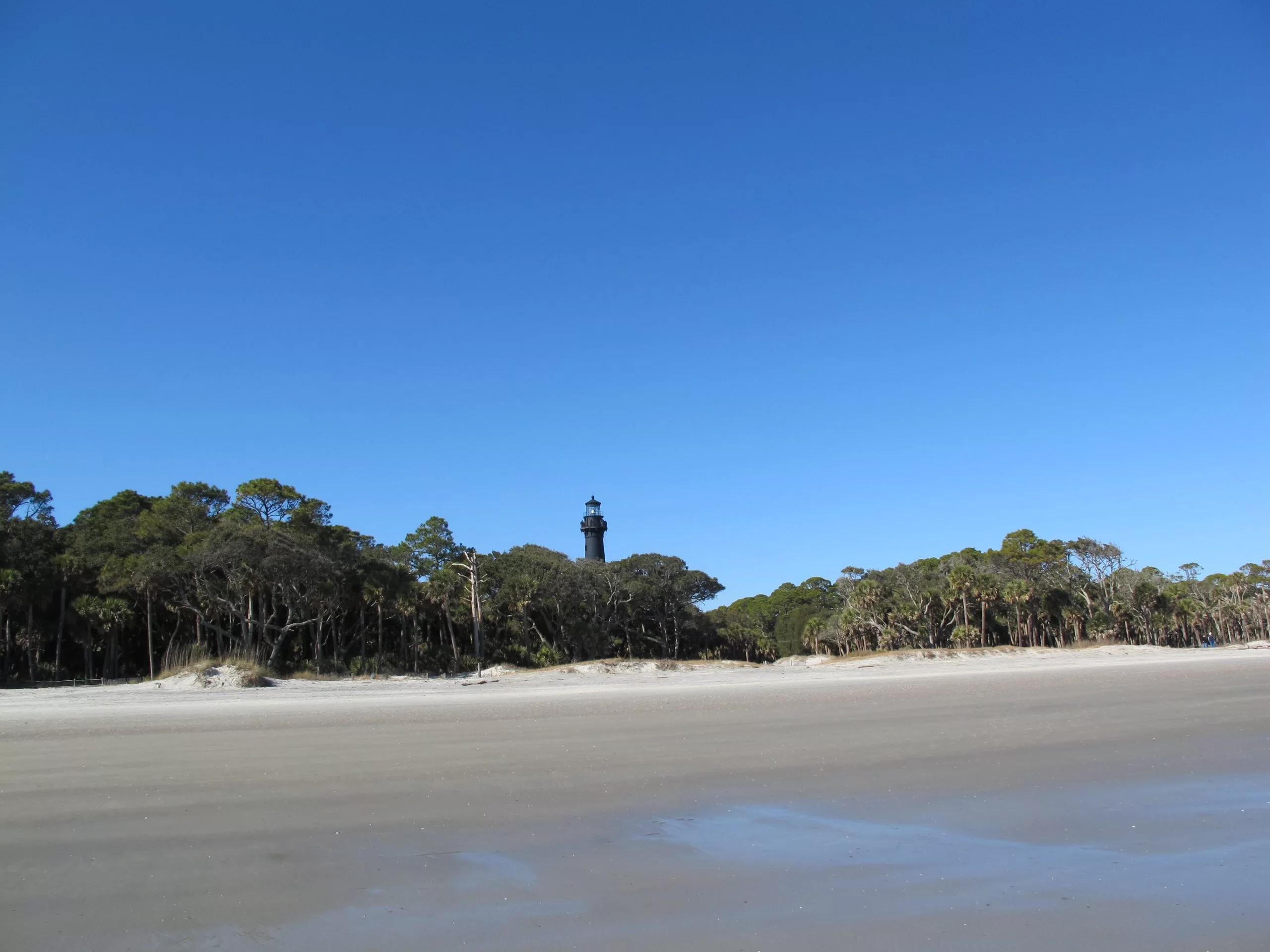
Hunting Island State Park is located 17 miles from downtown Beaufort. The park has 5,000 acres of beaches, hiking trails and plenty of fishing opportunities. Kayak, paddle board or hunt for crabs at the lagoon. Fish from the pier. Camp on the beachfront! Walk the many miles of the semi-tropical maritime forest that was used in the movies Forrest Gump and Jungle Book. Call 843-838-2011 for more information.
Spend the weekend at the historic Beaufort waterfront. Head downtown Beaufort and enjoy lunch at one of the many waterfront restaurants. Relax, soak up sunrays from the swings and watch the river roll gently by. When the sun goes down, head out to the Hwy 21 Drive-in to catch a double feature.
Downtown Beaufort photo by BeaufortPics.com.
Beaufort has many outdoor dining options in the waterfront area. These restaurants are a great destination for your family. Sit on the deck, watch the clouds roll by overhead and enjoy some amazing food.
Beaufort fell very early during the Civil War. Homeowners abandoned the city and Union troops used it as army headquarters. Homes and churches became hospitals, offices, and officer’s quarters. Because of this, the city and its beautiful homes were spared from fire and destruction.
Views from the Spanish Moss Trail are beautiful.
Bring your bike and ride the Spanish Moss Trail. This green space was made where the railroad once brought recruits from Yemassee to Parris Island. The trains also carried lumber, meat and produce from Beaufort farms. The trail stretches from Port Royal to rural Beaufort County toward Yemassee.
Savannah National wildlife Refuge image by Daniel Pillatzki.
The Savannah National Wildlife Refuge is another great space to get back to nature. The refuge can be found on the Savannah River, between Hardeeville and Savannah. You will find a variety of opportunities to explore and enjoy the great outdoors from sunrise to sunset every day. You can observe and photograph wildlife, fish and hike the many trails.
Photo by Charlotte Pinckney.
Fish the Savannah River from Millstone Boat Ramp in Hardeeville or B & C Boat Landing at the Tillman Sandridge Wildlife Management Area. Common species found in the impoundments and canals are bluegill, crappie, large-mouth bass, channel and blue catfish, bowfin, and mullet, plus striped bass, red fish, and flounder.
Visit Frampton Plantation. Conveniently located on I-95, Exit 33, The Frampton Plantation House serves as the home of the Lowcountry Tourism Commission. The downstairs is open to the public. It is used as a visitor center with museum displays, tourist information and gift shop. The backyard has a lovely picnic spot under the Spanish moss draped live oaks. There’s also plenty of room to run around with the dogs.
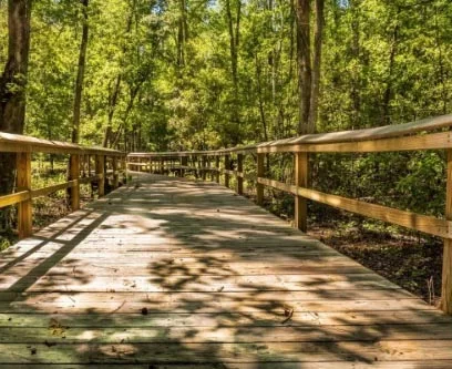
Walterboro’s Great Swamp Sanctuaryis a beautiful place to spend some quality time. The sanctuary contains a network of boardwalks, hiking, biking, and canoe trails that are perfect for viewing a diversity of a black water bottomland habitat. Wild turkey, deer, raccoons, beaver, otter, mink, opossum, squirrels, fox, alligators, and wildcats have been spotted here. Bikes and dogs on leashes are welcome on the pathways of the sanctuary, so load up the family and make your way to this nature-based tourism gem
Downtown Walterboro is another great destination. The city is a popular spot for antiquing. Washington Street has a vast assortment of antiques stores loaded with interesting finds. The Colleton Museum and Farmers Market is located at the end of Washington Street. Visit their Marketplace Café for fresh bakes goods. Beautiful homes can be found everywhere in downtown Walterboro. A walk is the best way to appreciate the lovely structures that were used as summer homes for nearby plantations. Take a nice, leisure stroll to photograph these beauties. Hampton Street is a favorite walking destination. Start here and let your feet guide you through the neighborhood.
Standing sentinel in the isolated woods of Colleton County, Pon Pon Chapel of Ease was once the center of a bustling thoroughfare. Located on what was once a busy stagecoach road, the ruins of this beautiful chapel are all that remains in the area. During the early days of American history, Parker’s Ferry Road connected Charleston and Savannah. President George Washington used this road during his 1791 Spring Tour. Rumor has it he even stopped to worship at the chapel.
Cemetery and back view image by Sara Dean.
Pon Pon Chapel was established during the Colonial Period in 1725 as the first Anglican church in the state. A brick chapel was built in 1754, to replace an earlier wooden structure. This chapel burned in 1801 and became known as Burnt Church. The structure was rebuilt in the early 1820s. The chapel was used lovingly until 1832 when, according to the National Register of Historic Places application, it was either burned or fell into disrepair. Nearby Jacksonboro was replaced by Walterboro as the county seat. As parishioners migrated to Walterboro, there was no need to rebuild. Hurricane Gracie came through the area in 1959 causing further destruction to the structure.
The front of Pon Pon Chapel was repaired in 1975. Image found on the National Register of Historic Places website.
The founder of the Methodist Church, John Wesley preached two sermons from the pulpit of Pon Pon Chapel in 1737. Locals continued to use the churchyard for burials. Two congressmen and several other local leaders are buried here. The Colleton County Historical and Preservation Society acquired the ruins and four acres in 1970. The front facade of the chapel was repaired and stabilized in 1971, then admitted to the National Register of Historic Places in 1972. A grant was awarded to repair the front facade of the chapel in 1975. These ruins stand as a reminder of the early establishment of the Anglican Church in the area.
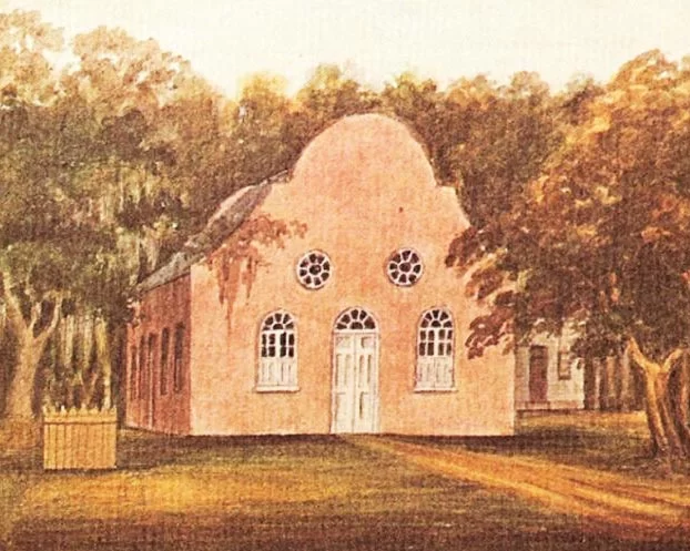
Pon Pon watercolor image shared by Charles Fraser.
Pon Pon’s façade has a central, arched entrance and matching windows on either side. Upper level round windows also grace the front. Large rods stabilize the façade from behind. If you look carefully, you will notice the Flemish Bond brickwork, characteristically constructed with alternating rows of headers and stretchers.
Pon Pon Chapel Ruins can be found off Hwy 64, between Walterboro and Jacksonboro.
Pon Pon Chapel ruins can be found of Hwy 64 (Jacksonboro Road), just outside Jacksonboro at Burnt Church Crossroads. Look for the sign between Jacksonboro and Walterboro. Turn down the dirt road and proceed until you see power lines. The ruins are located just before the power line easement on the right. For more information on Walterboro and Colleton County sights to see, visit https://southcarolinalowcountry.com/walterboro-colleton-county/.
See what our visitors love about the
SOUTH CAROLINA LOWCOUNTRY
Use the #hashtag #sclowcountry to get your image featured!
The Lowcountry & Resort Islands Region of South Carolina includes the four, southern-most counties in the state, Beaufort, Jasper, Hampton, and Colleton, which are bordered on the east by the Atlantic Ocean and on the west by the Savannah River and the state of Georgia.
So happy that “Clouds Gather” has found its forever home. 💖 I hope this painting brings joy and memories of happy times to the new owners. #partagergallerygiftsandhome #acrylicpainting #SCLowcountry #southcarolina
This painting conveys a moment I captured of our son during one of our family beach walks, as we looked for nature’s treasures at low tide. He had broken his arm at the beginning of summer and wasn’t able to participate in his favorite summer activities such as sports and jumping waves in the ocean. As a parent, it was difficult watching him miss out, but I was constantly amazed at his positivity and resilience. Watching him in this moment made me think about how we are always searching and the many places our life’s journey takes us.
Discover at your own leisure at the coastaldiscoverymuseum 🌳 From century-old buildings with storied pasts, to wooden boardwalks that stretch into the Jarvis Creek salt marsh, there`s always something to explore!
Details ✨ • I love the perspective of this first shot. I know the angle isn’t a normal view, if you had this hung in your house, but I just think it’s so badass and cool and it’s my account so I can post it and y’all will just have to deal 😆😜. But really, thanks for all the love you’ve shown me on this piece so far. I’m really proud of it and can’t wait to make more versions of this design. 💙🌾 • Fiber sources tagged 🌊
Spanish moss drapes the live oak trees that are ubiquitous to the Edisto Island area. Did you know that Edisto gets its name from the native Edistow people? The Edistow Native Americans were a sub tribe of the Cusabo indians, a group of Native Americans who lived along the Atlantic coast in South Carolina.
⏰ Best time of the day to visit: Stop by mid-morning. That way you can explore the island, grab lunch, and stay for the amazing sunset if you choose.
🏖️ Things to do while there: Edisto Environmental Learning Center, Boneyard Beach, Scott Creek Inlet, Big Bay Creek, SeaCow Eatery.
☀️ Things to visit in the area: Jungle Road Park, Bay Creek Park, Otter Islands, Spanish Mount Point.
📆 Best time of the year to visit: For warmer weather come anywhere from March-August.
🏨 Where to stay: Fripp Island Golf & Beach Resort (frippislandrsrt), Seabrook Island Club (seabrook_sc), The Sanctuary at Kiawah Island Golf Resort (kiawahresort), Charleston Kiawah Island/Andell Inn (andellinn).
A visitor takes a leisurely stroke under a canopy of live oaks draped with Spanish moss in the Palmetto Bluff (palmettobluff) neighborhood of Bluffton, South Carolina. Palmetto Bluff is a picturesque community that sits in the heart of Lowcountry. Nestled along the May River, it’s abundant with beautiful walking trails, historic sites, and stunning views.
⏰ Best time of the day to visit: There is no wrong time to visit Palmetto Bluff. However, we highly recommend sticking around for one of their spectacular sunsets.
🛶 Things to do while there: Stop by Cole’s for some regionally inspired Southern fare, paddle board, kayak, or canoe along the May River, go saltwater fishing, take a tour at Bluffton Jack`s Old Town Tours.
🌊 Things to visit in the area: Palmetto Bluff Conservancy, Old Town Bluffton, Bluffton Oyster Factory Park, May River Sandbar, Heyward House Museum and Welcome Center (heywardhouse).
📆 Best time of the year to visit: For the best weather, we recommend visiting between March and May or from September to November.
🏨 Where to stay: The Montage Palmetto Bluff Resort (montagepalmettobluff) is the only resort in Palmetto Bluff. However, there are plenty of places to stay in the surrounding areas including: Old Town Bluffton Inn (oldtownblufftoninn), The Inn & Club at Harbour Town (theinnandclubatharbourtown), Sonesta Resort Hilton Head Island (sonestahhi).
Isn`t this live oak tree tunnel beautiful? Live oak, draped in Spanish moss, is emblematic of South Carolina and many of the Southern states. We love these iconic trees, not only for their beauty, but their history as well. The average lifespan of a live oak is 300 years!
The shore gently recedes beneath the stunning Pawleys Island Pier. The unique island town, located about 25 miles south of Myrtle Beach and 70 miles north of Charleston, exudes laid-back, beachy vibes. Locals have definitely adopted an island state of mind and encourage visitors to as well. When you go, make sure to relax on the beach, explore the famous sand dunes, or fish in one of the many adjacent creeks.
⏰ Best time of the day to visit: We guarantee that you’re going to want to spend a whole day here. We recommend getting to the beach at around 10am.
🗓️ Best time of the year: Pawleys Island has the best weather during the spring and early summer months.
🏖️ Things to do while there: Pawleys Island Nature Park, Pawleys Island Chapel, Hopsewee Plantation.
🐠 Things to visit in the area: Brookgreen Gardens (brookgreen_gardens), take a walking ghost tour, Myrtle Beach (mymyrtlebeach), Harborwalk Marina, South Carolina Maritime Museum (southcarolinamaritimemuseum).
🏨 Where to stay: The Oceanfront Litchfield Inn (oceanfrontlitchfieldinn), Litchfield Beach and Golf Resort (litchfieldbeachandgolf), Sea View Inn (seaviewinn), 620 Prince (620prince).
Pregnancy sleep = 😫. Silver lining, a sunrise walk with Sullie and Zoey. _ Anyone else deal with terrible sleep in the third trimester? It`s been brutal. Combo of overall anxiety/mind racing, digestion discomfort and having to pee all the time! 😐 _ #sunrise #follybeach #sclowcountry #scbeaches #goldenretrievers #goldensofinstagram #charleston #29weekspregnant #thirdtrimester #pregnancylife #pregnancyproblems #beach #beachsunrise
Angel Oak, Johns Island, South Carolina. ⠀ ⠀ The Angel Oak Tree is a Southern live oak (Quercus virginiana) located in Angel Oak Park on Johns Island near Charleston, South Carolina. The Angel Oak Tree is estimated to be at least 400 and possibly up to 1400 years old It stands 66.5 ft (20 m) tall, measures 28 ft (8.5 m) in circumference, and produces shade that covers 17,200 square feet (1,600 m2). Its longest branch distance is 187 ft. in length. ⠀ ⠀ #angeloak #angeloaktree #southcarolina #johnsisland #charleston #DiscoverSC #lowcountry #SCLowcountry #lowcountrylife #igerssouthcarolina #blackandwhite #b&w #oaktree #legacyoak #blackandwhite #blackandwhitephotography #totravelistolive #travel_captures #travellove #travelpics #travelpic #travelbug #travelandlife #lifeisajourney #adventuroussoul
The South Carolina Lowcountry Guidebook is filled with many things to see and do in the beautiful Lowcountry of South Carolina. Please fill out the information and we will send you a FREE GUIDE BOOK.


