The Combahee River is Colleton County’s freshwater river of paradise
The Combahee River is a Lowcountry blackwater jewel. It is a 40-mile river that is influenced by the tides. The Combahee joins with the Ashepoo and Edisto Rivers to form the ACE Basin. The river gets its name from the Native American tribe that first inhabited the area. It’s the place where Henry Laurens died during the last fight of the Revolutionary War, and the spot where Harriet Tubman rescued over 750 slaves during the Civil War’s Raid at Combahee Ferry.
The Combahee River is a pristine marshy waterway that dumps into the Atlantic Ocean. The river begins life as a freshwater river at its headwaters in Colleton County. It becomes brackish as it nears the salty waters of the Atlantic. It’s a relatively short and narrow river, but it packs a powerfully beautiful punch. Its water, banks and skies are home to wildlife and flowers in bloom.
Local anglers will tell you its home to all breeds of bream that swim in South Carolina waters. The fish can be found under lily pads fallen trees and near cypress knees. This little Bluegill Bream was caught near Public Landing, then released. It’s a good idea to come prepared with a trolling motor and be on the lookout for shallow depths if heading upstream.
The water turns brackish near Steel Bridge Landing. Fresh and saltwater fish can be found in this area. Redfish and flounder have been known to show up here and further down near St. Helena Sound. Speckled trout frequent the salt waters of the sound as well.
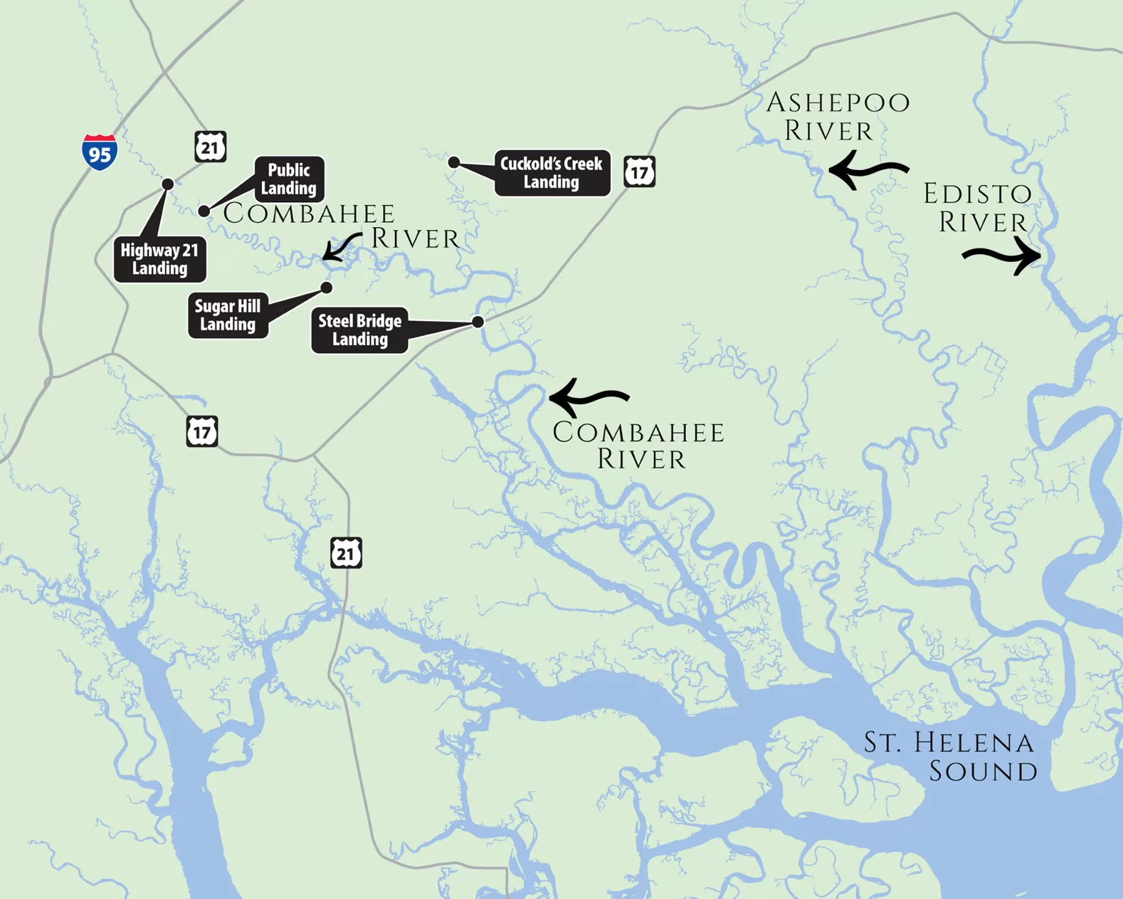
Combahee River Boat Landings Highway 21 Landing – Hwy 17A, Yemassee (1 launch, no dock) Hampton Public Landing – Public Landing Rd, off 17A (2 launch lanes, dock) Colleton Sugar Hill Landing – 40 Sugar Hill Landing Rd, Yemassee (1 launch, no dock) Beaufort Steel Bridge Landing at Harriet Tubman Bridge – Charleston Hwy, Yemassee (2 launch lanes, dock) Beaufort Fields Point Landing – Fields Point Lane, Green Pond (1 launch, no dock) Colleton
The American Revolutionary War Hero that met his end along the Combahee River.
John Laurens was an American soldier and statesman. Born on October 28, 1754, Laurens was the son of Henry Laurens, a plantation owner from Charleston. After studying law in England, Laurens returned to America to join George Washington’s staff during the Revolutionary War in August of 1777. He joined an elite group of aides and secretaries that surrounded the commander in chief. He was very close friends with Alexander Hamilton and the Marquis de Lafayette. Laurens was present in all George Washington’s battles, from Brandywine to Yorktown.
Laurens was quickly known for his thoughts criticizing slavery. As the son of a wealthy slave owner from Charleston, Laurens grew up around slavery and developed very strong feelings against the practice. During the American Revolution, Laurens left Washington’s staff to return to the south and push for legislature to recruit a regiment of black soldiers that would earn their freedom by fighting in the war.
Laurens was a very brave and courageous soldier. He was wounded during the Battle of Germantown (Philadelphia 1777) and again at Coosawhatchie (SC Lowcountry 1779). When General Charles Lee spoke against George Washington’s character in 1778, Laurens wounded him in a duel. Alexander Hamilton acted as his second and ended the duel before a second shot could be fired.
Laurens went on to distinguish himself in Savannah and at the siege of Charleston. Charleston, Laurens was captured by the British during the British victory at Charleston in 1780. He was exchanged and returned to Washington’s staff. Then he was sent to France as a special envoy to appeal to their king for supplies and support. This successful mission led to Cornwallis’s defeat at Yorktown on October 19, 1781. Laurens was designated to aid in the terms of his surrender.
After Yorktown, Laurens travelled back to South Carolina. During a skirmish on the Combahee River, Laurens was killed while leading 50 men and one cannon to reinforce a position in the British rear to cut off their retreat. The British caught wind of Laurens’ movements and ambushed his troops along the route. Laurens was fatally wounded on August 27, 1782. He was only 29 years old.
George Washington was very saddened by the death of one of his most trustworthy aids. In a eulogy to the young soldier, he said, “The Death of Colo Laurens I consider as a very heavy misfortune, not only as it affects the public at large; but particularly to his Family, and all his private Friends and Connections, to whom his amiable and useful Character had rendered him peculiarly dear.” Laurens’ comrade Alexander Hamilton sent a letter to the Marquis de Lafayette: “Poor Laurens; he has fallen a sacrifice to his ardor in a trifling skirmish in South Carolina. You know how truly I loved him and will judge how much I regret him.”
Major General Nathaniel Greene wrote, “Poor Laurens has fallen in a paltry little skirmish. You knew his temper, and I predicted his fate. The love of military glory made him seek it upon occasions unworthy his rank. The state will feel his loss.”
Henry Laurens was buried at Mepkin Abbey, in Moncks Corner, South Carolina.
The Church of the Cross in Old Town Bluffton has been a part of the town’s landscape since 1857 when Bluffton was just a summer resort for the area and inland planters. The handsome cruciform Carpenter’s Gothic Revival building was designed by E. B. White. Mullioned and fan-arched windows are framed by lattice shutters. The rose-colored glass was brought from England. Unfinished cypress timbers cover the structure that rests on a brock foundation.
Image by Carmen Pinckney.
Bluffton was under Federal occupation between 1861 and 1865. While most of the town was burned, the Church of the Cross was spared. The congregation returned after the war, repairs were made, and services resumed in 1870. The church stood unaltered until the roof was replaced in 1892. A deadly hurricane came ashore in 1989 and caused much damage to the building, but repairs were made, and all was well by 1900. Repurposed lumber from repairs was used to make an altar, lectern, and prayer desk. An intimate chapel was created in the narthex that was easy to heat with a pot-bellied stove for the smaller winter congregation.
Images by Carmen Pinckney.
The Church of the Cross in Bluffton was listed on the National Register of Historic Places in 1975. As the congregation grew, members built the first rectory in 1986. Further growth in 1997 moved the narthex wall back to its original position. The balcony above was renovated and is used for the choir and English pipe organ that was installed in 1999.
Images by Mark Kemper, Pinterest, Steven Hyatt, Inez Bunce, Liwei Linand Inez Bunce.
The arched pine front doors lead into a sanctuary bathed in soft light that reflects from pink plaster walls. Two shuttered lancet windows flank the centrally located door. A tripartite lancet window with smaller trefoil-shaped windows on either side sits above the door. The arched-window window design continues along the sides of the church. Exposed beams of hard yellow pine are used in the sanctuary. The gallery’s carved wooden balustrades repeat the pointed arch seen on the exterior.
Images by Greg Branson, Kitty Hoyt and Richard Pedersen.
The Church of the Cross is located on a high bluff, overlooking the May River. It sits in a garden of live oaks and palmetto trees. The board and batten cypress exterior, open timbered interior ceiling is in keeping with the church’s scenic, rural setting. It is an iconic landmark of Old Town Bluffton, and a “must-see” destination while visiting the Lowcountry. In fact, the entire Calhoun Street and Old Town Bluffton area is full of beautiful sights.
The Lowcountry’s newest Reconstruction Era National Site
Historic Mitchelville Freedom Park has joined five other sites throughout the state to be recognized on the Reconstruction Era National Register. The park provides educational and historical interpretation related to the Reconstruction Era, 1861-1900. Mitchelville is especially important in the history of freedom towns that were established during Reconstruction.
Images by Roy Ward, Kathy Jeffers and Austin Phillips.
During the 1861 Battle of Port Royal Hilton Head Island became headquarters for the Union Army. A military order was issued that freed the slaves on the Sea Islands. Former slaves and their children fled the plantations and sought protection with the Union army. They were hired as carpenters, blacksmiths, launderers, coopers, clerks, and cooks. General Ormsby Mitchel set aside a large parcel of land along the coastline for the newly freed population. Quarter-acre lots and building materials were dispersed for the building of homes. Freedmen elected officials and created a system of law. They built churches, stores, and a school system. All children between the ages of six and fifteen were educated. Men were recruited for the on-going Civil War. They built Fort Howell to protect Mitchelville. This was often called the Port Royal Experiment.
Images found on the National Archives.
After the Emancipation Proclamation liberated all slaves on January 1, 1863, Mitchelville became a model for future freedmen towns that were created during Reconstruction. At one time, Mitchelville was home to over 3,000 residents. After the Union army left the island in 1868, Mitchelville’s population began to decrease. When the army left, so did many of the jobs that were given to the freedmen. As time went on, residents took apart their houses and moved inland to farm and participate in local commerce. The town remained until the end of the century. Many of the descendants of Mitchelville citizens still live on the island.
Images by Taiwan Scott, Jennifer Frazier, Matt Penning, Thomas Gibbons, Brian Burch and Daniel McNamara.
According to exploremitchelville.org, “Mitchelville is one of the most significant African-American archaeological sites in the Southeast. It is one of the few that is nearly intact and offers the potential to learn even more about the lives of the early freedmen. It provides another perspective to previous studies of the “Port Royal Experiment.” The presence of Mitchelville also provides evidence of the ability of blacks to govern, educate, and care for themselves absent the bonds of slavery.” A portion of the original Mitchelville site has been protected and placed on the National Register of Historic Places. Visitors can come to the Freedom Park and experience exhibits that show how this town once existed and prospered. Learn about Fort Howell and the 32nd United States Colored Infantry that built it.
Images by Andre J., Charles Moore, Ethan Liu, Gabriel Rico, and Allyson Jones.
Downtown Beaufort has some new colorful benches placed throughout the Cultural arts District. If you’re in town stop, take a load off and learn about the history of this fair city. Twelve benches were built by the Lowcountry Habitat for Humanity and painted by various local artists. Each themed work of art was designed to reflect the artist’s mission, identity, and place in the community.
Artist Omar Patterson designed and painted a bench that was placed on the corner of Bladen and Duke Streets, just outside of the Beaufort Black Chamber of Commerce. The theme of his bench is Lowcountry Dreaming. The Chamber sponsored the bench, which includes the portraits of Frederick Douglass, Harriet Tubman and Beaufort’s own Robert Smalls.
The bench is also beautifully decorated with a Lowcountry sunset, complete with palm trees and marsh grass. This bench captures the spirit of the important African American history in Beaufort.
Artists Sandy Dimke, Frank Anson, Lynne Darling and Tom Van Steenbergh painted the bench that can be found in the courtyard at Bay and Bladen Streets. The theme of the bench captures Beaufort’s earliest history and heritage.
Lowcountry Habitat for Humanity sponsored the bench that can be found at the Henry C. Chambers Waterfront Park. The theme of this bench is “Seeking to put God’s love into action”. Artist Linda Silk Sviland used blue and green to represent the organization. The image shows a blueprint beside the completed home.
Artist Ginger Noah Wareham designed the bench located in front of the Reconstruction Era National Park on Craven Street. The theme of her bench is “United when the impossible suddenly became possible. It was sponsored by the Reconstruction Era National Park. The bench is decorated with a marsh scene that depicts the second founding of America during Reconstruction, from 1861-1898.
Artists Jess O’Brien, Aaron Miller, Shawn Hill, Shelley Barratt, Brian Canada designed and painted the bench at the corner of Carteret and North Streets. Plug-in is the theme and Beaufort Digital Corridor is the sponsor.
Beaufort College – Rich Heritage of Education is the theme for the bench that sits at the entrance to the Center for the Arts on Carteret Street. Artists Mary Ann Ford and John Rodriguez painted the bench and master builder Greg Rawls completed the project. The bench honors the Old Beaufort College Building that was built in 1852. It served as a school for former slaves after the war. It became the Freedmen’s Bureau from 1866-1873. It became a primary school from 1880-1959. It joined the University of South Carolina system in 1959.
The bench in front of Tabernacle Baptist Church was designed and painted by Reverend Johnnie Smith. He used a wood burning technique along with acrylic paint to complete his design. His bench is titled “The Black Church” to memorialize Tabernacle Baptist Church. Founded in 1811, this church became the first Baptist church for Beaufort African Americans in 1863. Reverend Simmons is a Vietnam War veteran and Gullah artist who grew up on St. Helena Island. The bench is decorated with an image of a praise house, baptism in the river and the Tabernacle church. Tabernacle Baptist Church sponsored the bench.
Gullah and heritage-themed subjects are a favorite for artist Lisa Gilyard-Rivers. She painted the bench that will sit on the Bluff. Her bench captures views from the downtown waterfront marina. Sailboats, palm trees and marsh views cover the front of the bench. A Gullah couple can be found on the back of the bench.
This bench by artist Aki Kato is placed outside the Pat Conroy Literary Center on Bladen Street. Kato was a favorite artist of Pat Conroy. He also painted a mural inside the center. His bench is based on the book “The Water is Wide”, which is based on Conroy’s experiences teaching school on Daufuskie Island. The bench was sponsored by the Pat Conroy Literary Center.
The City of Beaufort sponsored the bench that is placed near City Hall. Graphic designer Shawn Hill used images that celebrate city government projects and initiatives throughout the years. The bench shows the city’s commitment to ensure history, charm and businesses survive.
Mather School is the subject of the artwork found on this bench by artist Diane Britton Dunham. The Mather School was founded in 1868 as a boarding school for black girls after emancipation. It continued to educate students for 100 years. It is now part of the Technical College of the Lowcountry. Dunham is an internationally recognized artist known for her illustrations of history and traditional African American southern culture. The bench is sponsored by the Beaufort Arts Council. It is placed on the Technical College of the Lowcountry, in front of the Mather School building.
Scenes from the movie Forrest Gump decorate the bench designed by Linda Silk Sviland. Sponsored by Fripp Island Golf & Beach Resort, the bench sits in the Beaufort Arsenal courtyard. The bench celebrates the iconic movie that was filmed in and around Beaufort and the Lowcountry.
The cultural district’s bench project began in 2019, with the installation of six benches. Six additional benches have recently been placed around town. The benches celebrate the art, history, and culture of Beaufort. Look for these benches in prominent places throughout downtown Beaufort.
All photos were found on the City of Beaufort Facebook page.
Downtown Beaufort’s John Mark Verdier House has recently undergone an extensive facelift. The home has served as a well-preserved museum since 1975, giving visitors a glimpse into the home of a wealthy Beaufort merchant and landowner. Master craftsmen have been working diligently since February to restore the exterior and return the house to its former glory. The work is now complete. A ribbon cutting and reopening ceremony will take place this Saturday, May 8th, at 10 am.
The picture on the left shows the Verdier House before the 2021 exterior restoration. The picture on the right shows the Verdier House as it looks today, after the restoration. Photos by Historic Beaufort Foundation.
The house museum was built in 1804 by a successful merchant and planter. The house was visited by the Marquis de Lafayette on his southern tour in 1825, and later served as the Federal Headquarters by Union troops during the Civil War’s occupation of Beaufort. Luckily, the house remained in the Verdier family until the 1940s. It did, however, led a very colorful life in the early twentieth century. It served as a restaurant, telephone exchange and barber shop. These destructive uses put the house into disrepair. It was slated for demolition in 1944, but a committed group of citizens, that would later be known as the Historic Beaufort Foundation, acquired the house, renovated it, and opened it to the public in 1975.
Civil War occupation.Civil War occupation.The building saw many uses.Before restoration.The Lafayette Building postcard.1975 restoration.Images found on Historic Beaufort Foundation’s Facebook page.
The Verdier House was once called the Lafayette House because of the 1825 visit by the Marquis de Lafayette during his tour of the south.
Photo by HBF.Photo by Carmen Pinckney.Photo by HBF.Photo by Carmen Pinckney.Photo by HBF.Photo by HBF.Existing paint was hand-scrapped, rotten weatherboards were replaced and new paint was applied to the house and shutters.
Walterboro’s Hickory Valley Historic District lies northwest of the National Historic District. The district once had four key properties and fifteen supporting properties. Most of the buildings were constructed between 1821 and 1929 and reflect the architectural characteristics of the period. The homes include a concentration of early homes dating from Walterboro’s heyday as a pineland resort village for lowcountry planters.
Walterboro was founded in 1784 by planters seeking a healthy climate away from the malarial swamps of the Lowcountry. Modest summer cottages soon clustered in a thriving summer resort. The area of Hickory Valley was bound by Webb, Verdier, Valley and Witsell Streets. The area became a town commons, where military drills were performed, political meetings were held and recreation was enjoyed.
334 Wichman Street is home to this one-story Victorian frame residence built in 1910. A veranda extends across the entire front. It is supported by turned posts with sawn brackets. A balustrade connects the posts. The hip roof has a central cross gable with an arched vent and fish-scale shingles. The entrance has a transom and sidelights.
2. The Jones-McDaniel House at 418 Wichman Street was originally built as a one-story structure in 1835 by Jenkins Jones. The McDaniel family purchased the home and altered its appearance drastically in 1935. A semicircular portico was added with four colossal Iconic columns and oversized Scamozzi capitals. One story verandas extend from both sides of the central portico.
3. 125 Magnolia Street is home to this two-story frame house with two tiers of verandas. It was built in 1905 with a superimposed portico. Two Iconic columns on brick bases support a centered pediment. The lower veranda wraps around the sides of the home. It is supported by paired wooden columns on brick bases. The upper veranda has single columns.
4. The Beach-Fogarty House is located at 102 Webb Street. This house was built in 1910. It is a one-half story residence sheathed in weatherboard. The hip roof is accented with a pediment over the portico. The central doorway is surrounded by sidelights and a fanlight.
5. 201 Webb Street is the home of the Edward B. Fishburne House. Built circa 1829, this gable roof frame residence is sheathed in weatherboard. A shed-roofed veranda extends across the façade. It is supported by four square pillars. The five-bay façade has a central doorway complete with elliptical fanlight and sidelights. This house was once one of four key properties of the historic district. It is the only one that is still standing.
6. This one-story frame house can be found at 202 Webb Street. The exterior is covered in weatherboard and has a jerkinhead roof. A central hooded chimney rises from the roof. The entrance is protected by a small, pedimented portico.
Built circa 1920, the one and a half story frame house can be found at 205 Valley Street. A gable roof extends over the front porch with a quadruple window in the gable end. The front parch is supported by six wooden pillars. The central entry is surrounded by a transom and sidelights.
Hickory Valley was designated a Historic District in 1980. It includes several of the earliest and most prominent homes of Walterboro. Major architectural styles from the nineteenth and twentieth centuries are represented. The seven homes presented are all that remains of the district.
The left image is from the Library of Congress from the 1940s. The image on the right shows the condition of the ruins today. Photo by Carmen Pinckney.
Formerly known as Prince William Parrish Church, Old Sheldon Church Ruins sit discreetly off Highway 17. This church is known to be the first attempt in America to create a Greek Temple style of architecture. The church was built sometime between 1745-1753. The church interior was completed, and the first services were held in 1757. The gable roof, pediment, windows, and interior have long been devastated, but the remaining brick shell and columns stand the test of time.
These images are architectural renderings that show how the church has been imagined. The image on the left is from the 1935 book Prince William’s Parish and Plantations, by John Reynard Todd. The left image is a modern digital rendering by Bobby McFadden.
These architectural renderings give us a glimpse of what the original structure looked like. The three-and-a-half-foot thick brick walls are laid in a Flemish bond. All columns and walls have remained intact for 276 years. The church was built along a row of seven Tuscan columns with tall, arched windows. A Palladian window was placed above the alter and flanked by arched windows. The front façade held a massive portico, topped by a triangular pediment complete with bull’s eye window and a cornice with dentil molding. The entranceway was topped with a tall fanlight and two arched windows are positioned on either side.
These images show a digital reconstruction of Old Sheldon Church by a student at Savannah College of Art & Design for the digital technology and historical preservation class with Professor Chad Keller.
This grand chapel of ease stood as a symbol of the wealth that was being accumulated around the area. After completion it was thought of as the finest country church in America. This church is the first example of a temple-form neoclassical building in America. It became a prototype of Greek revival architecture that became characteristic throughout the antebellum south.
Images by Carmen Pinckney.
The church was a political and military center for the area during the Revolutionary War. Governor William Bull was a founding member here and his plantation bordered the church grounds. The Bull family vault in the church yard was used to conceal arms and ammunition. Continental troops drilled on the church grounds. The church was burned by General Augustine Prevost’s British troops in May 1779. The church was rebuilt from the remaining walls in 1825.
1940s images from the Library of Congress.
Traditionally, it was thought that the church was burned again during Sherman’s March to the Sea at the end of the Civil War. While the church was again destroyed, a letter dated February 3, 1866 by Milton Leverett states, “Sheldon Church not burnt. Just torn up in the inside but can be repaired.” It is now thought that the church was gutted by locals who were in search of building materials to rebuild their own war-devastated homes. (This information comes from the Leverett Letters, which was published by the University of South Carolina Press.) After this destruction, the church was abandoned and left to ruin.
Images show the interior view from the alter looking toward the front door, the view from the road and the interior view from the front entrance toward the alter. William Bull’s grave can be seen directly in front of the alter. Images by Carmen Pinckney.
The building was entered onto the National Register of Historic Places on October 22, 1970. The site is owned and maintained by the Parish Church of St. Helena in Beaufort. The ruins are a beautiful feature set amongst ancient live oaks, dripping in Spanish moss, and old graves of members past. Governor William Bull is buried here in a place of honor in front of the interior alter. Today the ruins are surrounded by fencing to protect the historic site. While visiting, please respect the property as hallowed ground. The Sheldon Church Ruins are located on Old Sheldon Church Road between Yemassee and Beaufort, just off Highway 17.
Information found on the National Register of Historic Places, S.C. Dept. of Archives and History, the Leverett Letters, and Historic Resources of the Lowcountry.
Visit Old Town Bluffton’s oldest surviving church.
Photo by Glenn Hanna
The charming and beautifully maintained Campbell Chapel AME Church sits proudly on Bluffton’s Boundary Street. It is the oldest sanctuary in Old Town Bluffton. The modest Greek Revival style church was constructed in 1853 as the Bluffton Methodist Church. The church was acquired by the African Methodist Episcopal congregation for $500 in 1874. The cast iron bell that still hangs in the cupola was installed by the new congregation. The bell is stamped with “B.N. & C.in 0” on the yolk. It was produced by Blymyer Norton & Company, which made bells from 1867-1873. The historic one-story church has a three-bay façade with a double-door entry flanked by two windows. The front portico is supported by four tapered square columns.
Bell images from the National Register of Historic Places. Damage from an early 2oth century storm can be seen in this image found on the Island Packet website.
The church is covered in board and batten siding that was probably applied during the 1874 renovation by the new owners. A 9’6’’ cupola sits on the roof ridge above the front portico. The wing on the right side was a 1966 addition.
Images by Hilton Head Monthly, and Andrew Smith.
Campbell AME Church is significant for its ties to the Bluffton African American community during and after Reconstruction. Nine freedmen purchased the building in 1874. Several of the founders were farmers who prospered in the years following the war. Once purchased, the new congregation altered the building and made improvements that made the building distinctly their own. During Reconstruction, the church served as a church, school, and outreach for the greater community. The church stands as a reminder of the way Bluffton’s freedmen formed a new society in the aftermath of the Civil War. Their changes to the church reflect the booming local economy and the desire to update the building to keep up with new construction in the area.
According to the 2018 National Register of Historic Places application, “The building represents the history of a people anxious to start a new life of freedom and demonstrate a successful start to that new life through the purchase and modification of this church building. Through the safe environment that this church provided, African Americans in late 19th century Bluffton were educated, formed a community structure, and assumed their place in American society.”
Images by Alice DeForest, Andrew Smith and LM GS.
A new, modern worship center was constructed just next door in 2004. This state-of-the-art building has a fellowship hall and sanctuary complete with a balcony. The original church is still functional and in use. For more information on attractions in the South Carolina Lowcountry visit southcarolinalowcountry.com.
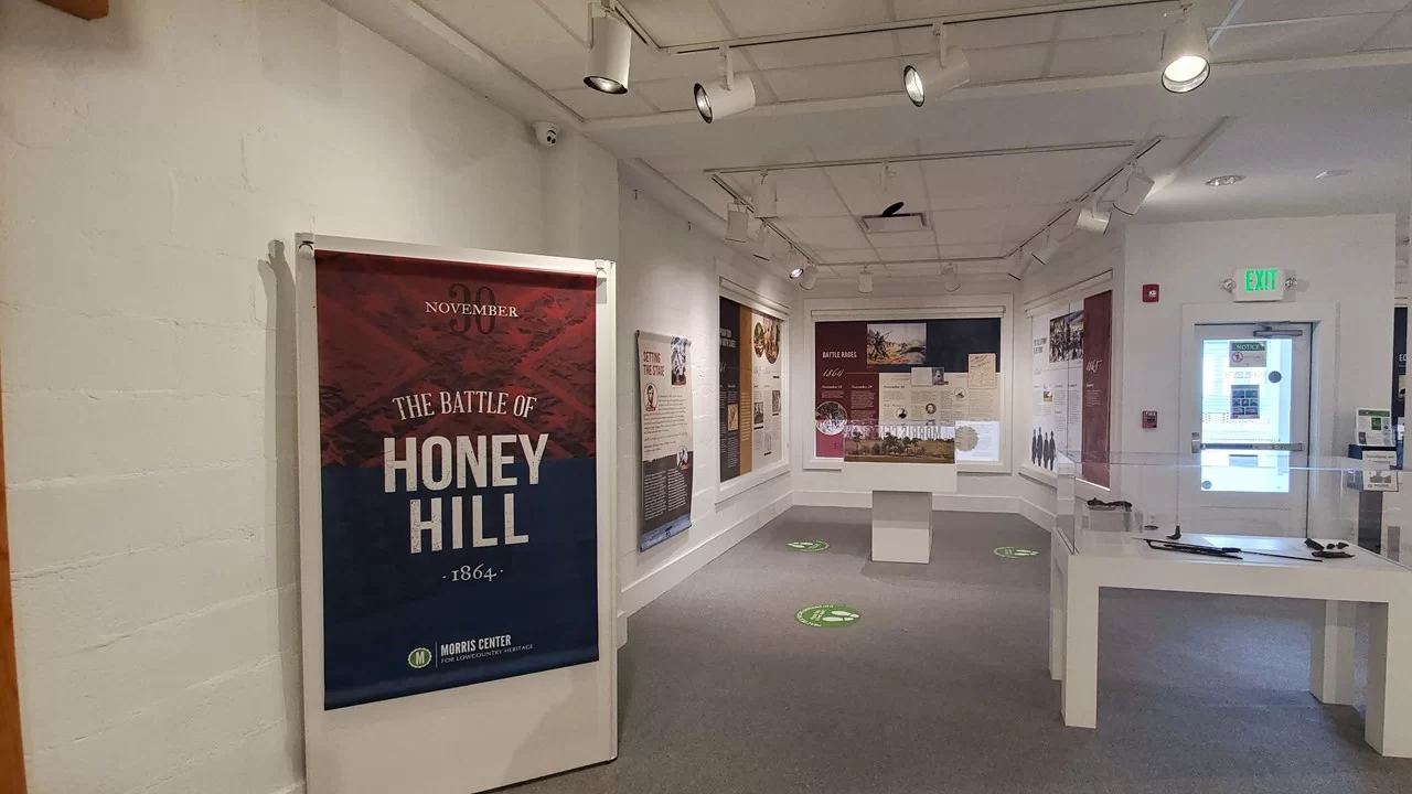
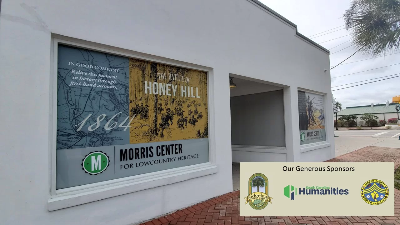
Morris Center Expands Battle of Honey Hill Exhibition
The Morris Center for Lowcountry Heritage is pleased to announce the reopening of its Battle of Honey Hill exhibition. This event is significant because the battle, fought near Ridgeland, S.C., was the first one of the Civil War to involve a large number of African Americans in combat.
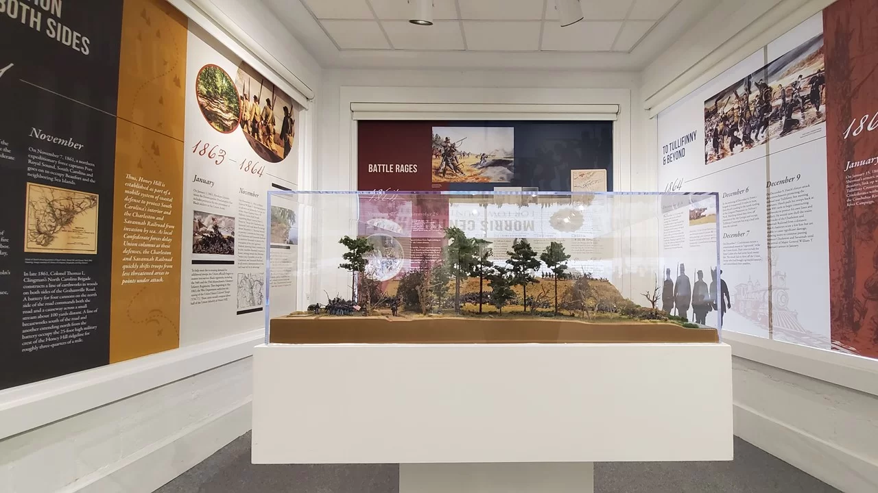
With the existing diorama as the focal point, the exhibit includes new panels that tell a more detailed story of how the battle unfolded, newly unearthed artifacts from the site including tools and ammunition, a tribute to four Medal of Honor recipients, and a section entitled “Voices of Honey Hill” which shares first-hand accounts from some of the soldiers involved.
“Generous support from our sponsors made it possible to expand the exhibit which has been on display here since we opened in 2015,” says Morris Center Executive Director Tamara Herring. “We enlisted the help of Civil War scholars and strived to give it more historical context as well as explain the battle’s significance in terms of the intersection of people who were engaged in it.”
South Carolina Humanities, Town of Ridgeland, and Jasper County provided funds to support the project.
The Morris Center is open to the public Tuesday – Friday from 10:00 a.m. – 4:00 p.m. and Saturday from 10:00 a.m. – 2:00 p.m. For more information, please visit www.morrisheritagecenter.org.
The Morris Center for Lowcountry Heritage is located in the heart of downtown Ridgeland on US 17. This facility is a learning and exhibition center dedicated to preserving and cultivating the history, culture and spirit of Ridgeland and its surrounding counties. Housed in a collection of vintage buildings, with the architecturally distinctive Sinclair Service Station as its focal point, the center features ever-changing exhibitions, interactive and dynamic learning opportunities, cultural offerings, storytelling, and other forms of art.
See what our visitors love about the
SOUTH CAROLINA LOWCOUNTRY
Use the #hashtag #sclowcountry to get your image featured!
The Lowcountry & Resort Islands Region of South Carolina includes the four, southern-most counties in the state, Beaufort, Jasper, Hampton, and Colleton, which are bordered on the east by the Atlantic Ocean and on the west by the Savannah River and the state of Georgia.
So happy that “Clouds Gather” has found its forever home. 💖 I hope this painting brings joy and memories of happy times to the new owners. #partagergallerygiftsandhome #acrylicpainting #SCLowcountry #southcarolina
This painting conveys a moment I captured of our son during one of our family beach walks, as we looked for nature’s treasures at low tide. He had broken his arm at the beginning of summer and wasn’t able to participate in his favorite summer activities such as sports and jumping waves in the ocean. As a parent, it was difficult watching him miss out, but I was constantly amazed at his positivity and resilience. Watching him in this moment made me think about how we are always searching and the many places our life’s journey takes us.
Discover at your own leisure at the coastaldiscoverymuseum 🌳 From century-old buildings with storied pasts, to wooden boardwalks that stretch into the Jarvis Creek salt marsh, there`s always something to explore!
Details ✨ • I love the perspective of this first shot. I know the angle isn’t a normal view, if you had this hung in your house, but I just think it’s so badass and cool and it’s my account so I can post it and y’all will just have to deal 😆😜. But really, thanks for all the love you’ve shown me on this piece so far. I’m really proud of it and can’t wait to make more versions of this design. 💙🌾 • Fiber sources tagged 🌊
Spanish moss drapes the live oak trees that are ubiquitous to the Edisto Island area. Did you know that Edisto gets its name from the native Edistow people? The Edistow Native Americans were a sub tribe of the Cusabo indians, a group of Native Americans who lived along the Atlantic coast in South Carolina.
⏰ Best time of the day to visit: Stop by mid-morning. That way you can explore the island, grab lunch, and stay for the amazing sunset if you choose.
🏖️ Things to do while there: Edisto Environmental Learning Center, Boneyard Beach, Scott Creek Inlet, Big Bay Creek, SeaCow Eatery.
☀️ Things to visit in the area: Jungle Road Park, Bay Creek Park, Otter Islands, Spanish Mount Point.
📆 Best time of the year to visit: For warmer weather come anywhere from March-August.
🏨 Where to stay: Fripp Island Golf & Beach Resort (frippislandrsrt), Seabrook Island Club (seabrook_sc), The Sanctuary at Kiawah Island Golf Resort (kiawahresort), Charleston Kiawah Island/Andell Inn (andellinn).
A visitor takes a leisurely stroke under a canopy of live oaks draped with Spanish moss in the Palmetto Bluff (palmettobluff) neighborhood of Bluffton, South Carolina. Palmetto Bluff is a picturesque community that sits in the heart of Lowcountry. Nestled along the May River, it’s abundant with beautiful walking trails, historic sites, and stunning views.
⏰ Best time of the day to visit: There is no wrong time to visit Palmetto Bluff. However, we highly recommend sticking around for one of their spectacular sunsets.
🛶 Things to do while there: Stop by Cole’s for some regionally inspired Southern fare, paddle board, kayak, or canoe along the May River, go saltwater fishing, take a tour at Bluffton Jack`s Old Town Tours.
🌊 Things to visit in the area: Palmetto Bluff Conservancy, Old Town Bluffton, Bluffton Oyster Factory Park, May River Sandbar, Heyward House Museum and Welcome Center (heywardhouse).
📆 Best time of the year to visit: For the best weather, we recommend visiting between March and May or from September to November.
🏨 Where to stay: The Montage Palmetto Bluff Resort (montagepalmettobluff) is the only resort in Palmetto Bluff. However, there are plenty of places to stay in the surrounding areas including: Old Town Bluffton Inn (oldtownblufftoninn), The Inn & Club at Harbour Town (theinnandclubatharbourtown), Sonesta Resort Hilton Head Island (sonestahhi).
Isn`t this live oak tree tunnel beautiful? Live oak, draped in Spanish moss, is emblematic of South Carolina and many of the Southern states. We love these iconic trees, not only for their beauty, but their history as well. The average lifespan of a live oak is 300 years!
The shore gently recedes beneath the stunning Pawleys Island Pier. The unique island town, located about 25 miles south of Myrtle Beach and 70 miles north of Charleston, exudes laid-back, beachy vibes. Locals have definitely adopted an island state of mind and encourage visitors to as well. When you go, make sure to relax on the beach, explore the famous sand dunes, or fish in one of the many adjacent creeks.
⏰ Best time of the day to visit: We guarantee that you’re going to want to spend a whole day here. We recommend getting to the beach at around 10am.
🗓️ Best time of the year: Pawleys Island has the best weather during the spring and early summer months.
🏖️ Things to do while there: Pawleys Island Nature Park, Pawleys Island Chapel, Hopsewee Plantation.
🐠 Things to visit in the area: Brookgreen Gardens (brookgreen_gardens), take a walking ghost tour, Myrtle Beach (mymyrtlebeach), Harborwalk Marina, South Carolina Maritime Museum (southcarolinamaritimemuseum).
🏨 Where to stay: The Oceanfront Litchfield Inn (oceanfrontlitchfieldinn), Litchfield Beach and Golf Resort (litchfieldbeachandgolf), Sea View Inn (seaviewinn), 620 Prince (620prince).
Pregnancy sleep = 😫. Silver lining, a sunrise walk with Sullie and Zoey. _ Anyone else deal with terrible sleep in the third trimester? It`s been brutal. Combo of overall anxiety/mind racing, digestion discomfort and having to pee all the time! 😐 _ #sunrise #follybeach #sclowcountry #scbeaches #goldenretrievers #goldensofinstagram #charleston #29weekspregnant #thirdtrimester #pregnancylife #pregnancyproblems #beach #beachsunrise
Angel Oak, Johns Island, South Carolina. ⠀ ⠀ The Angel Oak Tree is a Southern live oak (Quercus virginiana) located in Angel Oak Park on Johns Island near Charleston, South Carolina. The Angel Oak Tree is estimated to be at least 400 and possibly up to 1400 years old It stands 66.5 ft (20 m) tall, measures 28 ft (8.5 m) in circumference, and produces shade that covers 17,200 square feet (1,600 m2). Its longest branch distance is 187 ft. in length. ⠀ ⠀ #angeloak #angeloaktree #southcarolina #johnsisland #charleston #DiscoverSC #lowcountry #SCLowcountry #lowcountrylife #igerssouthcarolina #blackandwhite #b&w #oaktree #legacyoak #blackandwhite #blackandwhitephotography #totravelistolive #travel_captures #travellove #travelpics #travelpic #travelbug #travelandlife #lifeisajourney #adventuroussoul
The South Carolina Lowcountry Guidebook is filled with many things to see and do in the beautiful Lowcountry of South Carolina. Please fill out the information and we will send you a FREE GUIDE BOOK.


