Driving Detour Through Yemassee

Step back in time to visit the historic wonders of this small town.

Old Sheldon Church Road
Old Sheldon Church Road is just past the turn to Beaufort on SC Hwy. 17.
Photo by Carmen Pinckney.

Many travelers enjoy driving Highway 17, between Charleston and Savannah. The naturally beautiful landscape of Yemassee is located between the two cities. A simple turn off Hwy 17 onto Old Sheldon Church Road is like stepping back in time. Travel up the road for about two miles and see the church ruins on the right. Parking is located across the street. This church was burned during the Revolutionary War, rebuilt and then destroyed again during the Civil War. There is a debate as to whether the church was burned or disassembled during the Civil War.

Old Sheldon Church Ruins
Old Sheldon Church Ruins stand proud.
Photo by Carmen Pinckney.

The following is from an article in the April 1969 Sandlapper Magazine by Charles E. Thomas, “The Picturesque Ruins of Old Sheldon Church”. “The official South Carolina report on the ‘Destruction of Churches and Church Property,’ after the War Between the States, described Sheldon’s second burning: All that was combustible was consumed…, its massive walls survive the last as they did the former conflagration, Bishop Thomas wrote, Exactly as it happened a hundred years before in 1779, when General Prevost, marching from Savannah into South Carolina burned the Church, so now in February 1865, General Sherman marching from Georgia into South Carolina, burned it a second time.”

However, another account found more recently states that the church was not burnt at all.

Old Sheldon Church Ruins
Old Sheldon Church interior photo by Carmen Pinckney.

In a letter dated February 3, 1866, Beaufort’s Milton Leverett wrote, “Sheldon Church not burnt. Just torn up in the inside but can be repaired.” The inside of the church was apparently gutted to reuse materials in rebuilding the area homes that were burnt by Sherman’s army. Today the Old Sheldon Church Ruins are protected by fencing to ensure their protection. Visitors can meander all around the structure while maintaining a safe distance from the ancient walls.

After visiting the ruins, continue up Old Sheldon Church Road and head into Yemassee.  Cross the railroad tracks and keep left. Cross Hwy 17A and turn left onto Hwy 68. Head out of town and to the other side of I-95. Take a left at Davidson Tower Road and another left at the end onto Pocotaligo Road. Travel about two miles to find two more hidden gems.                       

Sheldon Chapel Episcopal
Sheldon Chapel Episcopal photo by Carmen Pinckney.

Sheldon Chapel Episcopal, formerly of Prince William Parish sits proudly on the left at 25481 Pocotaligo Road. Dated to 1745, the church was dismantled and used to build bridges by Gen. Sherman during the Civil War then rebuilt in 1898.

Stoney Creek Chapel
Forrest Gump’s Stoney Creek Chapel
photo by Carmen Pinckney.

If you turn left directly after the church, you will come upon another historic structure. Fans of the movie Forest Gump will recognize this church. Forrest went to church here to pray that he and Lieutenant Dan would find shrimp. Built in 1833 this chapel was used for seasonal worship. It is the only pre-Civil War structure in this area. During the war the chapel was used as a hospital and campsite by Union troops.

Retrace your path and come back to Old Sheldon Road. Turn right onto Cotton Hall. This will lead you back to highway 17 and past the gates and oak avenues of two beautiful plantations. While the homes aren’t visible to passersby, the entrances are photo worthy.

Yemassee Plantation Driveway
Driveway on Cotton Hall Road. Photo by Carmen Pinckney.

A drive into Yemassee is a fun way to add a historical detour into your drive down Highway 17. We hope you enjoy the scenery. For more interesting pit stops in the South Carolina Lowcountry visit https://southcarolinalowcountry.com/category/blog/.

Yemassee Plantation Driveway
Another driveway on Cotton Hall Road.
Photo by Carmen Pinckney.
Read More

Old Town Bluffton


Heyward House
Heyward House photo by Carmen Pinckney.

A drive to Old Town Bluffton is always a good idea. The historic architecture and river views are spectacular. There is also a hidden gem worked into the landscape. Today’s outing started at the Heyward House, located at 70 Boundary St. This property has been in Bluffton since 1841. The house serves as Bluffton’s official Welcome Center and museum. The house is decorated in period furnishings and is complete with artifacts that tell the story of Bluffton, and the people that once lived there. There are also outbuildings located behind the house that represent a cook house and slave quarters.

For more information on the Heyward House  https://www.heywardhouse.org/ .


Cross Episcopal Church
Church of the Cross photo by Carmen Pinckney.

Another historic treasure is located just a few streets away at 110 Calhoun Street. The Church of the Cross has stood on the bluff of the May River since 1854.  This Gothic structure celebrated its 150th anniversary in 2004.

Additional history on the church can be found here  http://www.thechurchofthecross.net/history

Campbell AME Church
Campbell AME Church photo by Carmen Pinckney.

The oldest church in Old Town Bluffton dates to 1853. The Bluffton Methodist Church building was purchased by nine former slaves in 1874. Campbell Chapel AME Church was formed by these visionary founding fathers. While the structure has been altered and renovated over the years, the original structure still stands strong and proud.


Bluffton Oyster Company
Bluffton Oyster Company photo by Carmen Pinckney.

The Bluffton Oyster Company has been a part of Old Town Bluffton since 1899. It sits on is reclaimed land at the end of Warf Street. This land built up by more than a hundred years’ worth of discarded shells. Situated directly adjacent is the Oyster Factory Park. The park has a nature trail which is unique for the Old Town area. There is also a firepit area, a playground and plenty of picnic spots. Restrooms are conveniently located here also. 

For more information http://blufftonoyster.com/

Garvin-Garvey House
Garvin-Garvey House photo by Carmen Pinckney.

The Garvin-Garvey Freeman’s Cottage is located inside the park. This historically significant house has recently undergone extensive renovations. It is believed that former slave Cyrus Garvin built the house on the property of his former owner.

Views of the May River are spectacular from the front porch. Tours are available through the Heyward House.

Prichard Pocket Garden
Pritchard Pocket Garden photo by Carmen Pinckney.

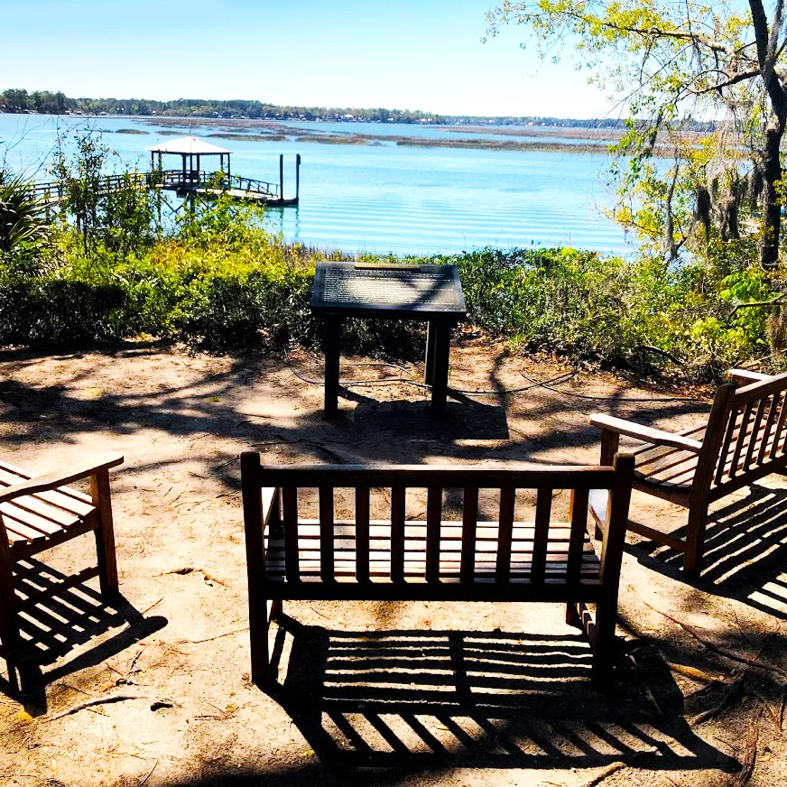
Another fun stop in Old Town is the Pritchard Pocket Garden. Located where the street meets the river, this little hidden gem was worth the trouble of finding it. Parking is along the road. Entrance is through a small gate and down a short path. Benches are set up on the bluff that overlooks the May River. It is a calm and relaxing spot to breathe in the SC Lowcountry at its finest, and a great way to end the day exploring Old Town Bluffton.

May River View
Pritchard Pocket Garden view photo by Carmen Pinckney.

There are many other fun and interesting attractions in Old Town Bluffton. For more information visit https://southcarolinalowcountry.com/bluffton-day-trips/.

Read More

Donnelley Wildlife Management Area

Donnelley is a favorite spot for tourists and locals alike. It is located on Hwy 17 in Green Pond (between Yemassee and Jacksonboro) in the heart of the ACE Basin. Open from dawn to dusk, this is a great place to glimpse Lowcountry nature at its finest. The property features a historic rice field system, which is now managed to attract waterfowl and migratory birds. The drive is pleasantly lined with beautiful old live oaks.

Donnelley Wildlife Management Area drive
Photo by Carmen Pinckney.

Donnelley has walking trails and a driving tour. Navigating is best done using a map. Pick one up at the office or download one HERE. This map gives great details of all aspects of the property. The map also shows the locations of restrooms.

Donnelley Wildlife Management Area  wood stork
Wood Stork. Photo Credit: Ira Runyan

The first trail takes you to a dike across an old rice field reserve. This is a great spot to see endangered Wood Storks. Driving further in, you cross an ancient rice field dike that was constructed in the 18th century. The Boynton Nature Trail is next. This 2.2-mile walking trail circles another part of the old rice field complex. All types of waterfowl can be viewed here and throughout the property.

Donnelley Wildlife Management Area trunk system
Photo by Carmen Pinckney.

Driving further onto the property brings you to the historic rice trunk, which features floodgates that can be raised or lowered to control water levels in the rice fields.

Look for alligators. They can be found sunning on the banks or floating lazily by in the water.

Further onto the property brings you to fields and meadows, where several types of birds and mammals can be found.

Donnelley Wildlife Management Area alligator
An alligators basks in the sun. Photo by Carmen Pinckney.

The driving tour covers about 11 miles and should take from an hour to half a day, depending on how many stops you make. The marked stops on the map serve simply as suggestions; feel free to stop anywhere along the way (although please park on the shoulder) and walk off the road at any point to get a closer look at wildlife or native plants. Take extra precautions when viewing alligators, especially during the spring mating season.

Photo by Carmen Pinckney.


Donnelley Wildlife Management Area
585 Donnelley Dr.
Green Pond, SC
TRAILMAP
Other Colleton County Attractions
Colleton County Day Trips

For more information visit the DNR website.


Read More

Tour Pinckney Island

Pinckney Island Wildlife Management Area

Pinckney Island National Wildlife Refuge marsh view
The view at high tide. Photo by Carmen Pinckney.


This 4,053-acre national refuge consists of salt marsh and tidal creeks, forests, grasslands, and freshwater ponds. In combination, these habitats support a diversity of wildlife species.

All trips begin and end at the parking area half a mile from the refuge entrance. Touring this beautiful island is fun on foot or by bicycle. There are over 14 miles of trails to enjoy. Coastal Discovery Museum offers walking tours of Pinckney Island, enlisting the expertise of an experienced bird watcher.

Pinckney Island National Wildlife Refuge with wildlife biologist Charles Pinckney
Wildlife biologist and Pinckney descendant Charles Pinckney. Photo by Carmen Pinckney.

For this this trip I took bicycles and my wildlife biologist husband, who happens to be a descendant of the Pinckney family. With his extensive knowledge of the area flora and fauna, we never know what we’re going to find.

Pinckney Island is named for Charles Cotesworth Pinckney, a South Carolina founding father and previous owner of the island. The island, a once prosperous sea island cotton plantation, was donated to the United States in 1975 to be used as a wildlife refuge and a nature and forest preserve.

Pinckney Island National Wildlife Refuge trails
The main gravel roads are very bicycle friendly.
Photo by Carmen Pinckney.

Pinckney Island is a great place to view, study, and photograph wildlife. The views are breath-taking. Bring lunch and picnic on the shores. Maps are available in the parking lot. I highly recommend taking one on your hike so you can judge distances and where paths connect and intersect.

The main gravel roads are very bicycle friendly. The grassy trails are a little more challenging, but well worth it.

There are many ponds and marshy areas along the way to stop and look for wildlife. Look for egrets and alligators to make an appearance. There is also a butterfly garden for your enjoyment.

Pinckney Island National Wildlife Refuge marsh view
Nature is at its finest on Pinckney Island.
Photo by Carmen Pinckney.

Keep in mind, while hiking or biking there are no bathroom facilities. Also, visitors must also bring their own drinking water. Furry friends are not allowed on the island. Antique and artifact hunting is not allowed.

Pinckney Island is located on Hwy 278, between Bluffton & Hilton Head Island

Guided tours are available through the Coastal Discovery Museum
(843)689-6767, ext. 223.

TRAILMAP
Bluffton Day Trips
Hilton Head Day Trips

Read More

Edisto Island’s Botany Bay

Botany Bay entrance
The entrance to Botany Bay is through a beautiful canopy of live oaks.
Photo by Carmen Pinckney.

The wildlife management area of Botany Bay Plantation is one of the most unique destinations on Edisto Island. The 4.000+ acre property boasts historical buildings, maritime forest, beach and fresh water ponds. Historically it was two plantations (Bleak Hall and Sea Cloud), that grew sea island cotton and timber. The property is covered in pine, palm and live oak trees, dripping with Spanish moss. Don’t be surprised to see deer, alligators, shore birds, crabs, raccoons and many other maritime forest creatures.

There are two sites listed on the register of historic places. A set of three surviving 1840s outbuildings and the prehistoric Fig Island Shell Ring can be seen on the property.

Explore the plantation house ruins, walk the forest trails, or stroll the beach on this South Carolina controlled wildlife management area

Botany Bay’s beach is often referred to as “Boneyard Beach”. Sun bleached standing and fallen trees line the beach.

Botany Bay does not allow pets, so you’ll have to leave the furry friends behind. Shell removal is also prohibited.

Botany Bay trees
Ancient live oaks can be seen throughout the property.
Photo by Carmen Pinckney.

Botany Bay is open from sunrise to sunset. It is closed Tuesdays and for scheduled hunts.

The plantation is located on Botany Bay Road on Edisto Island. This road is home to the most photographed oak tree canopy in the area. Once in the park, visitors must check in at the information kiosk. A map is available with very informative descriptions of every aspect of the plantation.

Botany Bay horse friendly
Bring your horses for a fun day at Botany Bay.
Photo by Carmen Pinckney.

When you continue the driving tour you will see a house, pasture and barn on the right. Horse trailers can park and check in here for trail riding. This was the winter home of the last owner of the property. It is currently the DNR property manager’s home.

Just ahead, at the bend in the road, take a right and park to access the beach and Indian Point. A path leads to Hammock Island, a barrier island that is covered in shells. Remember, no shells can be removed. Beach combers get creative with their shell finds and hang them in the palms and oaks along the beach.

Time your walk on the beach with low tide. The beach disappears when the tide rolls in.

Botany Bay shells
Finding shells is enjoyable, but they can not be removed from the beach.
Photo by Carmen Pinckney.

After leaving the beach visitors enter what was once the grounds of Bleak Hall Planation. Remaining are two out buildings and a well. The larger white building had multiple purposes, including an ice house, carriage house and general storage. The smaller building was a gardener’s shed. This building is made from tabby, which is made from oyster shells.

Another tabby building sits just past the Bleak Hall home site. It was used as a barn and equipment shed. After proceeding past the barn, visitors can look for wildlife in the agricultural fields. More wildlife viewing can be found past live oak trees that border Ocella Creek.

Botany Bay ice house
Botany Bay’s ice house.
Photo by Carmen Pinckney.

A cottage chimney that dates to 1893 still stands near Ocella Creek. Picnic Pond is located on the left after the cottage ruins. This pond was dug to build dikes on the property. This is a great spot to view wood ducks and the occasional alligator. Next you cross the dike. On the left isJason’s Lake, and the Ocella Creek is on the right. The road continues left, but you can follow the signs to Sea Cloud Landing on Ocella Creek. Kayaks and canoes can be launched here. Boats must be brought in on car tops. No trailers allowed. Ospreys and eagles hunt here regularly. Pelicans also spend time here.

Botany Bay brown pelican
A brown pelican stands watch near the water’s edge.
Photo by Carmen Pinckney.

Sea Cloud Plantation sits on the other side of the dike. Agricultural fields are planted and maintained for wildlife. Just past the fields sits the ruins of the Sea Cloud Plantation house. The brick foundation is all that remains of what was once an elegant home with a ballroom that graced the entire third floor. As the driving tour continues to the other side of Jason’s Lake, the ruins of a bee hive well (that was built around 1825) can be seen.

Botany Bay drive
Visitors get to enjoy the canopy one last time as they exit Botany Bay.
Photo by Carmen Pinckney.

The road continues through a pine-hardwood forest. When the road ends, a left turn takes you back toward the beach, a right takes you out of the plantation.

Botany Bay Wildlife Management Area is a great place to spend a day. Bring a picnic, beach chairs and kayaks. Explore the wonders of the South Carolina Lowcountry plantation style!

TOURMAP
More attractions on Edisto Island
Edisto Island Day Trips

Read More

Sergeant Jasper Park

Sgt Jasper lake view

Sgt. Jasper Park is conveniently located off I-95, at Exit 8. After exiting the interstate, point toward Hilton Head and turn left at the first traffic light. Follow the road around until you bump into the park entrance. Trails are located on both sides of the road. Some trails are wheelchair accessible. This is a great place to get off the interstate and stretch your legs. Dogs are welcome here, on a leash. A trail map is available in the park office.

Sgt Jasper boardwalkThe trails alternate between gravel, boardwalk and natural footing. The views around the lake are pretty, and the trails are relaxing. 

There are other opportunities at the part as well. There are canoes, kayaks and a disk golf course. Information can be found in the park office. There’s a playground for the kids and plenty of picnic spots. There is also a covered picnic shelter. Grills can be found at the park as well. The disk golf course is located on the left side of the road. The park also has fishing opportunities.


1458 Red Dam Rd.
Hardeeville, SC 29927
Call 843-784-5130
PARKMAP
PARKBROCHURE

More Day Trips in the South Carolina Lowcountry
More Hardeeville Attractions


Read More

Watermelon Festival Time

Watermelons are in season and you know what that means… the Watermelon Festival is in town! Yee-haw!

If you are familiar with this event, you know that it is the one time a year you get to devote an entire week to fun, food, and festivities! If you are not familiar with the Watermelon Festival, you should sit down because the excitement and good times can be overwhelming!

2017 marks the 75th Annual Hampton County Watermelon Festival. During this week there are all kinds of events happening, including but not limited to: petting zoos, arts and craft contests, “Taste of Hampton County,” Blue Grass concerts, a street dance, 5K, and my favorite the watermelon eating contest! Free watermelon slices will be given out during certain times of the week and there is even a historic tour of the Old Jail. The week’s dates are  – .

If all this amusement is not enough to get you to come, this year’s theme is “Honoring Our Teachers.” You can take a moment to remember and think back to some of the most influential people in your life while enjoying a cool, refreshing, delicious slice of melon. You can’t lose! Check out the Hampton County website for more information http://www.melonfest.org/ and get down to Hampton today.

Just spit the seeds on the ground… we don’t mind!

Memorial Day Edisto Beach Retreat – Memorial Day 2017

Your Memorial Day Edisto Beach Retreat is here and is the official start of summer! Where else would I rather be on a long weekend like this, than at the beach? South Carolina has a plethora of beautiful beach locations with many different offerings for whatever your heart desires. One of my favorites is Edisto Beach. I have spent a bit of time every summer of my life so far at this location, and I will continue to return until the tides of my days cease.

Why do I love Edisto? Is it simply the nostalgia of the same beach house that I long for in the cold winter months? No, it is not just these wistful memories that bring me back to Edisto in the warm times. It is mostly the simplicity and ease of the island. There are not many distractions – provigil generic. There are no loud noises – except for seagulls and doves outside your window in the morning. There is no real schedule to adhere to either. Well, that is unless it rains, and then you must simply settle for relaxing with a book while listening to the rain on the roof.

So this Memorial Day, I decided to go back to a time and place that was simpler, that is less like reality, to recall good stories, easy times and who I am, and hopefully to make some new memories along the way.

Read More

Memorial Marker for the Whippy Swamp Muster Group

This past Wednesday, a gentleman came by our Visitors’ Center at the Frampton Plantation House and the first thing he said when he walked in was “This place sure doesn’t look like it did the last time I was here!” Well, we have added some new gift items and displays, but that wasn’t what he was talking about. Turns out he hadn’t been here in about 60 years. At that time, he said he was working in Mr. Campbell’s field culling watermelons. It is really neat that our director, Jim Wescott, was able to get this wonderful plantation house saved for our Commission to serve as our offices and Visitors’ Center!!!

Anyway, William W. Corbin, Jr, this former farm hand, will be speaking today at the dedication of the Historic Marker for the Whippy Swamp Muster Group. Mr. Corbin is quite the historian and will be speaking about the guard and its part of the Civil War today at 3 pm at the Harmony Presbyterian Church located just outside of Hampton on Hwy 601 North in Crocketville. I’m getting ready to leave right now to be a part of history. Come join me!!!

See what our visitors love about the
SOUTH CAROLINA LOWCOUNTRY

Use the #hashtag #sclowcountry to get your image featured!

The Lowcountry & Resort Islands Region of South Carolina includes the four, southern-most counties in the state, Beaufort, Jasper, Hampton, and Colleton, which are bordered on the east by the Atlantic Ocean and on the west by the Savannah River and the state of Georgia.

The South Carolina Lowcountry Guidebook is filled with many things to see and do in the beautiful Lowcountry of South Carolina. Please fill out the information and we will send you a FREE GUIDE BOOK.

    Stay Up To Date

    Sign up for our newsletter!